The following map puts all of this together:
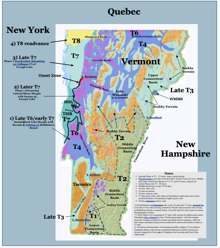
Of course, owing to scale limitations this map is unavoidably schematic. As can be seen this map shows multiple margins and events representing the recession of the Lobate Phase beginning in T3 time, and continuing to T8 time.
Addendum revisions to this history include:
- Destabilization of the Champlain lobe, as marked by Streaks and calving in the Middlebury Bench re-entrant Basins associated with the Coveville to Fort Ann lowering in late T6 and early T7 time, is approximated by the transition from the T6 to T7 time boundary. However, owing to scale limitations, the footprints and strandlines for the Coveville and Fort Ann water bodies in the “Disaggregated,” more or less open water corridors, and calving margins of ice masses in Middlebury Bench re-entrant basins, with downgradient recession toward the Trough in T7 time are not shown.
- The first phase of streaming as marked by Scarps, triggered by the recession of the ice margin to the Trough, resulting in loss of the Middlebury Bench buttressing support for the Champlain lobe, is marked by the dotted black line and darker green shading.
- The Onset Zone for this first phase of streaming is marked by the red line in the Shelburne vicinity.
- The second phase of streaming and possibly a collapse(?) of the Champlain lobe, attributable to opening of the Onset Zone (likened to a dam break) and sudden and substantial lowering of Fort Ann to Champlain Sea levels in later T7 time when accelerated streaming began, is marked by the lighter green shading. As noted, this second phase is suggested by the absence of Scarps in the northern Champlain Basin. Curvilinear erosion marks on LiDAR imagery in the Onset Zone near Shelburne document the opening of the basin for the incursion of the Champlain Sea as part of the trigger for the second phase of streaming. The recession of the ice margin for this second phase of streaming is unmarked, which is attributed to the absence of a coherent ice margin. The progressive northward recession of the frontal portion of this second phase of streaming by calving is indicated by the evidence provided by the previous State surficial geology map showing bouldery lacustrine and marine silts and clays on the Basin floor northward to the Quebec border.
- The T8 readvance was restricted to the Missisquoi Basin.