As previously stated, this entire study was originally inspired by research in Quebec which identified moraines associated with deglacial history. Thus, from the outset, this study took on a regional interest. Reports and discussions with Franzi and Brouard provided further perspective on deglaciation from the perspective of a more regional setting.
A report by Margold et al (2014, 2015) 1Margold, M, Stokes, C.R., and Clark, C.D., and Kleman, 2014, Ice streams in the Laurentide Ice Sheet: a new mapping inventory; https://doi.org/10.1080/17445647.2014.912036; Margold, M, Stokes, C.R., and Clark, C.D., 2015, Ice streams in the Laurentide Ice Sheet: Identification, Characteristics, and comparison to modern ice sheets. Earth Scienmce Reviews, V. 143, pp. 117-146. and as well research by others including Winsborrow, Boulton, and Kleman helped me better understand multiple factors associated with Glacial Dynamics and ice streaming. The following is a summary of these factors, with my comments pertaining to Vermont added (in italics and reduced font):
- Physiography and topography: Margold et al identify “Onset Zones,” where ice streams are buttressed by necking of the terrain.
The Onset Zone is depicted on above maps, but the map below provides helpful physiographic detail:
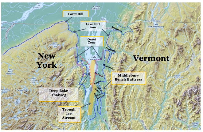
This map shows the Fort Ann strandline in Vermont, taken from Chapman and for the equivalent Lake Akawasasne in New York from Franzi et al 2 In a presentation by David A. Franzi, Sean Grasing, Emily McLean, David Barclay, and Jason Briner entitled “Bridging the gap: glacial geomorphic mapping in the Adirondack Upland, New York, dated 3/5/26” by dark blue lines. Chapman’s depiction infers a flattened, restricted ice margin position in northern Vermont in Fort Ann time prior to further recession leading to the opening of the Champlain Basin for the incursion of the Champlain Sea. The evidence presented elsewhere in this present report documents the close association of the ice margin with Fort Ann waters, extending further north to and beyond the Quebec Border. As is now established, the Fort Ann Lake Vermont equivalent strandline has been identified in Quebec as Lake Candona. The dotted blue line on the above map shows the approximate (schematic) northward continuation of the Fort Ann strandline to the Quebec border. In addition, the same Franzi et al reference delineates an ice margin identified as the “Covey Hill- Ellenburg – Plattsburgh Ice Margin,” which is closely associated with the Akawasasne (or Fort Ann) strandline. It is here presumed that this ice margin is approximately correlative with the late T6 and early T7 ice margin identified in Vermont. In other words, by this thinking the blue line in the Champlain Basin is taken as approximately marking the destabilized ice lobe at this time as marked by Streaks. The Trough ice stream as marked by Scarps is also shown.
It is significant that the T7 ice margin in New York and Vermont shows a necking, associated with the physiography. In Vermont this necking is associated with the Middlebury Bench which has already been identified as providing buttressing support for the Champlain lobe prior to recession of the Champlain lobe to the Trough 3 The suggestion that the Middlebury Bench is a significant physiographic element of the Champlain Basin, can be readily seen by travel in the area, with the northern frontal face of the Bench appearing as an obvious rise in the terrain. Thus, the idea that this physiography likely impacted the flow of the Champlain lobe is quite plausible and sensible. The necking of the terrain on the New York and Vermont sides of the Basin is interpreted as having served as an Onset Zone for ice streaming to the south, as depicted on the above map.
In addition, as noted previously, the Onset Zone likely as well has a vertical component associated with the thalweg of the “Deep Lake,” suggesting that streaming may as well have been associated with substantial erosion related to the Onset Zone and extending northward on the over-deepened basin floor. This has to do with the Glacial Dynamics of ice streaming. As noted previously in connection with Bierman’s studies in Vermont and elsewhere, such over- deepening may have been associated with long term, multiple glaciations.
It is interesting that studies of the Finger Lakes region suggest that ice streaming may have been associated with the over-deepening in manner possibly similar to the Champlain Basin and the Onset Zone, as for example in reports by Mullens and Hinchey (1989) 4 Mullins, H.T. & Hinchey, E.J. (1989). “Erosion and infill of New York Finger Lakes: Implications for Laurentide ice sheet deglaciation.” Geology, 17, 622–625. and Sookhan et al. (2021) 5Sookhan, S., Eyles, N., Bukhari, S., & Paulen, R. C. (2021). “LiDAR-based quantitative assessment of drumlin to mega-scale glacial lineation continuums and flow of the paleo Seneca-Cayuga paleo-ice stream.” Quaternary Science Reviews, 263, 107003. https://doi.org/10.1016/j.quascirev.2021.107003.
2. Ice thickness: Ice deforms and flows faster where the driving stress (essentially ice thickness × surface slope) becomes large enough. Thicker ice or a steeper surface slope increases basal shear stress, helping initiate faster flow, as part of streaming Dynamics. Ice thickness of ice streams changes substantially with steeper gradients associated with ice streaming downgradient from Onset Zones.
Ice thickness is important in multiple ways. The Scarps mapped in the Addendum suggest ice streaming in the Trough area downgradient from the Onset Zone, as depicted on the above map. In addition, ice thickness differences account for widespread ice stagnation in the Middlebury Bench between the re-entrant basins ( perhaps caused by hydrofracturing, as previously suggested) with calving of narrow ice masses (ice streams?) in the re-entrant basins. However, whereas the ice in the re-entrant basins was confined to these basins like ice streams, with associated calving, whether or not these were true “ice streams” is uncertain.
3. Basal thermal regime (warm vs. cold bed): A key control is whether the bed reaches the pressure-melting point. When ice at the base warms enough to allow liquid water, basal friction drops dramatically. Many onset zones coincide with transitions from Cold-based, frozen-bed ice upstream to Warm-based, sliding ice downstream.
The evidence indicates that the Champlain lobe was mostly Cold at early times, as marked by Ice Marginal Channels, but became substantially warmed as indicated by the absence of Ice Marginal Channels and other evidence as discussed above associated with T7 and T8 times.
4. Subglacial and ice margin hydrology: Water at the bed reduces friction and can organize flow. Onset zones commonly occur where and when:
- basal water is substantial
- drainage systems switch from distributed (slow) to channelized or pressurized flow
- effective pressure drops, enhancing sliding
Whereas subglacial water may be substantial, as in basal tunnels, even thin water films or deformable water-saturated sediment may be important.
The importance of hydrology for Vermont deglacial history is evident in many ways. This reflects the reverse gradient physiographic setting for most of the ice sheet in Vermont, which led to a step-down type recession from T4 to T7 time along the eastern margin of the Champlain lobe. In northern Vermont, between the Missisquoi and Lamoille Basins, the terrain resulted in a complex sequence of local ponding as marked by Bedrock Grooves which represent active ice in tandem with stagnant ice as a Hybrid type margin. Further south, the terrain resulted in meltwater entrapment, likely for a substantial portion of the Champlain lobe surface water watershed, resulting in the Shattuck Mountain Potholes.
Until recently I believed that the very substantial complex of linear bedrock controlled ridges and swales, along the foothills between the Lamoille and Winooski Basins represented multiple surface meltwater channels along the lateral Champlain lobe margin in T5 and T7 times. However, as discussed above, field work as part of this Addendum study generally failed to document the presence of sand and gravel type deposits on the floors of these swales as was expected. Instead, field examination showed the presence of a very distinctive till, similar to that observed by Wright and myself in the LaPLatte Basin and which I found associated with Scarps. I now suspect that this uneven terrain was occupied by basal meltwater tunnels in which very substantial rounded gravel stones, subsequently became incorporated into till as part of the lateral shear margin associated with ice streaming. Further, again as discussed above, the very substantial stagnant ice deposit near Williston, and the associated spillway at Oak Hill formed by basal ice tunnel drainage both point to the presence of significant meltwater both along and beneath the Champlain lobe margin.
5. Sediment type and deformable till: Where the bed is composed of weak, water-saturated till (or other fine grained sediment) , the glacier may begin to “ride” on a deforming substrate. This can trigger a sudden increase in velocity. Conversely, hard-bed rock tends to resist onset unless other factors (heat, water) overcome it.
5. Sediment type and deformable till: Where the bed is composed of weak, water-saturated till (or other fine grained sediment) , the glacier may begin to “ride” on a deforming substrate. This can trigger a sudden increase in velocity. Conversely, hard-bed rock tends to resist onset unless other factors (heat, water) overcome it.
6. Ice-sheet geometry and mass balance gradients: Changes in accumulation rate inland vs. downstream influence the longitudinal stress gradient. Where accumulation increases ice flux faster than the ice can deform internally, the system can “switch” into faster flow.
It is believed that the Onset Zone served as a transition in gradient for the first phase of streaming.
It is posited that the clearing of the Onset Zone associated with further recessional ice sheet lowering, in conjunction with the opening of the Basin for the incursion of the Champlain Sea by the northward extension of the narrow “Disaggregated corridor along the eastern lobe margin led to an accelerated second phase of streaming and associated calving of the Champlain lobe, perhaps representing its “collapse(?).” This interpretation is suggested and supported by the absence of Scarps in the northern Champlain Basin, north of the Onset Zone, by the erosional grooves in the Onset Zone, and by bouldery lacustrine and marine sediments on the Basin floor which are shown on the Stewart and McClintock State map as extending northward to the Quebec border.
As discussed in the literature, such a collapse(?) in a reverse gradient setting, as for the Champlain lobe, typically is not marked by ice margin features. This reflects the ice sheet’s” falling apart” and the attendant lack of any coherent recessional ice margins.
A “collapse” is a matter of Glacier Dynamics. For example, Bukhari et al 6 Bukhari, Eyles, Mulligan, Burt , Eyles, Paulen, Ross, and Putkinen, 2024, Laurentide Ice Sheet configuration in southern Ontario, Canada during the last glaciation (MIS 4 to 2) from stratigraphic drilling and LIDAR-based surficial mapping; Canadian Journal of Earth Sciences Volume 61, Issue 10, 5 July 2024, Pages 1076-1103 present an intriguing study in Ontario which bears on the findings here for Vermont. They suggest that the traditional “layer cake” model for assessing deglacial history represents a classical paradigm which should instead be replaced by a model which takes into account the diachronous nature of glaciation associated with different sedimentary facies at any given time:
“… early litho-stratigraphic work on Quaternary deposits in southern Ontario adopted the same approach and assumed a simple regional layer cake stratigraphy controlled by regional climates and synchronous fluctuations in ice flowing through widely separated lake basins (Dreimanis and Karrow 1972; Karrow etal. 2000). Tills were assigned to formally recognized cold climate stades, and glaciolacustrine or glaciofluvial sediments, to warm interstadials. This simple approach does not lend it-self to detailed investigations of complex glacial deposits and environments characterized by markedly diachronous ice advances and retreats and marked spatial variations in depositional settings and ensuing depositional facies.”
Instead, the authors suggest a depositional systems approach which identifies major events in glacial history. Applied to Vermont, for example, based on the information found in this present study, this thinking might suggest multiple discrete events which represent the interplay of deglacial history, Styles, and Glacial Dynamics:
- A Nunatak Phase representing a time (T1-T3 times), when the ice sheet was basically a Cold type, with warming restricted to the margins of the ice sheet, as marked by Ice Marginal Channels. The multiple Disconnections of ice masses in the Connecticut Basin represent an associated part of this Glacial Dynamic, as part of this Phase.
- A Lobate Phase (late T3 to late T6 times), beginning with a late T3 and T4 readvance, with progressive step-down recession of Hybrid margins in relatively steeply sloping terrain, with increasing volumes of meltwater in a reverse gradient setting with ponded water bodies along the ice margin with Drainage Lines representing “connective tissue” between lobes and associated water bodies. The progressive enlargement of these ponded water bodies, led to an increasingly fragile Glacial Dynamic equilibrium between the ice sheet and its associated environmental boundary conditions or Styles, with the potential for destabilization of the Champlain lobe sector of the Laurentide ice sheet.
- An Instability Streaming and Calving Phase in late T6 and T7 times, with three discrete subphases of increasing instability:
a. The sudden and substantial lowering of Lake Vermont from the Coveville to the Fort Ann levels which triggered destabilization of the entire Champlain lobe in Vermont as marked by Streaks, with calving of ice masses within the Middlebury Bench re-entrant basins, as marked by Ribbed Lacustrine, Headless Delta, and Thickened Bouldery Lacustrine deposits.
b. The streaming and calving of the Champlain lobe triggered by the loss of buttressing support associated with recession of the Champlain lobe from the Middlebury Bench to the Trough, as marked by Scarps.
c. Accelerated streaming or collapse (?) of the Champlain lobe triggered by the opening of the Onset Zone and by the sudden and substantial lowering of Lake Vermont from the Fort Ann level to the Champlain Sea via a narrow Disaggregated open water corridor along the lobe eastern margin, is “marked” by the absence of Scarps, erosional grooves in the Onset Zone and bouldery lacustrine and marine sediment on the floor of the Basin which extend northward to the Quebec border.
As stated by Bukhari et al, (p. 1090), two episodes of fast flow can be identified in southern Ontario, the second of which ended and was associated with the “collapse” of the St Lawrence ice stream. As stated on page 1093:
“The St. Lawrence Ice Stream had collapsed (emphasis added) and fully retreated by c.13,500–12,800 ybp (Parent and Occhietti 1999;Occhietti et al. 2001; Dalton et al. 2020). This marks the end of ice streaming in southern Ontario, the final drainage of glacial Lake Iroquois and deglaciation of the study area (Dyke2004; Donnelly et al. 2005).”
These authors go on to state that the usage of the term “collapse” is appropriate.
A report by Robel and Tziperman (2016) 7 Robel. A.A. and Tziperman, E.. 2016, The role of ice stream dynamics in deglaciation, https://doi.org/10.1002/2016JF003937Digital Object Identifier (DOI)suggests that Onset Zones are associated with increased surface ice sheet gradients with lowering of the ice sheet by streaming below the Onset Zone, resulting in an imbalance between the accumulation and ablation zone leading to accelerated ice flow.
Accordingly, the Onset Zone in Vermont may be likened to an ice dam such that further recession led to a dam break. Of key importance is whether this break took place gradually or suddenly. The multiple erosional grooves on the Onset Zone suggest progressive dam break. This collapse(?) of the Champlain lobe is “marked,” so to speak, primarily by the absence of Scarps, which poses a philosophical conundrum of proving the negative by the absence of specific evidence. Further study of this issue is needed, perhaps by examination of soil boring and water well drilling logs in the late Fort Ann and Champlain Sea bottom sediments, which may provide clues regarding such a collapse.
I do not use the term “Collapse” glibly, and I did not begin this Addendum study with this in mind. Instead, as discussed further below, this realization grew and evolved from multiple pieces of information from which the concept of “collapse” emerged. Defining what exactly is a “collapse, and proving that the Champlain lobe actually “collapsed” is challenging and not easy. The concept of “collapse” is, of course, a matter of substantial present-day concern. In fact, it is posited here that the findings of this present study may help us better understand present-day ice sheets in the context of global warming. The evidence from this Addendum study makes clear that the recession of the Champlain lobe involved a Glacial Dynamic, with substantial evidence about this Dynamic. For me, this was an unexpected, surprising finding, and prompted me to rethink the evidence about the recession of the ice sheet and the subject of Glacial Dynamics generally, an exploration leading to yet more “Epiphanies.”
The term “collapse” has special meaning, again referring to a Glacial Dynamic by which that portion of an ice sheet no longer functions as a cohesive entity. The literature suggests that in a reverse gradient setting, such as existed in the Champlain Basin, this collapse is not, and can not be, marked by ordinary geomorphic or sedimentologic evidence. However, again as previously noted, in Vermont and as well in neighboring regions of New York and Quebec, any such evidence might be found within the late Fort Ann and early Champlain Sea bottom sediments, specifically in the northern portion of the Basin. Whereas Lake Champlain bottom sediment cores have documented the marine and postglacial sediment conditions, in general these studies have not closely examined the deeper, older, and northern Lake Vermont materials in regard to collapse evidence. It is also possible that well drilling records might shed light on the nature of the Fort Ann sediment in this area, but to date these have not been studied with this in mind. It would seem that the best location to look for evidence might be along the late T7 to T8 ice margins, especially in the piedmont of southern Quebec, but so far as is known this aspect has not as yet been studied. Thus, the “collapse(?) of the Champlain lobe is recognized as likely but is not yet proven.
In general, the term and concept of “collapse” generally refers to instability, ice streaming, calving, and rapid ice sheet level lowering and recession of the ice margin. Most significantly and critically, ice lobe, ice sheet, or glacier collapse in its essence can be a non-reversible, self-perpetuating condition beyond a “tipping point,” leading to a substantial, usually rapid recession of the ice margin. In a worst case scenario a collapse can lead to the complete demise of a glacier or ice sheet lobe. A collapse can be caused by multiple, different triggers related to the Glacial Dynamic destabilization of an ice lobe or glacier, and is a Glacial Dynamic for a glacier, ice sheet, or a lobe to return back to a “normal” condition, or reequilibration. Such collapse may result in the demise of a lobe or ice sheet or may be intermittent and progressive.
Finally, the age dates available for this recession, as noted above, likewise suggest a very speedy recession, possibly consistent with a collapse. This recession of the Champlain lobe as just described is broadly bracketed by dates for the correlation of the T3/T4 margin with the White Mountain Morainic System, which is dated as about 13,800 – 14,000 years BP and by the incursion of the Champlain Sea in Vermont which is dated at about 13,000 years BP. Thus, this recession occurred in less (probably much less) than about 800 – 1000 years. This rate of recession is comparable to modern day ice sheet margin calving recession rates, and possibly in the range of modern day collapse recession rates.
The recession rate in Vermont is, of course, indeterminable in exact terms from the above dates, and uncertain ice margin positions, but taking the distance from the Onset Zone to the Quebec border as about 65 km (40 miles), the recession rate likely would have been much faster than 65 km (40 miles)/800 years, or >81 m per year (>264 feet per year).
Published ice margin recession rates vary:
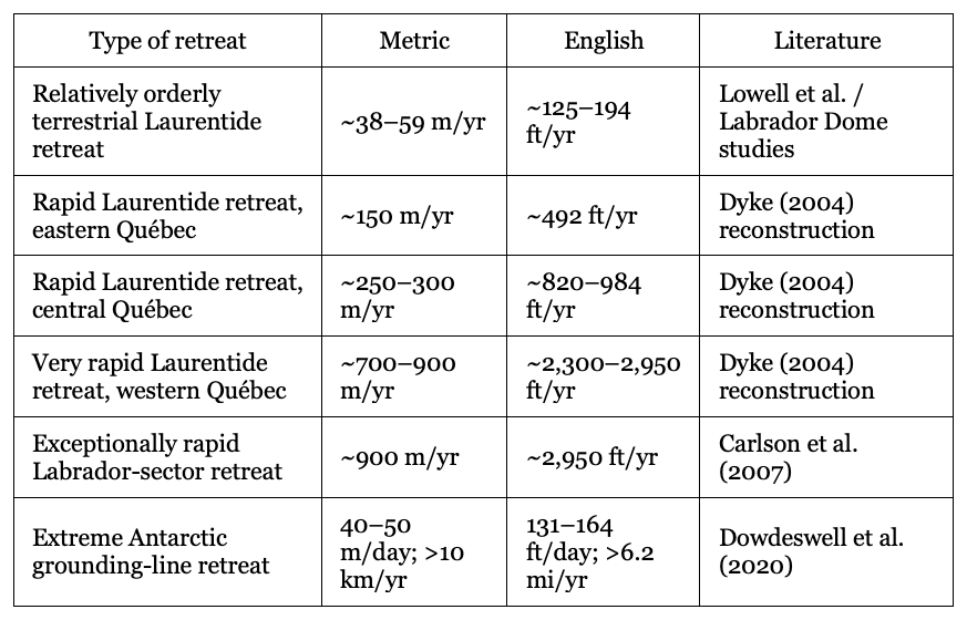
Thus, the recession rate for the Champlain lobe plausibly may be comparable to collapse rates.