Following the late T3 readvance, the T4 ice margin stood at the divide between this Basin and the Memphremagog Basin, marking the recession of the ice margin in T4 time. The T4 margin was a hybrid type margin, marked by both Ice Marginal Channels and stagnant ice deposits, with T4 Ice Marginal Channels correlated with the Dixville moraine in Quebec, based on their close proximity, alignment, and similar elevations.
The following map represents T4 time:
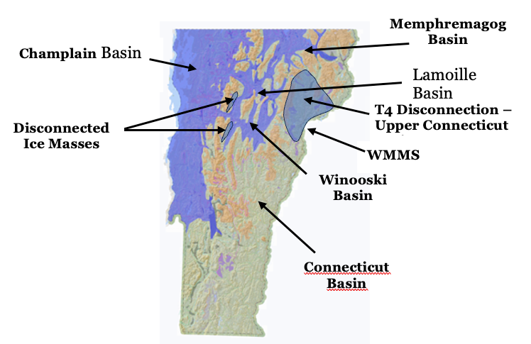
As just stated, in the Memphremagog Basin T4 time Ice Marginal Channels are closely related to T4 time stagnant ice deposits, as a hybrid margin. Lowering of the ice sheet in T4 time resulted in stagnant ice margins at divides between the Memphremagog Basin and neighboring Lamoille and Connecticut Basins, with Disconnection and en masse stagnation of the former ice lobe in the Upper Connecticut Basin. The T4 hybrid margin is well marked in the Memphremagog Basin and Champlain Basins by stagnant ice deposits, Ice Marginal Channels, and Bedrock Grooves, this last in the northern Champlain Basin along the western flank of the Green Mountains and the foothills. The Bedrock Grooves represent substantial meltwater along Cold, active ice margins. Late T3 time marks the beginning of the step-down sequence of ice margin recession in southern Vermont, with T4 time marking the beginning of this progression in the remainder of Vermont, with such step-down evidence becoming more substantial with time, along with progressively larger, coalescing standing water bodies, indicating increasing volumes of meltwater as an important part of the Glacial Dynamic for the Champlain lobe. Larger proglacial water bodies posed more potential for significant Glacial Dynamic effects on the ice sheet.
T4 time was closely associated with proglacial Lake Winooski, as discussed in the pre-Addendum report, corresponding with the ice mass in the in the upland interior Winooski and Lamoille Basins. This Lake is not shown on the above map, but its footprint can be inferred by the configuration of T4 time ice cover on the above map. Lake Winooski was a substantial proglacial water body with its lowering through three progressively lower levels, representing an important part of deglacial history, as described by Wright et al. As also discussed in the pre-Addendum report, ice recession of this interior ice mass in the upper Winooski and Lamoille Basins was associated with a Glacial Dynamic involving penetration of a narrow more or less open water “Disaggregated” corridor for early Lake Winooski, along the perimeter of the Late T3 and T4 ice margin.
Also, as discussed previously, on the eastern margin of Lake Winooski this penetration is marked by recession of a hybrid type margin between longer lasting ice in stagnant ice deposits with graded relationships downward to Lake Winooski kame deltas. And on the western side of the Lake Winooski basin, similarly rapid penetration of Lake Winooski waters severed and isolated, possibly still active ice masses in deep valleys on the eastern flank of the Green Mountains. Again, these corridors and Disconnection represent a significant Glacial Dynamic. In addition, the final drainage of this interior proglacial water body in late T6 and T7 time added to the Glacial Dynamic of the Champlain lobe as part of its destabilization.
In southwestern Vermont the T4 margin stood at the mouth of the Vermont Valley, marked by Stewart and MacClintock’s major moraine near Rutland. LiDAR imagery along this margin clearly shows recessional markings indicating both westward downgradient recession of the lateral margin and northward recession of the frontal tip. Portions of this margin include both stagnant ice deposits and kame delta deposits showing the close relationship between the ice margin and standing water related to the step-down sequence of local water bodies, giving direct evidence of the close Glacial Dynamic interplay between standing water in proglacial water bodies and the ice margin.
The T4 margin wrapped around the nose of the Taconics, with the frontal tip of the ice margin in the main floor of the Champlain Basin standing near Benson Landing, again with the margin marked by kame delta deposits.