In the course of this Addendum inspection of LiDAR imagery, the presence of features in the Champlain Basin appearing physiologically like and referred to as “Scarps” were identified. These occur at a narrow range of elevations along the margin of the Trough as depicted schematically by the feint white line on the same previously shown map below:
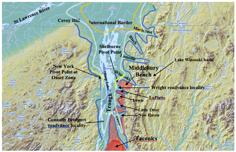
Scarps have the following characteristics:
- They are distinctive, straight to curved, linear geomorphic forms, appearing on LiDAR imagery as three-dimensional, edge-like features on the landscape, looking just like physical scarps.
- In the field, Scarps are topographically evident as steeper frontal slopes of benches formed by Ribbed Lacustrine deposits.
- Taken together in map view, Scarps define a late T7 margin. Similar Ribbed Lacustrine deposits above the late T7 level and before this time, but still within the T7 margin do not appear to be associated with Scarps.
- Scarp bases are sharp, curvilinear horizontal traces, with no apparent lateral topographic gradient. These bases occur close to but always and consistently slightly above the elevation of the Champlain Sea marine limit, at diverse, scattered locations, when Scarp base elevations are adjusted for isostatic rebound.
- The terrain everywhere in the vicinities of such Scarps and their associated Ribbed Lacustrine deposits is mantled by thin and patchy silt-clay surficial soil deposits indicative of standing water, as is consistent with Ribbed Lacustrine Deposits, with no evidence of coarse textured granular soils at Scarps and their bases as might be expected if these features were formed by running or standing water erosion.
- They are distinctive, straight to curved, linear geomorphic forms, appearing on LiDAR imagery as three-dimensional, edge-like features on the landscape, looking just like physical scarps.
- In the field, Scarps are topographically evident as steeper frontal slopes of benches formed by Ribbed Lacustrine deposits.
- Taken together in map view, Scarps define a late T7 margin. Similar Ribbed Lacustrine deposits above the late T7 level and before this time, but still within the T7 margin do not appear to be associated with Scarps.
- Scarp bases are sharp, curvilinear horizontal traces, with no apparent lateral topographic gradient. These bases occur close to but always and consistently slightly above the elevation of the Champlain Sea marine limit, at diverse, scattered locations, when Scarp base elevations are adjusted for isostatic rebound.
- Scarp bases are sharp, curvilinear horizontal traces, with no apparent lateral topographic gradient. These bases occur close to but always and consistently slightly above the elevation of the Champlain Sea marine limit, at diverse, scattered locations, when Scarp base elevations are adjusted for isostatic rebound.
- Scarps and their associated Ribbed Lacustrine deposits when viewed regionally in map view depict a pattern suggestive of ice lobes along the flanks of the Trough portion of the main Champlain Basin and as well in certain but not all tributary Basins, closely associated with physiography. Together they suggest ice lobes: a) Along the floor of the central, main Champlain Basin “Trough” as this Basin floor was described previously, essentially along the slope between the Middlebury Bench and the Trough, with Scarps extending along the lateral slope of the Trough from the vicinity of Mount Independence, (at the southwestern extent of the Bench), east of the village of Orwell, northward to the Colchester vicinity, just north of the mouth of the Winooski Basin. Thus, Scarps essentially mark multiple locations along the entire length of the Middlebury Bench, again on the western slope of the Bench as the terrain descends to the main Trough Basin floor.b) In the southern re-entrant tributary Basins in the Middlebury Bench, in and along the mouth margins of these Basins, specifically including Braisted Branch, West and East Branches of Dead Creak, lower Otter Creek, and Lemon Fair basins. In other words, Scarps mark tributary lobes penetrating individual re-entrant basins in the southern portion of the Basin, but not in the re-entrant basins to the north. The explanation for this difference is given below and has to do with the orientation of these southern basins versus the more northerly basins, relative to differences in ice sheet accessibility.
- In a sense, Scarps and Ribbed Lacustrine deposits together represent a “Signature” ice margin marker on VCGI imagery, thanks to the distinctive appearance of Scarps and Ribbed Lacustrine deposits on LiDAR, which can be used independently of Bath Tub model terrain elevations, similar to the T3/T4 Ice Margin Channel signature, as described previously, in this case marking and helping to identify a late T7 margin.
Multiple hypotheses have been considered for the origin of Scarps:
- Fluvial or Strandline erosion: The geomorphic forms of the scarps resemble and are suggestive of fluvial erosion or shoreline erosion, with truncation of the Ribbed Lacustrine deposits. However, a) the fact that the bottoms of scarps are horizontal and trace topographic contours, with no gradient argues against a fluvial origin and b) the lack of coarse granular textured soil material argues against strandline or fluvial erosion. In fact, the Champlain Sea strandline , as mapped by me in my 1972 report, is marked by numerous and extensive beaches and deltaic deposits associated with typical granular materials. This strandline is consistently close to but slightly lower than the Scarps, which lack any such coarse textured material. Again, the landscape on, above, and immediately below the scarps is everywhere fine grained silt-clay material as mapped both on the S & M map and as well by the SCS soil map, and as examined by me directly in the field. Thus this hypothesis is discarded.
- Buttressing support: Alternatively, the scarps may have formed by a Glacial Dynamic related to the recession of active ice buttressing support of the stagnant ice masse fringe associated with and marked by Ribbed Lacustrine and other stagnant ice deposits. In essence, this hypothesis suggests that the Scarps were formed along the support margin provided by active ice on basin floors abutting against stagnant ice located on topographic bench areas along basin margins areas where ice thickness favored stagnation, as marked by the Ribbed Lacustrine stagnant ice deposits, leaving Scarps behind as the ice retreated. However, the buttressing support theory would not seem to account for or fit with the sharp, smooth faces of Scarps. Nor does this concept explain the sharp line-like bottom of Scarp faces.
- Lateral Shear Moraines (LSMs): The concept of buttressing support is very similar to another concept which was brought to mind, thanks to a report by Batchelor and Dowdeswell (2016). 1 Batchelor, C. L. & Dowdeswell, J. A. (2016). Lateral shear-moraines and lateral marginal-moraines of palaeo-ice streams. Quaternary Science Reviews, 151, 166–185. These authors describe different types of features associated with calving ice margins and associated ice streams, as illustrated on their Figure 12 below:
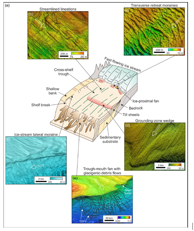
“Ice-stream lateral moraines,” also referred to by the authors as “Lateral Shear Moraines” (LSMs), reportedly form at and mark the subglacial lateral shear zone margins of present day ice streams, between ice streams and slower-flowing regions of a calving ice sheet or tongue. It is believed that the Scarps found here in Vermont represent or are similar and related to LSMs. Whereas these authors describe such features as actual ridges, such ridges generally have not been identified in this 2026 examination, either on LiDAR or in the field. Batchelor and Dowdeswell (2016) focus on the development of ridges but underscore the erosional nature of shear margins. According to one of the authors (Christine Batchelor, 2026, personal communication), it is plausible that lateral shear margins at certain times and places can be dominated by erosion, particularly if the ice is in an extensional ice regime or if meltwater efficiently evacuates sediment. Batchelor referred me to a report by Hindmarsh and Stokes (2007 and 2008), [mfm] Hindmarsh, R. C. A. & Stokes, C. R. (2008) — Formation mechanisms for ice‑stream lateral shear margin moraines, Earth Surface Processes and Landforms 33(4): 610–626. [/mfn] who state that “lateral shear margins of paleo‑ice stream beds are occasionally marked by large curvilinear moraines …. .” (underscore added)
It appears that Lateral Shear margins represent a highly dynamic, active erosive and associated depositional glacial environment close to but above the grounding line. For actual ridge moraines to form requires the availability of substantial material to build moraines, and sufficient time for their construction, and under certain, favorable ice flow regime conditions. It is believed that in Vermont the recession of the calving ice margin was rapid owing to the reverse gradient setting, such that insufficient time and perhaps material, was available for moraine formation. Furthermore, Scarps tend to be associated with the eastern flank of the Trough, which is fundamentally relatively steeply sloping terrain, sloping downward to the west with thin soils over bedrock, again indicating that the availability of unconsolidated type material for building moraine ridges was limited. The presence of bedrock outcroppings along Scarp faces is consistent with an erosion mechanism for their formation.
The following sketch provides a transverse cross sectional profile to illustrate the nature of Scarps, for the main central Champlain lobe, in the “Trough” in late T7 time:
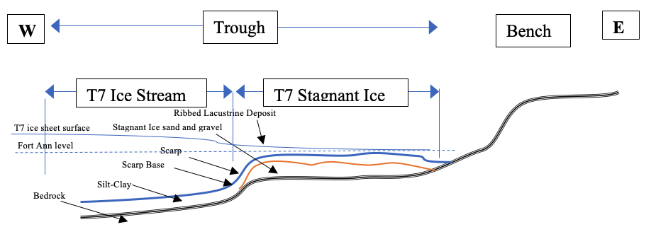
Scarps are believed to have formed, like “Lateral Shear Moraines,” at the margins between ice streams and slower moving ice, with Scarp bases close to but above the grounding line. Most Scarps are associated with physiographic benches, many identifiable as Ribbed Lacustrine deposits, which fits the boundary between fast- and slow-moving ice. Lateral Shear moraines are close to but slightly above and do not mark grounding lines. Lateral Shear Moraines as reported in the literature extend along the margins of ice streams and thus have longitudinal gradients. The gradients reported for modern ice sheets in Greenland and Antarctica tend to be very low, on the order of 1–10 m/km (5 -50 feet per mile). In Vermont, as noted above, Scarps occur at multiple locations all at approximately the same elevation when adjusted for isostatic rebound, close to but slightly above the Champlain Sea level. The question then is whether or not these Scarps in different locations, all occurred at the same time, or progressively through time as part of the northward ice margin recession. Whereas Scarps tend to be associated with the late T7 margin and in Fort Ann time, these markers themselves are diachronic. It is difficult to establish the timing of formation of Scarps in the Champlain history by the examination of Scarps themselves. However, other features identified in this 2026 re-examination, specifically Transverse Morainic Ridges, as discussed below, provide information suggesting the progressive northward, halting recession of the calving frontal margin.
Scarps and their associated Ribbed Lacustrine deposits mark a late T7 ice margin and are close to the level of Fort Ann, and thus as well formed in and represent Fort Ann time, representing the lateral shear margin of the Champlain lobe ice stream. The historical aspects of these features and streaming are discussed in detail in a separate section below. Whereas it is unknown whether the destabilization associated with Streaks was momentary or prolonged, the ice streaming indicated by Scarps is likely to have continued over a prolonged length of time, in an early phase of streaming, leading to an accelerated second phase of streaming. or perhaps a collapse(?). Again, detailed information about individual Scarps is provided in the field examination discussion below.
Footnotes