By way of background perspective, the deglacial record in the LaPlatte Basin is important as it provides substantial evidence about the recessional history of a re-entrant basin in the Middlebury Bench which is representative for all such basins. It also includes evidence reported by Wright, interpreted by him as marking a significant readvance, which is one of the key features which led to the pre-Addendum finding of a long convex Champlain Lobe at a late glacial time, prompting this Addendum study.
Interestingly, as previously discussed, in contrast, Calkin, who mapped glacial deposits in the nearby Middlebury area, including large portions of Little Otter Creek and New Haven River, both re-entrant basins, also recognized features suggestive of a readvance and debated alternative interpretations but concluded these more likely were related to oscillations associated with calving. As it turns out, Calkins thinking is similar to the results of this Addendum study albeit with an added ice streaming twist.
The screen shot below is taken from my VCGI map at a regional scale showing a substantial portion of the LaPlatte Basin:
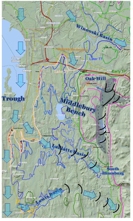
This map is intended to give an overview spatial physiographic perspective of the LaPLatte Basin and adjoining area, and the associated deglacial history:
- The T6 margin is designated by the violet colored line, which is here depicted schematically as an approximation for sake of simplicity. This margin is part of the step-down sequence from T3 to T7 times. The T6 margin represents a time when the Champlain lobe generally stood along the foothills but with ice tongues extending eastward into the major tributary basins such as the Winooski Basin to the north of the La Platte.
- The T6 margin was diachronous and receded northward and westward in T6 time, and was associated with Coveville Lake Vermont, which is not depicted on this map. Coveville occupied a narrow, more or less open water corridor along a “Disaggregated” type of ice margin in T6 time. Coveville likewise was diachronous. For example, a Covevile delta at Bristol formed from outwash from a T6 ice margin north of Bristol in the Starksboro area, just south of the map area. A Coveville delta at South Hinesburg, as shown on the map, marks the further northward penetration of Coveville waters in T6 time. The South Hinesburg delta represents a complex of four levels, including two upper local water bodies, the third Coveville level, and the fourth at the Fort Ann level. The Coveville delta at South Hinesburg was formed by drainage from Lake Mansfield 1 in the interior uplands.
- Further with regard to T6 time a substantial stagnant ice deposit, likely the most substantial of such deposits in Vermont, formed in the foothills as marked on the above map. LiDAR markings on this deposit, as depicted schematically on this map, show the northward and westward recession of the active ice margin fronted by stagnant ice, both together representing a hybrid type ice margin. This recession led to a T6 ice margin position with a spillway developed for locally ponded waters, with subglacial drainage beneath the Winooski lobe resulting in the lowering of Lake Mansfield 1 to Lake Mansfield 2. Drainage from this spillway extends to kame delta deposits west of the spillway in the Sucker Brook drainage, as reported by Springston and DeSimone (2007), at the Coveville and Fort Ann levels.
- The lowering of Lake Vermont from the Coveville to the Fort Ann level was both sudden and substantial, triggering destabilization of the ice margin in late T6 an early T7 time. This was associated with the transformation of the eastern margin of the Champlain lobe from a lateral toward a frontal type margin, as marked by Streaks at many locations in the Champlai Basin, as discussed previously. A set of Streaks on the north flank of Oak Hill on the above map mark this T6/T7 time destabilizatiuon. Further, this lowering resulted in the rapid recession of the ice margin allowing the entry of Coveville waters for the development of Ribbed Lacustrine deposits, including at the head of the LaPlatte Basin in the South Hinesburg area, and in the Winooski Basin south of Richmond and as well at the frontal tip of the Winooski lobe which at that time stood in the North Waterbury area.
- The early T7 time ice margin associated with the Coveville to Fort Ann lowering is marked by Ribbed Lacustrine deposits and kame deltas at the Fort Ann level in the LaPlatte Basin and Lewis Basins, as depicted by the solid green line on the above map. These mark the frontal positions of the LaPlatte and Lewis lobes.
- The destabilization of the Champlain lobe associated with the Coveville to Fort Ann lowering triggered calving of the eastern margin, in particular within the re-entrant basins in the Middlebury Bench where water depths were sufficient for calving. In contrast, the Middlebury Bench served as buttressing support for the Champlain lobe at this time.
- The frontal tips of the long, narrow ice masses within the re-entrant basins ice masses progressively receded by calving in a downgradient direction in T7 time, as marked by Ribbed Lacustrine, Kame Delta, and Thickened Bouldery Lacustrine deposits on the floor and side slopes of the re-entrant basins, as suggested schematically on the above map. Whether or not these narrow re-entrant basin ice masses were streaming at this time is unknown.
- The blue line represents a later T7 ice margin of the thicker ice masses within the re-entrant basins while the Middlebury Bench was still ice covered. In still later T7 time the ice margins stood at the mouths of the re-entrant basins along the margin of the Champlain Basin Trough, as designated by the bright pink line.
- This later T7 time when the Champlain lobe ice margin stood at the Trough margin represented a critical time. As stated in my pre-Addendum report I interpreted evidence as indicating that Fort Ann lowered to the Champlain Sea level at this time, associated with a readvance as marked by previously reported readvance evidence in the LaPlatte Basin by Wright, further south in the West Bridport area by Connally, and to the north in the Missisquoi Basin by Cannon and Wagner. This interpretation was part of the finding of a long convex Champlain lobe at a late glacial time. This interpretation was disproven by the Addendum findings which instead indicated further destabilization in late T6 and early T7 and associated streaming of the Champln lobe as marked by Scarps. These Scarps delineate a margin along the Trough, suggesting that the streaming likely was triggered by the loss of buttressing support at this time, again with the ice margin at this time marked by the bright pink line on the above map.
Returning to the LaPlatte Basin and the Addendum field evidence, the following is a screen shot map from my VCGI mapping at a larger scale on which details in the lower LaPlatte basin in the northern portion of the Middlebury Bench and along the eastern edge of the “Trough” are depicted
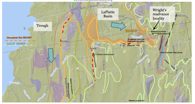
This screen shot is with the VCGI tab for Stewart and MacClintock’s surficial geology map turned on, with the purple shading indicating bedrock-controlled uplands in the Middlebury Bench, thin ground moraine and/or silt-clay ponded sediment cover as the olive shading, and the pale red shading as S & Ms’ stagnant ice kame terrace deposits along the LaPlatte (at the LaBerge Farm and along the LaPlatte just to the east). My VCGI mapping shows: a) the Champlain Sea marine limit by the orange line, b) the LaPlatte Champlain Sea delta by the ochre shading, c) the late T7 margin as marked by the pale yellow green line, and d) Scarps as marked by red dashed lines. Also shown on this map is the location of Wright’s readvance position, a nearby exposure at the LaBerge farm in the Champlain Sea deltaic deposit, and another location at a Scarp at the LeClaire farm. Still another Scarp is located further to the west in the Shelburne area. This last Scarp is on the corner between the Trough and the LaPlatte Basin in the Onset Zone for the Champlain lobe ice stream, as discussed below. Together, all these Scarps mark the late T7 time ice margin of the streaming Champlain lobe.
In my previous January 2026 report I identified a significant Ribbed Lacustrine deposit near the Town of Charlotte Old Town Dump, which is also marked on the map. This deposit has characteristic ribbing of Ribbed Lacustrine deposits, with an upper layer of silt and clay, and a buried stagnant ice core of sand and gravel, as identified in a well log and at an exposure on the LaPlatte. Stewart and MacClintock mapped this deposit as a kame terrace. In my pre-Addendum interpretation, this deposit was mapped by me at the T7 level and was thought to represent the end of Fort Ann time, closely associated with and followed by the lowering to the Champlain Sea, triggering a third calving event. The pattern of the LaPlatte makes a sudden, sharp turn to the west near this deposit, which was thought to indicate drainage control along the receding ice margin. Immediately to the west on the above map is the Champlain Sea delta (ochre color), as mapped by me in my 1972 report.
At the LaBerge farm, just a short distance to the west of Wright’s readvance locality, is an old, mostly slumped pit in the Champlain Sea deltaic deposit. Stewart and MacClintock mapped this as part of their kame terrace. This pit was revisited in 2025, prior to this Addendum, and found to be deltaic, but with coarse pockets of gravel previously interpreted as possible suggesting the close proximity of an ice margin. Further, the upper stratum is a laminated silt-clay layer, which is similar to the veneer on Champlain Sea deltas in the Missisquoi Basin where an upper silt-clay layer was also identified by Cannon (1964) and Wagner (1972), with interbedded till representing a readvance in that basin in my T8 time. Thus, again in my pre-Addendum report, I interpreted the LaBerge farm pit evidence as indicating a T8 margin in Champlain Sea time related to Wright’s readvance evidence. As stated above, this interpretation, along with readvance evidence at West Bridport, also in Champlain Sea time, was one of the stepping-stones leading to the concept of a long convex Champlain lobe with a readvance in T8 time. However, again the Addendum studies found that these features were formed as part of the ice streaming of the Champlain lobe in T7 time.
Regarding Wright’s readvance evidence, his description suggests that this deposit is in materials resembling deltaic deposits, at an elevation close to the Champlain Sea level. In my previous pre-Addendum report I interpreted this readvance as correlating with the nearby LaPlatte Champlain Sea delta and with the readvance evidence in the Missisquoi and West Bridport areas, again in T8 time and Champlain Sea time, with this margin marking a long T8 Champlain lobe.
This present Addendum of Scarps suggests that the late T7 ice margin likely extended as a lateral shear margin eastward along the dashed light yellow green line into the mouth of the LaPlatte basin in the Bench and as well southward along sloping western flank of the Trough. The sloping Trough flank is an obvious physiographic feature which fits conceptually with the eastern margin of the Champlain lobe as a shear margin. This shear margin is marked by many Scarps (presently 44 at the time of this writing and counting) throughout the Addendum map area, which formed in late T7 and Lake Fort Ann time. As noted above, the Trough ice mass lost the previous buttressing support of the Bench terrain, which triggered streaming of this ice mass in the Trough. Again, blue colored arrows have been added to the above map to indicate the main Basin Trough ice stream with an appendage into the lower LaPlatte. The northwest corner of the Middlebury Bench is regarded as part of the Onset Zone for this ice streaming.
The Scarp at the Patrick LeClaire farm has been examined in the field. The following map is a close-up from VCGI of this Scarp with LiDAR imagery turned on:
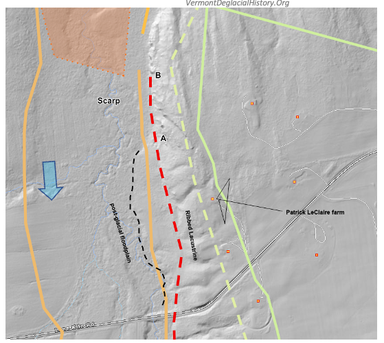
This Scarp is associated with and on the west flank of a suspected Ribbed Lacustrine deposit, with the ribbing strongly evident, and with the Scarp marking the western margin of the deposit. According to the landowner the surface soils in the vicinity are entirely silt-clay. However, excavations for a new septic system showed that these silt-clay soils in the vicinity of the farmhouse are about 4-5 feet (1.2 -1.5 m) thick, beneath which excavations showed a sandy or perhaps sand and gravel type soil. This finding is consistent with and supports the interpretation that this is a Ribbed Lacustrine deposit, in this area marking the late T7 margin. Whereas LiDAR imagery gives a sense of a possible Ribbed Lacustrine deposit with slight kamic topography, in the field the terrain of the bench top is non-descript, relatively flat, and gently sloping to the west, perhaps slightly rolling or undulatory but with no suggestion of kamic topography. The Ribbed Lacustrine deposit, like many of the locations identified elsewhere with Scarps, is a definite, pronounced bench, the Scarp being on the frontal edge of the bench. Again, the terrain is slightly undulatory, with drainage-like depressions associated with the Ribbing, but these are not marked by soil differences, being part of the silt-clay cover. It is possible that the terrain is very slightly constructional with kamic “dimples” but this would not ordinarily be recognized as associated with stagnant ice.
The frontal face of the Ribbed Lacustrine deposit, immediately west of the farmhouse, corresponds with the Scarp identified on LiDAR imagery. The terrain on the Scarp slopes steeply downward to the west, generally with no topographic evidence suggestive of ice presence. The base of the Scarp, which corresponds with the red dashed line on the above map, likewise corresponds with the juncture between the Ribbed Lacustrine frontal slope and the floor of the small basin occupied by the north-flowing LaPlatte tributary. The terrain west of this break in slope is relatively flat. Postglacial erosion associated with this small tributary has incised a shallow flood plain in the basin floor as can be seen on the LiDAR imagery, with the incision slightly lower and west of the Scarp base. To the north, the base of the Scarp, specifically along the red-dashed line from A to B, is a 30-40-foot-high bedrock cliff face (Monkton Quartzite), at the foot of which is a large mass of boulders and cliff talus. In one location is a small linear ridge, about 100-150 feet (30 – 46 m) long, and perhaps 5-10 feet (1.5 – 3 m) high and 30-50 feet (9 – 15 m) wide, but whether this ridge may be a Lateral Shear Moraine is uncertain. No exposures of subsurface soils were found anywhere along the Scarp base, but the ridge appears to be composed of till.
Based on this field study, in conjunction with the literature regarding shear zones, it is believed that this Scarp formed along a Lateral Shear Zone associated with the main Champlain Basin Trough ice stream and into an embayment at the mouth of the LaPlatte.
In his report for the Town of Charlotte Wright’s refers to an exposure he interprets as providing readvance evidence. This exposure was first examined in 2025, and was again revisited in 2026 as part of the field work associated with this Addendum. The exposure is located on a steep embankment on the north side of the LaPlatte River. Whereas his readvance exposure is about 10 meters above the river, there are numerous smaller exposures along the sloping terrain, at different elevations. These exposures show the surficial geologic stratigraphy in this area. The lowest exposures show a distinctive, cream colored light brown, very compact and dense glacial till, which is heavily laden with a colorful variety of rounded pebble size stones, and as well larger, rounded boulders, This till is very similar to the till identified by Wright in his report as a “Lodgement Till.” Wright, describes two types of till, one being a “Deformation till” and the other a “Lodgement till.” The following are Wright’s Figures 7 and 8 depicting his “Lodgement Till:”
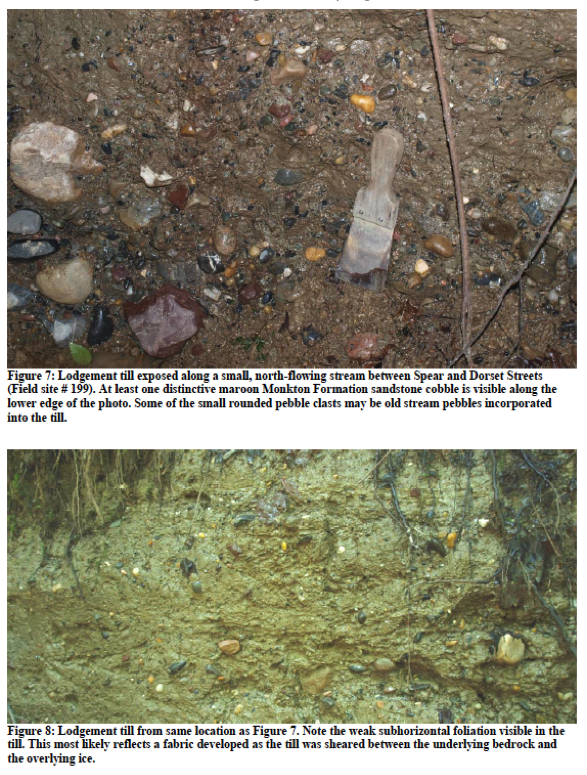
It is noted that in my experience and opinion this till differs from typical Vermont glacial till by the presence of many smaller sized, rounded pebbles. In my experience in mapping Vermont deglacial geology in the 1960s and 1970s this type of till is very unusual. Vermont glacial till typically consists of clasts which are widely varying in size, with angular shapes. Wright in his captions suggests that these pebbles may have been incorporated by the ice as it advanced over previous, older stream gravels.
In the text of his report, Wright describes the “lodgement till “ he observed in the Charlotte area as follows:
Lodgement till is a dense, unlayered diamict with grain sizes ranging from clay to boulders.Pebble, cobble, boulder density is high compared to the deformation till described above and this till frequently contains quite large (several meter diameter) erratics (Fig. 7). A weak subhorizontal foliation (fabric) is sometimes present and visible in rare fresh exposures (Fig. 8). Clasts within this till are sometimes angular, but frequently abrasion against adjacent clasts while the till was deformed (sheared) beneath the ice sheet and/or abrasion against bedrock has produced faceted and semi-rounded clasts. Lodgement till contains frequent erratics. In the western part of town Grenville gneiss erratics are particularly common in till whose matrix consists largely of disaggregated Ordovician shale and limestones. Those same shales and limestones are, respectively, partly or largely composed of calcite and consequently the lodgement till derived from these materials is very rich in calcite as well. Farther east the till contains more sandstone and dolostone reflecting the composition of the older Cambrian and early Ordovician rocks underlying this part of town.
Several aspects of Wrights’ description are of interest. The first is his observation of foliation which he interprets as shearing beneath the ice. Second, Wright recognizes the high limestone content which he attributes to Grenville formation material which outcrops locally in the western part of Charlotte in the area here identified as the “Trough.” Third, he attributes rounding of clasts to “shearing” within the till.
Whereas I have not specifically studied and mapped glacial till in my recent Vermont studies, as just noted above in my 2026 Addendum field work, I revisited the vicinity of Wright’s outcropping along the LaPlatte River where he specifically identified evidence which he interpreted as indication a readvance. I believe that this evidence is instead indicative of shearing along a lateral shear margin of the streaming Champlain lobe in Late T7 time. The following is a photograph taken from an exposure at the base of the embankment at a lower stratigraphic level below Wright’s readvance evidence:
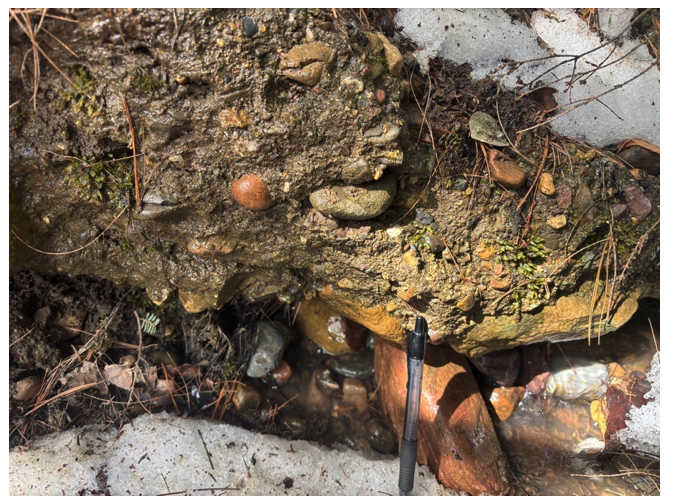
The pen provides a scale showing the sizes of the many rounded clasts within the till. It appears that this is similar to Wright’s description of his “lodgement till.” Also, at the same embankment but above the till are large blocks of highly cemented masses of sand and gravel containing pebbles which are similar looking, with similar lithologies.
In general, it is believed that the till at the base of this exposure corresponds with Wright’s “lodgement till,” which in my opinion formed along the lateral shear margin of the streaming Champlain lobe in Late T7 time. It is further believed that this particular till was formed in conjunction with the Scarp development, with the till produced by shearing in the vicinity of the lateral shear zone which as well caused the deformation in the overlying materials as reported by Wright.
As just noted, the presence of rounded pebbles in the till and the foliated nature as described by Wright are very unusual characteristics for lodgement tills in Vermont in my experience. In my field examination of Scarps at various locations as part of my April Addendum study I have noticed that many Scarps are associated with steeper slopes and commonly with shallow bedrock, likely part of shearing related erosion. Also, the terrain in these areas appears to be mantled by till and discontinuous lacustrine veneer but in some places exposures of the till are similar to the “lodgement till” identified by Wright. Further, erratics scattered on the terrain in Scarp vicinities in places are rounded stones, possibly providing another field mapping tool for the study and delineation of Scarps and lateral shear zones.
Thus, it is concluded, based on the entirety of the evidence from previous VCGI study and as well more recent study of the LaPlatte Basin, that the Wright “Deformation Till” exposure on the LaPlatte is part of the lateral shear margin in late T7 time, and not evidence for a T8 margin in Champlain Sea time, per my previous interpretation. This interpretation eliminates a major argument for ice presence as a long convex lobe in this area in T8 and Champlain Sea time, and as well fits with the findings based on many observations as presented in this Addendum for associated ice streaming as part of the collapse of the Champlain lobe triggered by the lowering of Lake Vermont to the Fort Ann level, again all in late T7 time.
The hillside above the till stratum at Wright’s readvance locality consists predominantly of bottom-set lacustrine material, with intermixed sand and silt layers, and with interbedded pocket-like deposits of other material, including large heavily cemented blocks of sand and gravel. Wright’s deformation evidence is in the upper portion of this stratum.
Exposures near the upper elevations of this same hillside indicate an uppermost third stratum of silt-clay at the terrain surface, which is also shown by Soil Conservation Service soil maps. At the top of the hillside, the terrain flattens, forming a bench. The terrain of this bench is irregular, perhaps slightly kamic, and is crossed by several swales which resemble those found on Ribbed Lacustrine deposits. The topography of this bench is not like a deltaic deposit and is at an elevation slightly above the Champlain Sea delta nearby to the west. Bedrock outcroppings further north indicate this bench is constructed of the above-described materials, as a Ribbed Lacustrine deposit, formed against a bedrock upland.
Owing to slumping, the exposure of the deformed strata identified by Wright is no longer visible. The following is a screen shot of this exposure, taken from Figure 6 of his report:
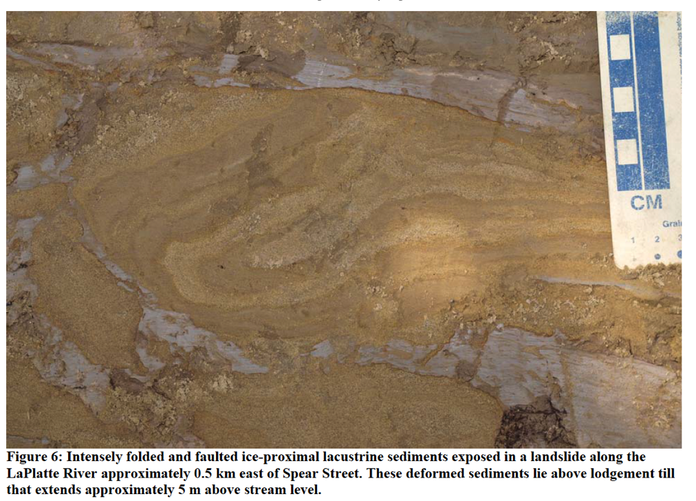
Whereas Wright interpreted this exposure as representative of a “Deformation Till,” which he regards as evidence of a readvance, neither the material in the photo in Wright’s report, nor the material observed in the exposure at this level, can be characterized as a “till,” but instead is consistent with deformation of strata with in the Ribbed Lacustrine deposit, at a lateral shear margin. In fact, Wright’s caption identifies this as “Intensely folded and faulted ice-proximal lacustrine sediments.”
Wright’s exposure is now believed by me to be part of a Ribbed Lacustrine deposit which correlates with the similar nearby deposit along the LaPlatte near the old Town Dump, associated with the late T7 margin. The elevation of the stratum in which the deformation is exposed is above the level of the Champlain Sea. Further, there is no topographic evidence in this Locale which would support the presence of the Champlain Sea delta. Most importantly, the deformation shown in Wright’s Figure 6 is consistent with the description given in the literature of Lateral Shear Zones. The deformation shown in Wrights Figure 6 is at a small scale as can be seen by the centimeter ruler, within the stratification of the lacustrine material. Whereas the three-dimensional shape of the deformed strata cannot be exactly determined from the two dimensional exposure, in general the deformation suggests shear from west to east, as would be expected in a lateral shear zone.
Thus, it is concluded, based on the entirety of the evidence from previous VCGI study and as well more recent study of the LaPlatte Basin that the Wright “Deformation Till” exposure on the LaPlatte is part of the lateral shear margin in late T7 time, and not evidence for a T8 margin in Champlain Sea time. This interpretation eliminates a major argument for ice presence in this area in T8 and Champlain Sea time, and as well fits with the findings based on many observations as presented in this Addendum for associated ice streaming as part of the collapse of the Champlain lobe triggered by the the loss of buttressing support of the Middlebury Bench, again all in late T7 time.