Interestingly, after my field work examining LiDAR evidence was concluded, as I was contemplating the historical meaning of such features, I recognized that the terrain in the Shelburne area , shown on the above map as part of a “pivot point,” related to the Onset Zone of the Champlain lobe ice stream. More detailed LiDAR study and field work in this area led to the identification of significant features believed to be related to this Onset Zone.
The map below gives a sense of the terrain and geological mapping in this area:
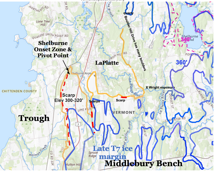
The solid blue line marks the late T7 ice margin of the Champlain lobe along the northwestern corner of the Middlebury Bench. The late T7 Champlain lobe predominantly occupied the Trough at this time. As described elsewhere, streaming of the Champlain lobe was triggered by the loss of buttressing support from the Middlebury Bench, as marked by Scarps. The bases of multiple Scarps are designated on the above map by the red dashed lines. The orange line marks the approximate Champlain Sea strandline at the marine limit. As can be seen, Scarp bases are close to but slightly higher than, above the Champlain Sea strandline. As noted elsewhere, the Scarps are interpreted as lateral shear margins of the Champlain lobe in. late T7 time, prior to the lowering from the Fort Ann level to the Champlain Sea.
A pivot point in an Onset Zone is marked. To the north of this point, the T7 Champlain lobe extended eastward into the LaPlatte and Winooski Basins, and to the southwest extended southward in the Trough. This Onset Zone is part of the necking of the Basin, meaning the Champlain Basin floor is wider to the north but narrows to the south, the Onset Zone being at the head of this constriction.
The following is a more detailed larger scale VCGI map of the pivot point area:
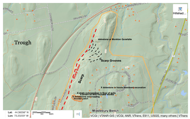
Again, the red colored line marks the base of a Scarp in this area . As can be seen curvilinears, referred to as “Scarp Grooves,” which are visible on LiDAR imagery, are marked by black dashed lines, as multiple, nested curvilinear “groove-like” linears in a shallow indentation, along the corner of the Middlebury Bench, to the west of which is the Trough, and at the base of which is the Champlain Sea marine limit strandline. Field mapping in this area suggests the presence of these linears as topographic bench-like irregularities but otherwise does not in any way give a sense of the presence of curvilinear features. Exposures on the floor of a small gully indicate shale bedrock, overlain by several feet of compact, light brown till with abundant small, rounded boulders, and in turn by 10-20 feet of lacustrine silt-clay with scatter rounded stone erratics. Natural exposures in several locations and a basement foundation excavation show that as is typically the case the Middlebury Bench in this area is capped by a dolostone, which is more resistant and durable than the shale which underlies the Trough.
Interestingly, just to the south of the indented area of curvilinears is a remarkable cluster of hundreds of rounded dolostone boulders, in an area perhaps with dimensions of about 100 feet (33 m) wide by 300 feet (100 m) long (the reddish colored area on the above map). Whereas early farmers in Vermont removed boulders from farm fields, in the process building stone and boulder pile walls along field margins, this particular cluster does not appear as a hedgerow pile. These boulders are believed to have been transported southward by ice shearing of the dolostone caprock from the indented area. The low, western margin of the boulder cluster is an area of broken up dolostone bedrock outcroppings. Likewise, dolostone and Monkton Quartzite outcroppings mark the rise in the terrain just to the north of the indented area.
The map below is a larger scale close up of VCGI LiDAR imagery of the curvilinears in this area, with the curvilinears marked by the dashed black lines and the Champlain Sea at the marine limit marked by the orange colored line.
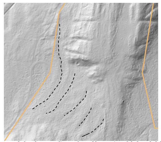
It is suggested that these curvilinears formed by erosion of shale and dolostone caprock in the Onset Zone along the lateral shear margin of the Champlain Lobe, and document the progressive lowering of the ice sheet to the Champlain Sea level, and that these features represent the triggering of a second phase of ice streaming caused by a) the opening of the Onset Zone in a manner which can be likened to a dam collapse associated with a change in the Champlain lobe’s mass balance, and b) the destabilization of the Champlain lobe associated with the sudden and substantial water level lowering from the Fort Ann to the Champlain Sea level. As discussed further below, the absence of Scarps in the northern Champlain Basin, north of the Onset Zone, is interpreted as indicating a second phase of accelerated ice streaming, and possibly the collapse(?) of the Champlain lobe.
As previously indicated a substantial literature exists regarding ice streaming and multiple associated Glacial Dynamics, including for example the warming of the ice sheet and presence of meltwater at its base, the nature of the substrate, and changes in buttressing support including by the terrain and proglacial water levels, and others. A second phase of accelerated ice streaming for the Laurentide ice sheet has been recognized elsewhere, as for example by Robel and Tziperman (2016), 1 Robel, A.A. and Tziperman, E. (2016) The role of ice stream dynamics in deglaciation; Journal of Geophysical Research: Earth Surface Volume 121, Issue 8 pp. 1540-1554 (https://doi.org/10.1002/2016JF003937)who suggest that the upward shift of the equilibrium line changes in the equilibrium mass balance associated with steepening of the ice surface and gradient in the Onset Zone resulted in accelerated streaming. Eyles, et al(2024) 2Robel, A.A. and Tziperman, E. (2016) The role of ice stream dynamics in deglaciation; Journal of Geophysical Research: Earth Surface Volume 121, Issue 8 pp. 1540-1554 (https://doi.org/10.1002/2016JF003937) who suggest that the upward shift of the equilibrium line changes in the equilibrium mass balance associated with steepening of the ice surface and gradient in the Onset Zone resulted in accelerated streaming. Eyles, et al 3 Eyles, N., Mulligan, R., Sookhan, S., et al. (2024), Laurentide Ice Sheet configuration in southern Ontario, Canada during the last glaciation (MIS 4 to 2) from stratigraphic drilling and LIDAR-based surficial mapping; Canadian Journal of Earth Science, V 61, Issue 10, pp 1076-1103. https://www.sciencedirect.com/org/science/article/pii/S0008407724000565?utm_source=chatgpt.com identify deep incised paleochannels in the western Ontario Basin for ice streaming, representing the growth and development of these channels over the course of multiple glaciations, and as well with evidence suggesting two phases of ice steaming in the most recent glaciation.