This Epiphany stemmed from a recent chance encounter with Paul Bierman at UVM, who provided me with a copy of a paper he recently co-authored with others. 1 This is a pre-print paper, dated July 29, 2024, entitled: In situ Cosmogenic 10Be and 26Al in Deglacial Sediment Reveals Interglacial Exposure, Burial, and Limited Erosion Under the Quebec-Labrador Ice Dome, which is available at the following online URL address: https://doi.org/10.5194/egusphere-2024-2233 In their report, the authors present findings from a study of beryllium and aluminum isotopes, documenting multiple Pleistocene glacial events over a long period of time. According to Paul, he and others are now planning a similar study of the Vermont Pleistocene. Thus, the Vermont deglacial history given here likely represents the “tip of the iceberg” so to speak, with the terrain modified by earlier glaciations. This same concept of longer term, multiple glaciations also is given by research reports in the Ontario Basin, including but not limited to the Finger Lakes region. For example, Bukhari et al, 2024, refer to “palimpsest” terrain, meaning that Late Wisconsinan glaciation did not necessarily construct the southern Ontario landscape de novo. Instead, the Laurentide Ice Sheet repeatedly inherited and modified pre-existing topographic and glacial surfaces, producing a palimpsest landscape in which younger ice-flow systems overprinted, but did not necessarily completely erase, older glacial terrain.
Bierman’s paper raises questions for me as to, 1) what took place in Vermont prior to the time represented by the findings given here, 2) where is this early record, and 3) what is the nature of this record, if any record exits at all?
The following sidebar represents my thoughts about Bierman’s findings and suggested possible lines of inquiry which may prove suitable for further study:
It is likely that evidence of earlier glacial times in Vermont, prior to the earliest ice margins as recorded by depositional evidence here, is represented stratigraphically by glacial till, and by erosional evidence, neither of which are examined in this VCGI study. In other words, in early glacial times when the ice lobe margins were still south of Vermont, the ice sheet in Vermont presumably was eroding the terrain and depositing till beneath the ice sheet.
With regard to glacial till, this gets to the issue of how and when during glaciation glacial till is formed, specifically lodgement type till, which is a larger topic beyond this VCGI study. However, the evidence as discussed in regard to the Ice Marginal Channels formed in T3/T4 time in association with the White Mountain Moraine System readvance suggests that these features were formed with warm basal ice in an inverted polythermal “sandwich,” and that this is represented by the till identified by Thompson et al as indicative of the readvance. This suggests that glacial till in the region may have been deposited by warm ice, as has been suggested in the literature, and as discussed above as one of my “epiphanies.” As such, it is possible, therefore, that the early part of the last glaciation in Vermont is recorded by older lodgement-type glacial till. Whereas, again, neither glacial till nor erosional evidence per se are specifically examined in this VCGI study, the evidence from this present study provides information bearing on earlier glacial times, where further study by isotopic analysis by Bierman’s methodology may be fruitful:
- Overdeepened Basins: As described above, the tributary basins in the Memphremagog Basin are over-deepened and occupied by deep lakes, with ice margins at the T3/T4 level similar to the Valley Heads Moraines similar to the Finger Lakes of New York. The origin or mechanism of over-deepening appears to be related to the ice flow in the Memphremagog lobe becoming constrained by the bedrock topography.
Likewise, the “Deep Lake” portion of the Champlain Basin floor represents an over-deepening, as depicted on a bathymetric map already given and discussed previously above. This over-deepening similarly may be caused by or attributable to the constraint of bedrock topography, by bedrock uplands on the Vermont and New York sides of the basin serving to constrain ice flow in the Champlain lobe. To underscore and emphasize the nature and significance of this over-deepening, the following is a portion of the previously shown bathymetric map for Lake Champlain:
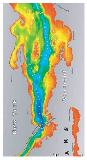
The over-deepened basin floor is illustrated by the dark blue colored shading. With regard to the southern end of the overdeepened trough, fundamentally this corresponds with a “necking” of the physiographic Champlain Basin floor, as can be seen on the following physiographic map, which likewise has been presented previously:
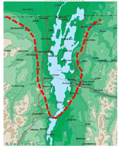
The red line appended to the above map marks the approximate boundary of a low ortion of the basement floor which fundamentally represents bedrock controlled terrain with only a relatively thin surficial cover veneer. The apex or “neck” of this basin “funnel” in Vermont is southwest of Vergennes, and in fact Thompson Point represents a bedrock projection which extends westward toward bedrock uplands across the Lake in New York, effectively representing a bedrock controlled physiographic basin threshold. And likewise, bedrock controlled Adirondack foothills mark the tightening “neck” of this funnel in New York. It is believed that this funnel caused ice flow to accelerate, although the over-deepened basin extends upgradient of the “neck,” which suggests complex physical flow dynamics.
Also as presented and discussed above, various researchers have identified, delineated suggested, or inferred ice margin positions in the Champlain Basin. For example, the maps below are from two separate reports by Franzi et al, the map on the left from Figure 2 in a report by Franzi et al, 2Franzi, D.A., et al, 2016, Post-Valley Heads Deglaciation of the Adirondack Mountains and Adjacent Lowlands, as modified from a previous report by Ridge , 2003. and the map on the right from Figure 3 in a different report by Franzi et al
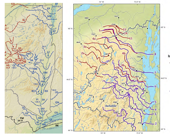
To be clear, whereas these maps show a close correspondence between ice margins and physiography, essentially in conformance with a “Bath Tub Model,” it is not suggested here that the ice sheet associated with these ice margins at the time of their formation had anything directly to do with the over-deepening per se. Rather, these margins are shown here onl to illustrate the close correspondence of the ice sheet to physiography. It is believed that the over-deepening was associated with late glacial streaming as discussed above, but alco may have occurred earlier, perhaps in fact caused by multiple glaciations over a long time such as recognized by Bierman. The above ice margins are seen as draped on pre-existing landscape, which likely formed over a much longer time period associated with the geomorphic history of the Appalachian (Green Mountain) and Adirondack Mountains, and the intervening Champlain Basin. In fact, the absence of a sediment bulge-like deposit on the basin floor immediately south of the neck on a scale corresponding with the over-deepened portion of the basin floor may be evidence that the over-deepening substantially developed at an earlier time, conceivably with little added deepening associated with the last glaciation.
The intent of the preceding is to make the point that the over-deepened floor of the Champlain Basin is glacial in origin and not fluvial. This observation applies to the entire “ Deep Lake.” Whereas isostatic rebound has served to flood the southern portion of the Basin, rebound has not fundamentally altered the fact that this “Deep Lake” portion of the Basin floor is a “closed” basin formed by glacial scour, the lower elevations of which are below present day sea level. Glacial over-deepening provides a reasonable explanation for the Deep Lake physiography which likely resulted in greater ice movement velocity, though the exact physical dynamics of this scour no doubt were complex. In fact, again the over-deepenings in the Champlain Basin and the Memphremagog Basin, closely resemble the Finger Lakes of New York.
Whereas published reports about the Finger Lakes suggest alternative explanations for the glacial formation of these overdeepened basins, these likely were over-deepened by ice scour, perhaps at multiple times in the past as suggested in the literature. Thus, these over-deepened basins might be favorable locations for further isotopic study by Bierman and his team. For example, the age of surface of the bedrock would reasonably seem to possibly vary with elevations in the floors and walls of these basins. Further, the till deposited to the south of these basins might provide a “shadow” enriched by “older bedrock” stones becoming progressively diluted in a downgradient direction, again in New York or the Vermont Valley. Conceivably this shadow may extend a long distance in the downgradient direction.
2. Roches Moutonees: In general, the larger topographic, mountain top scale elements of the terrain in both Vermont and New York show markedly asymmetric stoss and lee side topographic differences related to ice movement for both north-south and east-west profiles. For example, the profile of Adirondack terrain when viewed from the Vermont side of the Basin is distinctly asymmetric. My mapping in the 1960s and 1970s and again here with the VCGI mapping suggests that the Champlain lobe developed a rampart of till on the western slopes of the Green Mountains, in effect as a way for the ice sheet to more easily cross over the mountains in a southeasterly direction. And likewise, the eastern lee side of these mountains tends to be areas of shallow bedrock suggestive of plucking. For example, my older mapping showed this thick till “rampart” is on the order of 100 feet thick or more on the western flank of Mount Mansfield. Accordingly, this area may be a location where the Bierman team might explore isotopic age differences in the bedrock and till reflective of this history.
3. Scabby Terrain Patches: As described previously above, isolated patches of Scabby Terrain , particularly in the Memphremagog Basin, may represent areas of localized erosion associated with ice falls on the lee sides of bedrock knobs, as described by Davies and others in regard to “Disconnections. Again, these might be areas having age differences, particularly in bedrock and till on stoss versus lee sides of such knobs.
4. Step-down sequence of ice margins: This VCGI study indicates that the deglacial history of Vermont occurred in a progressive step-down sequence, with Ice Marginal Channels in the Nunatak Phase and progressively younger features at lower elevations including glacial and proglacial deposits associated with the Lobate Phase. This pattern of deglaciation corresponds with the observations reported by others, as for example Koteff and Pessel for southern New England, and has been observed by studies as referred to above in New Hampshire, Quebec, and New York. Such step-down deposits and features, which are very numerous in Vermont as identified on VCGI maps, might as well be locations where further isotope study might be fruitful, depending on the sensitivity of the methodology to short time differences.