The map below shows multiple recessional events beginning in late T6 and continuing in T7 time for the Champlain lobe:
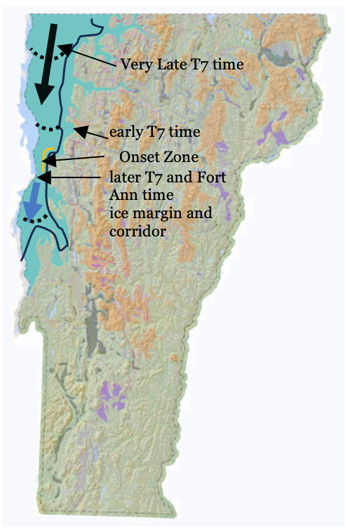
The position of the late T6 and early T7 time ice margin is depicted by the green colored shading, associated with the Coveville to Fort Ann lowering as a major triggering Glacial Dynamic event, resulting in destabilization of the Champlain lobe as marked by Streaks, and the transformation of its eastern margin from a lateral toward a frontal type margin, with calving at the heads of re-entrant basins in the Middlebury Bench, as marked by Ribbed Lacustrine and Headless Delta deposits on the walls of these basins and Thickened Bouldery Lacustrine deposits on the floors of these basins. Obviously, details of such features can not be depicted at this scale.
Again, as just stated, the lowering of Lake Vermont to the Fort Ann level led to:
- Destabilization of the entire Champlain lobe as marked by Streaks in late T6 and T7 time, along the perimeter of the Champlain lobe as depicted by green shading on the above map.
- Calving of narrow ice masses in the re-entrant basins in the Middlebury Bench in early T7 time, as marked by Ribbed Lacustrine, Headless Delta, and Thickened Bouldery Lacustrine deposits (not shown on the map)
- Clearing of the Middlebury Bench by recession of the calving re-entrant margins, with the Champlain lobe then standing along the Trough margin, as marked by the black line on the above map, resulting in the loss of buttressing support for the Champlain lobe, which triggered the first phase of streaming in the southern and central portions of the Champlain Basin, (heavy blue arrow), as marked by Scarps along the lateral shear margin of the ice stream south of the Onset Zone (orange colored line).
- Subsequent clearing of the Onset Zone and lowering of Fort Ann to the Champlain Sea level in later T7 time triggered a second phase of accelerated streaming of the Champlain lobe as suggested by the heavy black arrow, as “marked” by the absence of Scarps in the northern Champlain Basin and by erosional grooves in the Onset Zone, by which the Champlain lobe receded from the basin in Vermont. This second phase of accelerated streaming may represent the Champlain lobe “collapse(?).”
- Bouldery lacustrine and marine deposits on the Champlain Basin floor, which are mapped northward to the Quebec border, suggest that this streaming recession was also associated with calving, as depicted schematically by the arcuate dashed black lines on the above map.
All of this history, of course, represents significant Glacial Dynamics between the ice sheet and both the terrain and the associated water bodies. Again, it is noted that the absence of Ice Marginal Channels associated with the Champlain lobe in T7–T8 times indicates that by this time the Champlain lobe, had become warmed, such that Ice Marginal Channels could not form. This warming of the Champlain lobe was one of multiple Dynamics which also was associated with meltwater at the base of the ice sheet. This Dynamic led to ice streaming and perhaps the eventual “collapse(?)” of the Champlain lobe in Vermont.
During the course of T7 time, the “Disaggregated,” more or less open water corridor extended progressively northward in Fort Ann time, by which the Champlain lobe became increasingly convex, unstable, and unsustainable, in accordance with Franzi’s (2026, personal communication) examination of theoretical ice sheet profiles. Of course, this interpretation suggests that this corridor extended into Quebec in conjunction with the opening of the Basin for the incursion of the Champlain Sea.
The northward progression of the Fort Ann corridor in T7 time is marked by many deposits and associated evidence along the eastern margin of the Champlain lobe. For example, immediately to the north of the mouth of the Winooski in the Essex area, the T7 margin is associated with two eskers with drainage graded to the Fort Ann level. By itself this observation indicates the ice margin presence in Fort Ann time and implies that Covelle was restricted to the southern portion of the Basin, generally south of the Burlington area. The T6/T7 margin in this area marks the southern end of an ice margin drainage complex extending northward in the foothills, including the Indian Brook Reservoir, Colchester Pond, Milton Pond, and extending northward to Streaks at the mouth of the Lamoille Basin, and beyond. This complex is characterized by multiple long, narrow ridges and intervening ravine-like drainage ways. These were previously thought to represent surface water drainage along the ice margin. However, field mapping as part of this Addendum failed to document the presence of gravel on the floors of these ravines. Instead, multiple exposures along this complex suggest the presence of a distinctive till characterized by numerous rounded boulder to pebble size erratics. This type of till was identified in the LaPlatte Basin as being part of the lateral shear margin of the Champlain lobe. Thus, this complex likewise may represent the lateral shear margin of the Champlain lobe, with drainage materials at the base of the ice sheet becoming sheared into and incorporated in till. It is believed that this drainage may have contributed to the major T6 stagnant ice deposit just south of Williston.
North of the Lamoille, the lateral margin of the Champlain lobe in T7 time is marked by Bedrock Grooves indicating substantial southward drainage of meltwater along the lateral margin of the Champlain lobe, again as part of a step-down sequence in T4 -T7 times leading to Fort Ann kame delta deposits, as for example at Bakersfield. The Shattuck Mountain Pothole Tract is a spectacular part of this drainage, indicating enormous volumes of meltwater, some of it likely originating on the ice surface, penetrating to the base of the ice sheet. Clearly, increasing volumes of meltwater were being generated in T6 and T7 times, all of which somehow and in in some way had to make its way southward, along, within, and beneath the ice sheet margin, finding its way southward eventually and ultimately into the Lake Vermont drainage outlet system. This represented drainage of meltwater along a huge portion of the Champlain lobe, likely including parts of Quebec. Added to this was meltwater from Lake Iroquois in the Ontario Basin on the New York side of the basin at the time of its “breakout”, and interior Winooski/Lamoille Basin drainage associated with proglacial Lakes Mansfield, both likely in T7 time. These added meltwaters from Lakes Iroquois and Mansfield likely increased the load of warmed meltwater, serving to further hasten Champlain lobe recession.