The pre-Addendum findings for the early part of Vermont deglacial history represent a time referred to as the “Nunatak Phase,” which generally comports with a broad range of elevations in T1 -T3 times, with the “Lobate Phase” beginning in late T3 time. Late T3 time is shown on the following map:
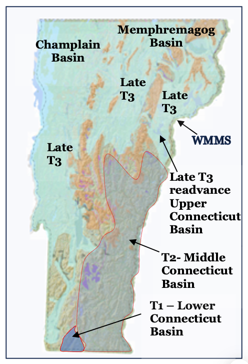
This map depicts the late T3 time ice coverage by the green colored shading, again at the end of the Nunatak Phase and beginning of the Lobate Phase, associated with a readcance. The ochre-colored areas represent nunataks in late T3 time.
The Nunatak Phase is marked by numerous Ice Marginal Channels which are mapped on VCGI Project Sheets but not correlated. As discussed, Ice Marginal Channels represent a significant Glacial Dynamic related to the warming of the receding outer fringe of the ice sheet’s basal ice, and mark the progressive lowering of the ice sheet in the Nunatak Phase. Again, the Ice Marginal Channels, while not correlated, are so numerous as to give a pictorial sense of the growing expansion of nunataks associated with recession of the ice sheet through the Nunatak Phase, leading to the development of discrete ice lobes in the subsequent Lobate Phase.
The gray colored areas in the lower and middle Connecticut Basins on the above map represent Disconnections in T1 and T2 times, marked by the absence of Ice Marginal Channels and the presence of Scabby Terrain tracts, and representing en mass stagnation, again at T1 and T2 times in the Nunatak Phase. These en mass stagnations are an expression of Glacial Dynamics between the ice sheet and the terrain resulting from the lowering of the parent ice sheet in the Champlain and Memphremagog Basins such that ice supply across cols into the Connecticut Basin ceased, first in T1 time and subsequently in T2 time.
Discussions with Etienne Brouard and David Franzi, in early 2025/2026 provided helpful information for Quebec and New York. In general, it is here suggested that the Vermont T3 Nunatak Phase Ice Marginal Channels correspond with similar deglacial features and history in New York and Quebec, the latter as marked by Ice Margin Channels in a phase identified by Cormier et al (as discussed below), generally before the “Memphremagog Readvance.”
Again, late T3 time represents a significant readvance of the ice sheet in the Upper Connecticut Basin, correlated with the White Mountain Morainic System (WMMS). As reported by Thompson et al this readvance is dated at about 13,800 – 14,000 years BP and was associated with a time of global cooling, and thus is not an expression of a Glacial Dynamic. This ice mass subsequently became Disconnected in late T3 and T4 when recessional lowering of the ice sheet terminated flow across col divides from the Champlain and Memphremagog Basins into the Upper Connecticut Basin time, entailing the third en masse stagnation.
As discussed, I have pondered and studied Ice Marginal Channels at great length, and as previously indicated have concluded that these formed: 1) at the base of the ice sheet in active ice, 2) where and when the basal ice at the ice margin had become polythermally warmed, 3) with a Warm surface later ice overlying an intermediate Cold ice layer and this in turn overlying a Warm basal ice layer, essentially as a multilayered, polythermal condition, 4) specifically along an outer fringe portion of the ice sheet margin, 5) allowing for the free flow of meltwater beneath the ice sheet and within basal ice fractures, 6) such that meltwater at the base of the Warm marginal fringe of the ice sheet became vertically hydrostatically confined as a discrete hydrogeologic flow system, 7) by the overlying Cold ice layer. 8) behind protuberance irregularities in the bedrock controlled terrain, 9) whereby Ice Marginal Channels formed by erosion along the lateral margin of Cold basal ice, 10) specifically at these protuberance subglacial “dams,” 11) in a manner analogous to surface water spillways at basin divides but in this case for water within and beneath the ice sheet basal ice, 12) with Ice Marginal Channels thus effectively representing “spillway-like” channels, 13) and finally, with this pattern occurring recurrently as deglaciation proceeded, with multiple Channels occurring in vertically nested flights, again at such terrain protuberances.
Thus, Ice Marginal Channels represent an important Glacial Dynamic and Style, again relating to early basal ice warming and meltwater presence along ice sheet margins.
As just stated, Ice Marginal Channels generally are absent in the lower and middle Connecticut Basins, but are identified and mapped in the Upper Connecticut Basin. Their absence in the Lower and Middle Connecticut Basins is an important Glacial Dynamic clue, indicating the absence of active ice related to progressive Glacial Dynamic “Disconnections” of discrete ice masses in the Connecticut Basin, which again took place at three times and places. Such Disconnections are marked by Scabby Terrain, a deposit marked by peculiar and distinctive LiDAR features.
Late T3 Ice Marginal Channels in the Memphremagog Basin at an elevation of 1400 feet (427 m), near the Quebec border, and near the end of the Nunatak Phase and beginning of the Lobate Phase, occur in close association with stagnant ice deposits at an elevation of about 1200 feet (366 m), and together these margins are interpreted as a “hybrid” T4 margin marked by both active and stagnant ice features, respectively. All Lobate Phase ice margins are believed to be hybrid margins. The active versus stagnant ice margin components of hybrid margins receded at different rates, which also represents a Glacial Dynamic. The active ice margin component is marked by Ice Marginal Channels, Bedrock Grooves, and other such active ice features, which by their nature indicate that they formed along Cold, hard, solid, active ice capable of restraining and impounding meltwater water. This is in contrast to Warm stagnant ice margins, which are completely penetrated by crevasses, allowing for the penetration and drainage of meltwater.
Owing to their insulating sediment cover, stagnant ice margins were longer lasting than their active ice margin Hybrid counterparts. As described in my pre-Addendum findings, this difference resulted in a “dance” between active and stagnant ice margins, with active ice margins receding to new lower and younger ice margin positions, while their stagnant ice component remained. Drainage features are graded from the older, higher, longer lasting stagnant ice margins to the next younger, lower active ice margins, with diversion of this meltwater along the younger active, Cold ice margins. This “Dance” is described and referred to as “Everything, Everywhere, All at Once, and Continuing” to underscore this complexity. This Style represents a Glacial Dynamic. Again, all T times and associated margins in the Lobate Phase are regarded as hybrid ice margins, which adds to the complexity of the deglacial history.
Ice Marginal Channels and stagnant ice deposits associated with the Late T3/T4 hybrid margin extend across divides at cols between the Lamoille and Upper Connecticut Basins and similarly across divides between the Memphremagog and Upper Connecticut basins. These represent an ice margin which can be traced southward in the Upper Connecticut Basin, defining an active lobe in this basin with a lobe tip near Bradford, with an outwash plain which is graded to Lake Hitchcock. These same ice marginal features are correlated with the White Mountain Morainic System identified on the New Hampshire side of the basin, as reported by Thompson et al. Thus, the late T3/T4 margin represents a readvance as reported by these authors. This late T3 and early T4 margin is here correlated with the Frontier moraine in Quebec, which is made more plausible by the orientation of isobases. The extent of the recession prior to the readvance in Vermont is unknown. Again, as reported by Thompson et al this readvance was associated with a climatic cooling and thus does not represent a Glacial Dynamic.
Still further, as previously suggested, late T3 and early T4 time Ice Marginal Channels and associated stagnant ice deposits mark a “Signature” which facilitates the correlation and mapping of this ice margin across Vermont, independently supporting the usage of the Bath Tub Model. 1 As previously noted, Streaks and Scarps as well represent “Signature” markers. These late T3 and T4 features thus represent a significant statewide readvance at the beginning of the LoAs previously noted, Streaks and Scarps as well represent “Signature” markers.bate Phase, for which supporting correlative evidence is identified in the Winooski Basin and the Vermont Valley, again as discussed previously.
For me, the recognition that the entire deglacial recessional history of the Lobate Phase in all of Vermont follows a significant readvance at such a late time has been a remarkable, surprising finding. This indicates that most of the deglacial history reported here occurred at a late time.
[1] As previously noted, Streaks and Scarps as well represent “Signature” markers.