In my original, initial report, as discussed above, which was “finalized” in January 2026, I found that the Champlain lobe persisted as a long convex lobe in T7 and Fort Ann time, continuing into late glacial T8 time, with a readvance in T8 time following the incursion of the Champlain Sea. This interpretation was based on diverse evidence, including the correlation of readvance evidence reported by Wright (2009) in the Charlotte area and Connally (1970) in the Bridport area, with readvance evidence in the Missisquoi Basin in Champlain Sea time, as reported by Cannon (1964) and Wagner (1972). The correlation of these readvances, plus other correlative information resulted in a long convex late glacial lobe in both T7 and T8 time. Whereas Bridport is located in the southern part of the Champlain Basin, giving this this long, convex shape, the readvance was believed to have been relatively limited and minor, with both Fort Ann and Champlain Sea waters occupying a narrow, more or less open water corridor along the T7 and T8 ice margins of this long convex lobe.
As discussed in the pre-Addendum report, the concept of a long convex lobe with a late glacial readvance at such a late time evolved progressively, almost reluctantly, as a matter of fitting together multiple pieces of evidence. As was recognized, this finding flies in the face of conventional thinking about the configuration of the receding ice margin as a flattened, calving lobe, as suggested by Chapman and many other subsequent researchers, with the ice margin in Champlain Sea time commonly thought to be located north of the Quebec border to allow for the incursion of the Sea. Of course, as was also noted, until this present study the positions of the ice margins in Vermont have been inferred, based on an assumed preconception about the nature of the Champlain lobe and its recession in relation to proglacial water levels, as part of the then prevailing paradigm (unrecognized as such), but not directly and explicitly based on actual ice margin evidence. The evolution in my thinking and associated evidence leading to the long lobe interpretations is described in the pre-Addendum January 2026 report above and is not repeated here.
Discussions with David Franzi near the end of my study about such a long late glacial lobe were helpful. David expressed skepticism about the presence of a long convex lobe and readvance at such a late time based on evidence in the New York side of the basin and as well on published theoretical profiles for receding ice sheet lobes which suggest to him that such a long convex lobe, especially a readvance at such a late time, is physically unsustainable. My response to David was first in regard to the New York evidence that I believed the lobe was “schizophrenic,” with the recession on the New York side of the basin being very different from the Vermont side owing to physiographic differences which promoted earlier and more substantial calving on the western side of the basin. And second, I suggested that in regard to his profile argument, the presence of a long late convex lobe may have reflected the lingering presence of ice from its former more substantial extent. And I speculated that perhaps this lobe may have been mostly stagnant with oscillatory spasms or pulses to account for the “readvance” interpretations reported by Connally and Wright as part of the long late convex lobe interpretation. I even found literature identifying such spasms in otherwise dead ice which fit with this thinking. Obviously, I was doing my best to both accommodate David’s thinking and arguments, while clinging to my long lobe interpretation, in respect to the accumulated evidence in support of this interpretation.
David provided me a report that he recently published,1Franzi, David A., Sean Grasing, Emily McLean, David Barclay, and Jason Briner.“Bridging the Gap: Glacial Geomorphic Mapping in the Adirondack Upland, New York.” Geological Society of America Abstracts with Programs, Vol. 58, No. 2 (2026).DOI: 10.1130/abs/2026NE-12821. showing the configuration of moraines and other features documenting the progressive recession of the ice margin and the associated development of proglacial water bodies in northwestern New York. It is interesting to note that this report is based substantially on LiDAR imagery. It strikes me that just as the usage of such imagery in Vermont for me has revolutionized the way we look at deglacial history, Franzi et al’s report likewise shows the benefit of LiDAR. Whereas the specific types of ice margin features differ from those found here in Vermont, in general a similar step-down recession is indicated. Franzi et al identify a major end moraine, referred to as “Covey Hill-Ellenburg-Plattsburgh Ice Margin (CHEP)” which wraps around the terrain showing an ice lobe occupying the Ontario Basin and extending southward in the Champlain Basin. As discussed in the Appendix, Franzi has provided me with several reports that document the presence of multiple receding lobe ice margins in the Champlain Basin, which I used to get a sense of possible correlations with receding T margins in Vermont.
Significantly, Franzi,Carl, Pepperstone, and Gordon, 2023, 2 Franzi,D., Carl, B., Pepperstone, H. and Gordon, C. 2023, NEW INSIGHTS INTO THE INTERRELATIONSHIPS BETWEEN LATE PLEISTOCENE–Early Holocene proglacial lake and marine water bodies in the St. Lawrence and Champlain valleys in New York, Vermont, and adjacent Canada, GSA Abstract Joint 72nd Annual Southeastern/ 58th Annual Northeastern Section Meeting – 2023, Paper # 44-1. indicate that the “breakout” of Lake Iroquois in the Ontario Basin into the Champlain Basin was associated with, and in fact triggered the lowering of Lake Vermont from the Coveville to the Fort Ann level, with the ice margin then standing at Covey Hill. Franzi, et al 3 Franzi, D. A., Ridge, J. C., Pair, D. L., DeSimone, D. J., Rayburn, J. A., & Barclay, D. J. (2016). Post-Valley Heads deglaciation of the Adirondack Mountains and adjacent lowlands. Adirondack Journal of Environmental Studies, 21(1), 119–146. provide illustrations depicting the ice margins in the Ontario and Champlain Basins in Coveville and Fort Ann times.
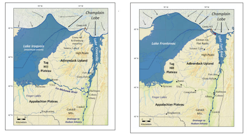
According to Franzi (2025) personal communication) he believes that the ice margin in the Champlain Basin in Fort Ann time was flattened by calving, resulting in the ice margin in subsequent Champlain Sea time standing further north in Quebec. Further, he indicates that the depiction of this flattened lobe extending across the basin into Vermont is schematic.
Also, discussions with Etienne Brouard were likewise helpful. Brouard provided me with a recent report he co-authored (Cormier, et al.,4 Cormier, M.-A., Lajeunesse, P., Brouard, E., & Bernier, J.-F. (2025). “Revisiting retreat patterns of the Laurentide Ice Sheet margin during the Late Pleistocene in southern Québec using LiDAR imagery.” Geoscience Canada, 52(2), 119. DOI: 10.12789/geocanj.2025.52.223. stating:
“Since the 1800s, the deglaciation record has been investigated mostly by mapping of surficial deposits and landforms from air photo interpretation and field observations. The deglacial patterns and its dynamics in the Appalachian and St. Lawrence lowlands sectors are still poorly understood today, due to the limitations of these previous approaches in a dense forest cover.”
Their findings show the benefit of LiDAR and recognize the importance of Glacial Dynamics, as for example a distinction between Cold versus Warm based ice. The authors recognize step-down recessional ice margin positions as depicted by various moraines formed in close association with proglacial water bodies, in contrast to climatically driven readvances. According to Brouard (2026, personal communication), the evidence in southern Quebec may be compatible with a narrow, open water corridor along the receding ice margin leading to the lowering of Lake Fort Ann and the opening of the basin for the incursion of the Champlain Sea, supporting the concept of a long convex Champlain lobe in Fort Ann time.
In any case, the finding of a long, convex lobe at such a late time was uncertain and, so to speak on “thin ice,” and deserved to be re-examined. The above January 2026 report was completed with the issue regarding the nature, shape, and extent of the receding Champlain lobe in T8 time left unresolved. Thus, I subsequently decided to take a closer look at this issue, first by more detailed study of VCGI map evidence, especially using LiDAR imagery, followed by focused field examination of selected critical features. This Addendum summarizes these findings.
The Addendum study showed that the previous findings of a long, convex Champlain lobe in T7 and T8 times was incorrect. Instead, Addendum findings indicate a long convex lobe in late T7 time and Fort Ann time in Vermont, with calving and streaming in two phases, with accelerated streaming in the second phase, perhaps as a collapse(?) of the Champlain lobe, followed by a readvance in T8 time limited and restricted to the Missisquoi Basin. This interpretation resolved the issue raised by Franzi, albeit in an unexpected way.
Whereas the pre-Addendum findings for much of Vermont and the deglacial history prior to T7 time have not been changed by the Addendum and remain valid, it is helpful to summarize the now revised understanding of entire Vermont deglacial history. Thus, the text below provides a summary of the now revised findings of this report for the full deglacial history of Vermont.
This entire study for me has been a learning experience, in a sense with multiple epiphanies. In my Preface I offered a comment about epiphanies and paradigms, which bears repeating:
“This is the story of the deglacial history of Vermont, across the entire State, including suggested possible correlations with neighboring Quebec, New York, and New Hampshire. This has never been done before. For me, my revisit was a “voyage of discovery,” poetically speaking, finding new information, with many “epiphanies.” These epiphanies represented “a ha” moments when I suddenly understood and grasped the meaning of certain evidence. And further, these epiphanies morphed into a new paradigm understanding of Vermont deglacial history. Recognizing the need to document the basis for my findings in detail as factual evidence as my voyage progressed, I was forced to write, not knowing where this exploration was taking me. As a consequence, this report became overly long and needs to be condensed into a summary of its essence. But the details given provide documentation of the basis for my findings in this present version for the benefit of future researchers.
I refer to “paradigms,” which are powerful ways of processing information, at the very heart of human thinking. But at times our paradigms limit our ability to see and understand what is before our eyes, becoming so-called paradigm “traps.” It turns out that satisfying my curiosity required imagination to explore the evidence I was finding, hence the quotes on the frontispiece of this report. These quotes are not intended to signify that others before or after me in the 1970s lacked imagination. Rather, they serve to remind me that my personal lack of imagination was a failing. Back then, in the old days, I could have done a better job, if only… ! But, of course, it’s always easy to look back. For me, my “a ha” epiphanies thus led to a “paradigm shift,” a new and different understanding of Vermont deglacial history.
I think of my entire research experience as very much like solving a gigantic three-dimensional puzzle in which some of the puzzle pieces are missing and many need to be carefully studied to be understood, with time as an additional part of the puzzle.”
One of these epiphanies referred to has to do with Glacial Dynamics. It turns out that the Addendum study showed that Glacial Dynamics played a major role in the late times of the Champlain lobe. Thus, a discussion is added about Glacial Dynamics.
Finally, as the Addendum study progressed it became increasingly clear that the Vermont story needs to be told in a broader regional context, and accordingly a discussion is added about the regional perspective.
Organizationally, this Addendum includes the following:
- LiDAR imagery findings
- Results of follow-up focused field work
- A summary of the Addendum findings in the southern and central Champlain Basin
- Revised deglacial history of the entire State of Vermont
- Glacial Dynamics Epiphanies
- A regional perspective
Footnotes