At various locations scattered around Vermont are elongate linear or curvilinear features on the terrain as evident on VCGI maps, usually enhanced by LiDAR imagery. These generally are in shallow bedrock terrain with thin till ground moraine or lacustrine of marine silt-clays. Whereas these linears may simply reflect bedrock structural elements, such as foliation or schistosity, or in some cases be associated with strandlines, it is believed that some of these relate to ice margin positions. In some places these show deposits suggestive of more granular materials, as for example documented by the surficial geology and soil sewage favorability tabs on VCGI. These linears are marked on VCGI maps, as Ice Margin Lines.” Owing to the uncertainty regarding their origin and significance, these features were not used in the identification of ice margins.
“Ice Margin Lines” northwest of Snake Mountain are of particular note. The following are screen shots of the area, taken from VCGI, on the left with the LiDAR tab turned on but no markings, and on the right from the VCGI Project Sheet:
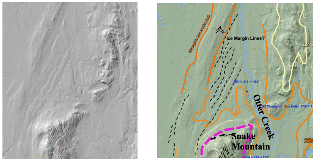
- The dashed black lines on the right image mark the Ice Margin Lines
- The maroon line = the T6 ice margin near the base of Snake Mountain. Again, early T6 time was associated with Coveville and late T6 time with Fort Ann, including the development of a calving margin in the Middlebury Bench
- The yellow lines = the 400 foot(122 m)elevation topographic contour, drawn to get a better sense of the physiography
- The orange lines = the approximate Champlain Sea marine limit.
It needs to be said that a closer examination of the area of these Ice Marginal Lines(?) on LiDAR indicates substantial information which is as yet not understood. For example, Lidar imagery suggests possible outwash fans(?) associated with the westernmost ridge, which is consistent with literature for for calving ice margins of present day ice sheets. Sewage soil favorability maps on VCGI show textural variations with a linear pattern of more granular soil on the west flank of the same westernmost ridge. Both of these observations might somehow be associated with a calving margin grounding line. However, other interpretations are possible. For example, the more granular soils might instead be associated with the Champlain Sea strandline and have nothing to do with an ice margin presence.
The geologic origin of these features at the time of the pre-Addendum study was uncertain. Of course, they may be bedrock controlled with no glacial significance. However, neither the State Surficial Geology Map, nor the sewage favorability tab on VCGI, give any indication of shallow bedrock. The soil sewerage favorability tab shows no variability of soil surface textures, suggesting that the linears likely are not postglacial erosion in origin related to bedrock structural fabric. It is not believed that they are physiographic expressions of bedrock structure, enhanced by glacial actions. The State Surficial Geologic map shows that the surface soils in the area of the Ice margin Lines are bouldery silts and clays, which would be consistent with a calving mechanism. No information is given as to whether these are lacustrine or marine in origin, though the fact that they are below the marine limit, suggests the latter.
The Ice Margin Lines at this location resemble and may be “Mega-scale Lineations”(MSGLs) or “Grounding Zone Wedges. ” As described above, MSGLs are elongate linear elements on generally flat topography associated with fast moving ice streams at calving ice margins, with the linears thought to be impressions caused by the weight of fast moving ice in ice streams on underlying soft sediment, typically soft, deformable till. Thus, MSGLs form at the grounding line of calving ice margins, oriented parallel with ice streaming.
In the Addendum study, the Ice Margin Lines at this location were determined to be “Mega-scale Lineations”(MSGLs). MSGLs are elongate linear elements on generally flat topography associated with fast moving ice streams near to but slightly upgradient from grounding lines of calving ice margins, with the linears thought to be impressions caused by the weight of fast moving ice in ice streams on underlying soft sediment, typically soft, deformable till.
MSGLs dimensions typically are :
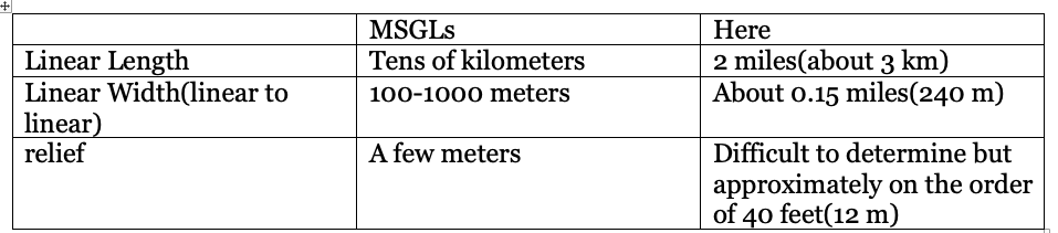
Thus, the Vermont features are shorter than typical MSGLs, comparable in width, but much deeper.
The following screenshot from VCGI shows a larger area around the linears:
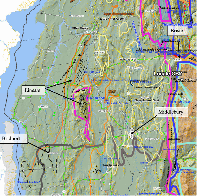
The location of the linear features near Snake Mountain and the Bridport area are identified. The orange colored line represents the marine limit, as drawn by Chapman and Wagner(1972) and as well by Springston and Wright. And the heavy dark gray line marks the boundary of the bouldery soils. As can be seen, the linears are basically at or near the marine limit near Snake Mountain, at the mouth of Otter Creek. As such, if these linears were formed as calving ice margin features at the calving line, as for example as grounding line wedges, they would support calving of the long convex lobe in T8 and Champlain Sea time as suggested in the pre-Addendum report.
As can be seen on the above map, Ice Margin Lines are also identified on the eastern flank of Snake Mountain. As discussed previously, these may represent portions of Ice Tongue Grooves similar to features identified at the mouths of the Winooski, Lamoille, and Missisquoi Basins.
Ice Marginal Lines are also identified on the floor of the Missisquoi Basin near the Quebec border:
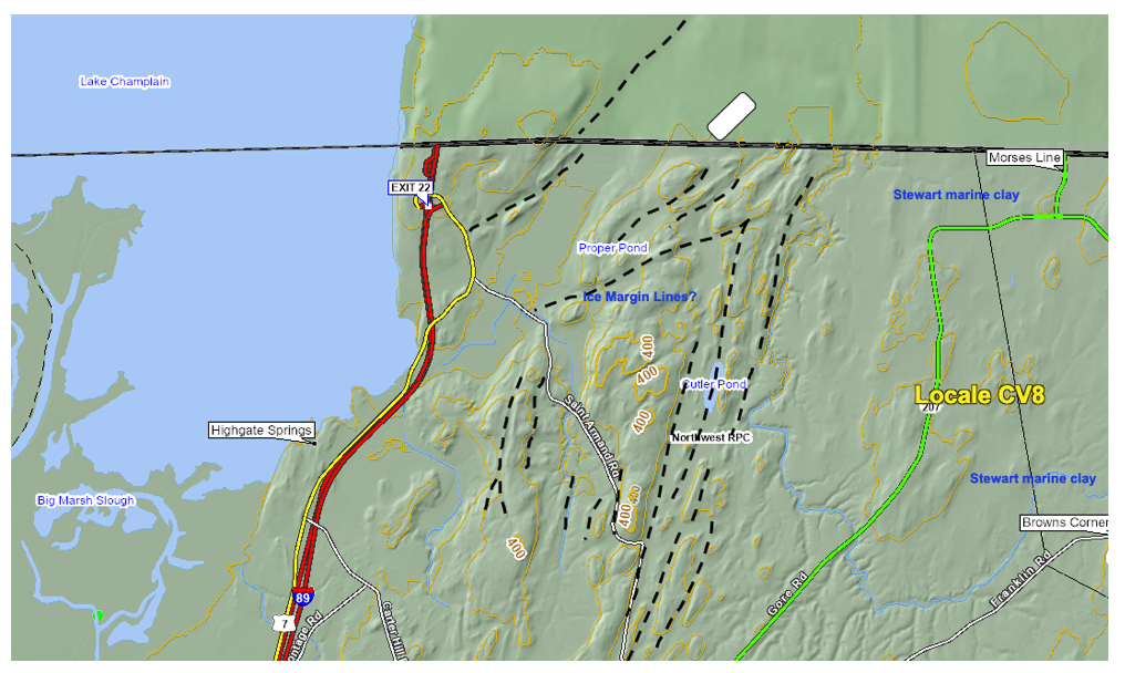
Again, the significance of these features, if any, requires further study. It is apparent that many of the ridges which are part of these Ice Margin Lines are marked by shallow bedrock, and the troughs between these ridges are floored by marine silt-clay, some but not all of which is identified as “bouldery.” However, scattered along the floors of these troughs in some places are gravel deposits which Stewart and MacClintock interpreted as “beach gravel.” VCGI LiDAR imagery shows no evidence which would be consistent with or suggestive of wave action along a strandline, but in some cases suggests these deposits form some type of constructional topography. This evidence raises the possibility that the gravel may represent ice marginal features, which would be quite significant. Also, in places the VCGI map with the sewage soil favorability tab turned on shows that some of these groove floors are marked by “Georgia Stony Loam” which is a USDA Soil Conservation Service soil type characterized by a dense mix of stones in a mix of sand, silt, and clay; this type of deposit likewise may be consistent with and indicative of a calving ice margin. Once again, further study is needed.
Not all “Ice Marginal Lines” identified in VCGI mapping are on the basin floor. For example, Ice Marginal Lines in the Castleton area, occur at a much higher level on the west flank of the Taconics, as shown on the following map:
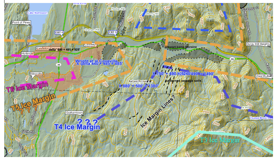
These occur between the T4 and T3 ice margins, which are correlated with the WMMS and its reported readvance. The VCGI sewage soil tab suggest more granular soils may be associated with these features.
In general, Ice Marginal Lines as mapped on VCGI are scattered broadly across Vermont, both singly and in clusters. Bedrock Grooves are prominent linear features, but these differ substantially from features mapped as Ice Marginal Lines, in that Bedrock Grooves are much more pronounced, clearly erosional features in bedrock terrain, with clearer evidence of formation by meltwater erosion along ice margins, commonly leading via Drainage Lines to downgradient kame deltas.
It is noted that the linears near Vergennes were examined in the Addendum study, showing that these likely are Mega-Scale lineations.