The following map shows the Orwell-Brandon area:
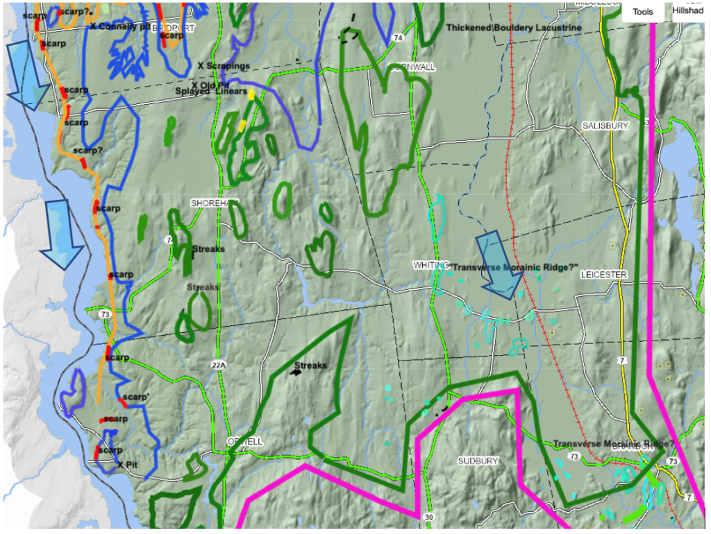
As can be seen this map extends from the previously described Bridport area southward to the Orwell-Brandon vicinities. This area is in the southern portion of the Champlain Basin.
Again:
- the maroon colored T6 margin and dark green colored early T7 margin are shown wrapping around the nose of the Taconic foothills in the Sudbury area. The late T7 margin is marked by the blue lines.
- The marine limit of the Champlain Sea is marked by the orange colored line.
- As noted above, the late T6 margin was associated with Coveville Lake Vermont and the early T7 margin with Lake Fort Ann.
- The lowering from the Coveville to the Fort Ann level triggered calving, with the T7 margin in many places associated with Ribbed Lacustrine, Headless Delta, and Thickened bouldery silt-clay deposits.
- The blue arrows indicate two ice streams, one in the Trough area of the main Champlain Basin, and the other in the Otter Creek Basin, projecting into the Vermont Valley.
- Scarps, delineated by red dashed lines, mark the lateral shear margin of the Champlain ice stream, between the marine limit and the late T7 margin.
Whereas diverse features were identified in this southern Orwell-Brandon area, similar to those described above, of prime importance was the identification of Scarps as identified on VCGI LiDAR imagery and shown on the above map. In general, the field examination confirmed the presence of these features. However, less effort was made, as compared to further north, to study these individually and to document the presence of buried sand and gravel beneath lacustrine silt-clay in the benches associated with Scarps. The Scarps, which are interpreted as marking the lateral shear zone of the Champlain lobe ice stream in late T7 time again in close association with but slightly above and therefore later than the Champlain Sea strandline, suggest a long narrow ice stream occupied the Trough of the basin in late T7 time.
The following is a close up from the VCGI map of this area in the area west of Orwell:
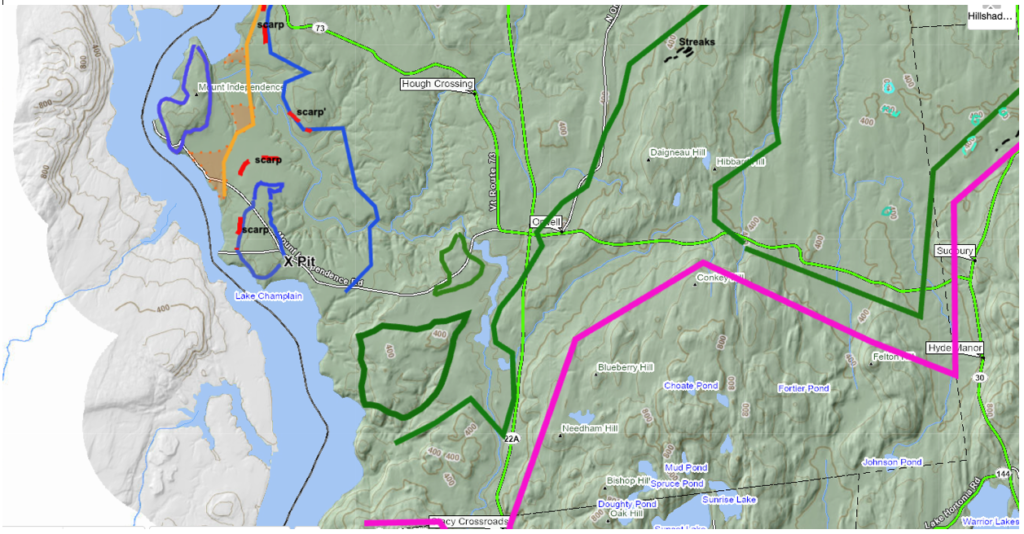
This area is significant because it is near the southern tip of the Champlain Basin trough lobe in T7 time, and more specifically the southern frontal tip of the Trough ice stream. Of particular interest is a gravel pit identified on LiDAR imagery. Stewart and MacClintock show the pit itself as “outwash” but the surrounding terrain as entirely “silt, silty clay, and clay.” The delineation of a mass of “outwash,” indicates the presence of gravel, but the ponded sediment in the surrounding terrain suggests that this is overlain by silt-clay soils. In as much as this is associated with the late T7 margin, this fits with and was suspected to be a Ribbed Lacustrine deposit. To the north of the pit is low flat terrain near the marine limit; SCS soil sewage favorability map tab on VCGI indicate that surface soils in this area are well drained Elmwood fine sandy loam soils. The elevation of the terrain at this deposit is 120 feet (37 m) which is close to the elevation of the Champlain Sea limit as marked by Chapman. Thus , this is interpreted and mapped as a deltaic deposit, as demarcated by the ochre colored shading, at the southern apex of the Champlain Sea.
The following is a closeup view of a LiDAR image from the pit area:
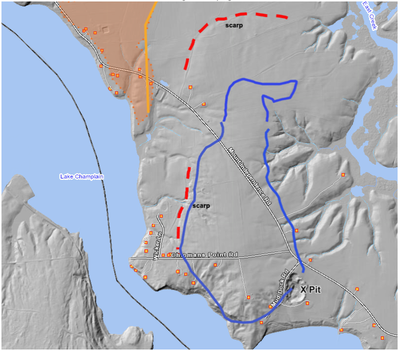
As can be seen the terrain in the vicinity of the pit and the Scarp is kamic, consistent with Ribbed Lacustrine deposits typically associated with Scarps. As noted above these features are interpreted as marking the position of an ice stream lateral margin.
The 2026 field mapping confirmed the presence of the Scarps and suggested kamic topography. Unfortunately, the pit identified on LiDAR imagery is now completely slumped and heavily vegetated. However, an elderly, retired farmer on neighboring property (Gerry Audet – name given by permission), who lived in the area his entire life, and was familiar with the pit, confirmed that it was a gravel pit, which he recalls likely began operations long ago, in the early 1900s , operated for 30-40 years, ceased to operate in the 1950s, that a clay layer approximately 5-6 feet (1.5 -1.8 m) thick overlaid the gravel, and that the debris piles from the clay layer which had been scraped off the gravel, became too large and expensive to move, which brought about the closure of the operation. He also confirmed that the flat terrain here identified as deltaic, part of his family farm, consist of sandy soils.
In essence, the above evidence supports the interpretation that the Champlain lobe in T6 time stood at the position marked by the maroon line on the above map, followed by recession of the ice margin to the early T7 position, as marked by the dark green line. Based on information further north, calving of the ice margin began at this time, with rapid recession of the late T7 calving margin position, marked by the blue line, with the Scarps marking the lateral shear margin of the calving ice stream, and with the kamic fringe representing the slower moving ice, consistent with the Batchelor and Dowdeswell Report.
Finally, it is noted that the 2026 field survey identified evidence supporting the eastern bifurcated early T7 lobe extending southward in the Otter Creek basin, as depicted on the above map. For example, the vicinity of the above reported features at Delong Hill is an area with substantial kamic topography and multiple gravel pits, all unfortunately closed , slumped , and overgrown. And the suspected Fort Ann delta with slightly kamic topography at West Salisbury is likewise confirmed,. However, the multiple topographic nobs in the northernmost, possible Transvese Morainic Ridge west of Brandon, were found to be associated with bedrock and are not glacial in origin.