In my previous mapping I identified linears and curvilinears on VCGI LiDAR imagery, which I identified as “Ice Marginal Lines.” These tend to be long, curvilinear, often but not always groove-like depressions, in the landscape. Such features often, but not always, are associated with soil differences as sometimes shown by Stewart and MacClintock’s State surficial geology map, but more commonly by soil differences as shown by the Soil Conservation Service soil maps, with more granular soils commonly associated with the Ice Marginal Lines. These Lines often occur as multiple, more or less parallel clusters or groups on the landscape, suggestive of the progressive recession of the ice margin. For example, Ice Marginal Lines on the northwest flank of the Taconic range is marked by quite pronounced curvilinear features which were identified in my previous VCGI mapping as Ice Marginal Lines associated with the T4-T6 step-down sequence of ice margins.
Also as discussed in my previous report above, some curvilinear features on the floor of the Champlain Basin were mapped as Ice Marginal Lines but were suspected as possibly being “Mega-Scale Lineations.” However, the available information then was insufficient to firmly establish their specific origin. These were re-examined both on LiDAR and as well by field examination as discussed below.
In this present, more detailed examination of LiDAR imagery I again identified, many elongate, linear and curvilinear features. These generally appear as feint tonal differences on LiDAR imagery, both with and without topographic, drainage, soil, or geological differences. Whereas some of these features clearly are associated and coincident with ice margins mapped previously on VCGI, most such linears are of unknown origin. I refer to these as “Streaks,” which I identified on the 2026 Addendum VCGI LiDAR maps by yellow colored dashed lines.
The following are examples of Streaks identified and mapped on VCGI:
- North and west margin of Snake Mountain:
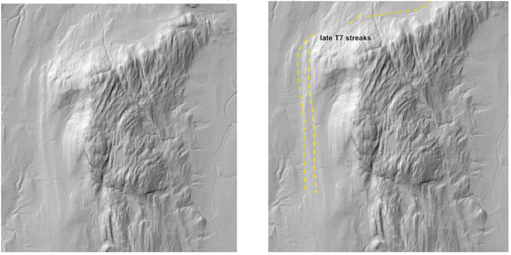
The image on the left is unmarked, making it easier to see the Streaks, which are marked on the image on the right. It is parenthetically noted that the crest and eastern flank of Snake Mountain is likewise marked by linear features. These are believed as well to be related to earlier, older ice margins, with bedrock structural fabric enhanced by drainage, perhaps as part of the distended “Ice Tongue Grooves” at the mouth of Otter Creek. But as noted, such an interpretation requires further study which was not pursued in this post January 2026 study.
2. On the basin floor in the Ferrisburg vicinity as shown on the following:
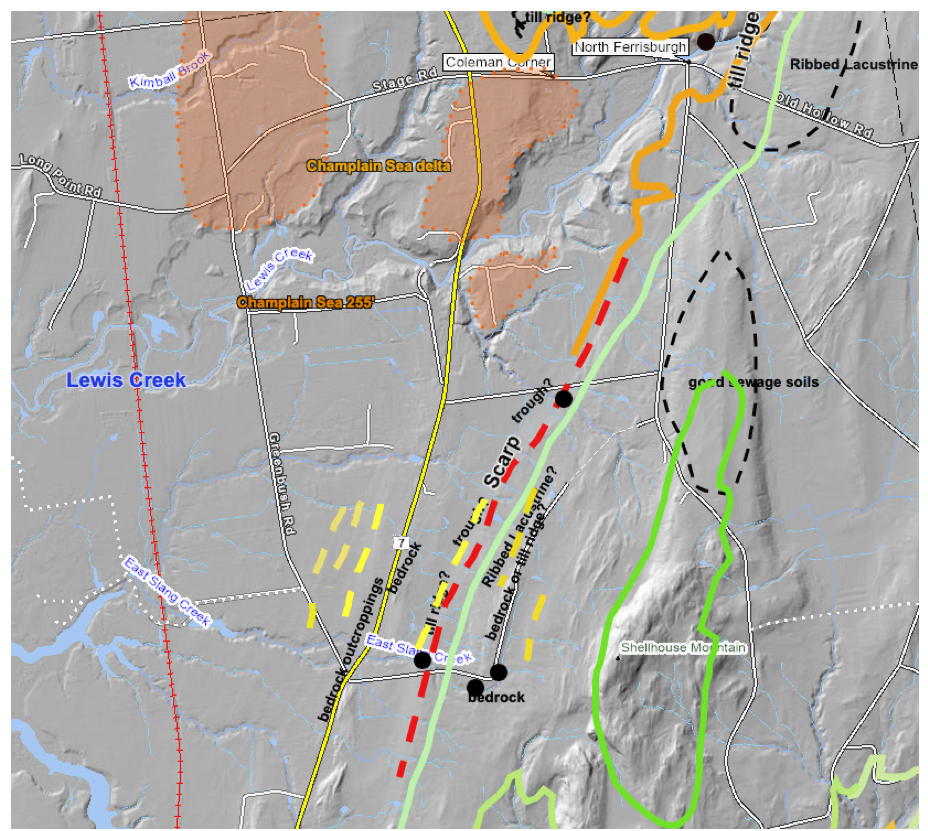
The yellow dashed lines represent very feint lineations on LiDAR imagery. A closer scrutiny suggests possibly additional linears on the Basin floor. They are difficult to identify and deal with because having made marks on LiDAR imagery such Streaks become difficult to see visually, with such markings then becoming distracting. The geological-historical meaning of these features remains unknown.
3. Very substantial, pronounced Streaks are found on the Basin floor in the area southwest of Vergennes, depicted by the dotted black lines, on the following map:
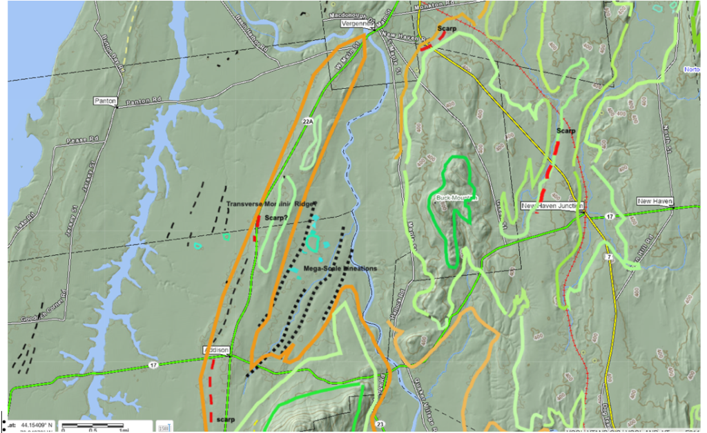
In the previous report these were identified as possible Mega-Scale Linears. These linears were studied by the recent field visits and are discussed below. Other linears are also identified on the basin floor as marked by thin black dashed lines the above map, but were not studied.
4. West Cornwall “moraines” (?)
The following LiDAR image is from the West Cornwall area.
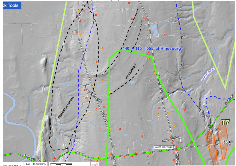
These linears appear as slightly curved ridges, which are in close proximity to and fit with the recession of the early to late T7 margin (the dark Greek and light green lines on the above map). These were suspected as possibly being moraines, deserving of further study. However, suffice it to say that field examination of this area showed these features are on the relatively flat top of a larger ridge-like hill, with evidence of a bouldery till ground moraine, but the ridges per se could not be seen or found.
This illustrates a problem with LiDAR. The ability of LiDAR imagery to detect many linear to curvilinear or other suspicious and possibly important features on the landscape is the “Good News.” The “Bad News” is that despite concerted effort in the field in many cases it was not possible to find any evidence which might shed light on the presence, nature, and origin of such features. Simply put, in most cases, again despite considerable care to locate such linears in the field, no evidence of the presence of these features could be found, let alone evidence pertaining to possible geologic or other mechanisms for the formation of the linears. Hopefully, future generations of researchers will be more successful in dealing with such features, which for now are mostly relegated to the mysterious “Unknown.”