The following is a VCGI map of this area:
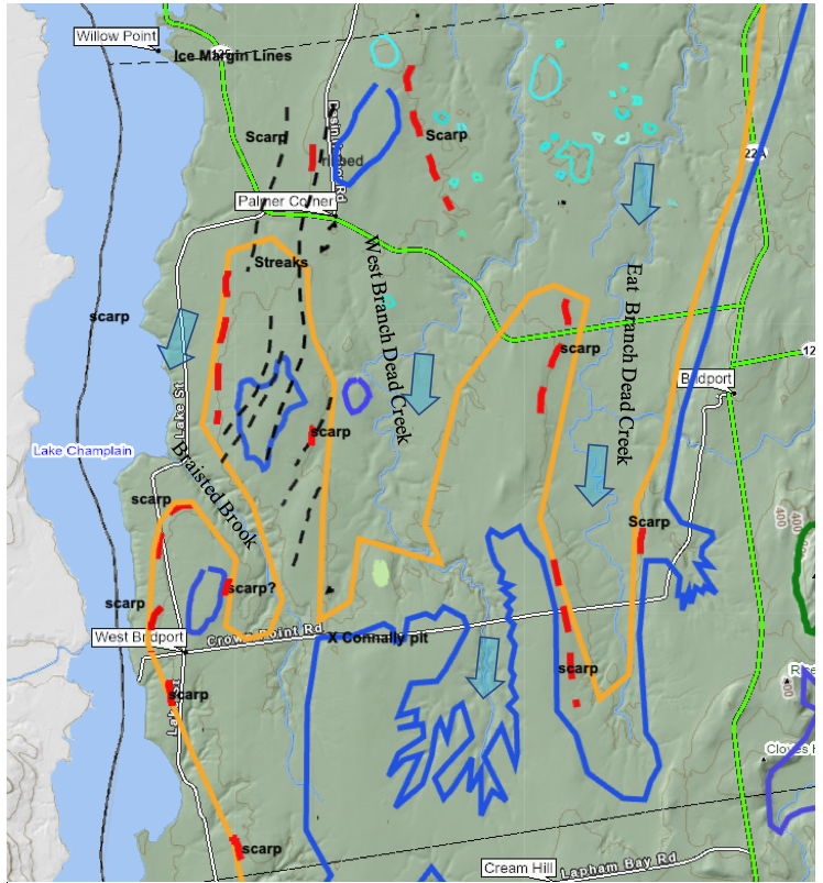
As can be seen, this area is immediately south of the features identified in the preceding as a Transverse morainic ridge for the main, western Trough ice stream. The late T7 margin is demarcated, in this area by the blue line, the marine limit by the orange line, and Scarps by red dashed lines. The blue arrows schematically suggest ice movement in the main Trough ice stream and its substreams in the East and West Dead Creek basins in late T7 time.
This area is especially important in as much as Connally reported a gravel pit exposure near West Bridport, with structurally deformed, interbedded till, gravel, and ponded water silt-clay strata, which he interpreted as indicating a readvance, his so-called “Bridport Readvance.” This readvance has been subsequently referred to in various reports and thus has become part of the literature for regional deglacial history. However, DeSimone and LeFleur, who subsequently attempted to verify this feature, were unsuccessful, leading them to call into question the validity of this readvance. In fact, Connally states that in his opinion, this was a minor readvance. Regardless, of the truth of the matter in regard to a “readvance,” photographs of this deposit given in Connally’s report clearly show deformation of till and associated other sediment, making it clear that, so to speak: “something was going on in the West Bridport area.” Based on an inferred location of the pit near West Bridport, and the close proximity of a prong of bouldery marine silts and clays nearby, in my previous report this readvance was previously correlated with the same T8 margin as the readvance identified by Wright in Charlotte and the aforementioned readvance in the Missisquoi Basin. Thus, the “Bridport readvance” added to the evidence for a long lobe in T8 time.
Unfortunately, Connally did not identify the exact pit location. He indicates the pit is located about 8 km west of Bridport, which is close to the present day Lake Champlain shoreline, near West Bridport. In a later report, Connally and Cadwell remarked that the pit was closed, slumped , and overgrown by vegetation. Efforts to find the pit, from the Town Clerk’s office and old timers still living in the area were unsuccessful.
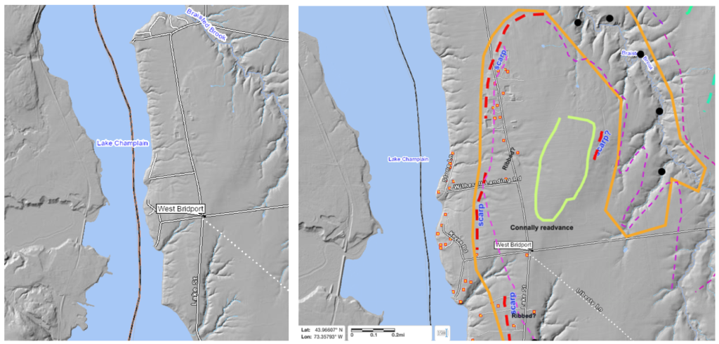
This area was examined on LiDAR, with the identification of what is believed to have been the pit exposure reported by Connally, as identified on the above map. This was field examined. It is a very small pit, now totally overgrown, but clearly in gravel. Topography at the pit suggests a local kame.
The following are screen shots of Connally photographs of his “Bridport readvance “ gravel pit:
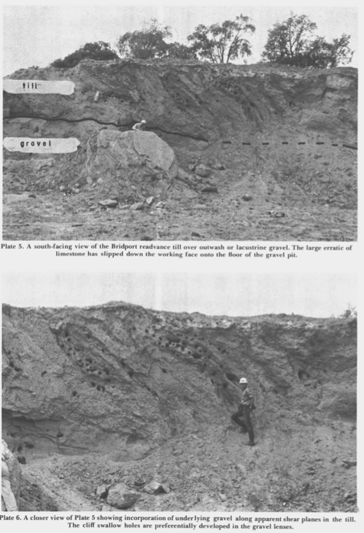
Connally indicates the photos are looking south, meaning east and west are to the left and right, respectively. His captions indicate that the exposure shows till overlying “outwash or lacustrine gravel” with “incorporation of underlying gravel along apparent shear planes in the till.(emphasis added)” Whereas the three dimensional orientation of the shear planes can not be specifically determined from the two dimensions given by the photograph, it is obvious that in general shear was west to east. As can be seen by the above map, the location of the pit is along the late T7 margin, near the headwaters of the West Branch Dead Creek. Multiple Scarps in the area suggest the main Trough ice stream was nearby to the west, with sublobes into Braisted Brook and West Branch Dead Creek Basins, again in late T7 time. Connally’s gravel pit is at the headwaters of these basins where multiple sublobe ice streams converged. Thus, it is likely that Connally’s “readvance” is actually instead a lateral shear margin of these ice streams.
Connally also shows striations in his map area, indicating southward ice flow. It is believed that these features were produced along a lateral shear margin associated with calving in late T7 time, and are not indicative of a readvance. This interpretation removes one of the major arguments for a long convex lobe at T8 time.
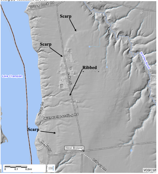
As shown on the above map multiple Scarps are identified in this area. The Scarps in this area were all examined, again showing typical topographic forms as described above. Whereas soils are everywhere dominantly silt-clay, no deeper subsurface soil information in the vicinities of the Scarp benches was found. The Scarps are obvious on LiDAR as shown on the following examples:
The following screen shot is a closer, enlarged view of the view of several of the Scarp(s) identified above:
The following is a close up screen shot from the VCGI Map in the Cream Hill area:
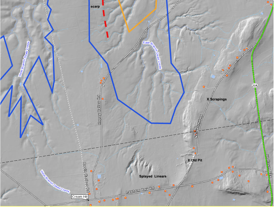
The “Splayed Linears” are distinctive features on a prominent bench, reminiscent of similar Splayed linears elsewhere along the late T7 ice margin, as for example just east of Vergennes as discussed above. Again, the exact mechanism of formation of these features is uncertain, but these and the associated bench are believed to have formed along the late T7 ice margin lobe near its frontal tip in Dead Creek basin. Nearby is an old gravel pit. This pit is no longer active and is badly slumped with no exposure of the strata or structures. However, the material in the pit floor and walls includes mostly silt and fine sand but separate masses of sand and in places gravelly material with highly rounded pebbles are found, which are typically associated with gravel. Soils on the land surface on the terrain around the pit are silt and clay. This deposit is taken to be part of a Ribbed Lacustrine deposit, formed along and by the late T7 ice margin. Nearby to the north is an area of shallow bulldozer “scrapings,” where similar materials scattered on the land surface are evident. The nob along the west side of N. Cream Hill Road is a bedrock nob.
A reconnaissance of this and the neighboring Middlebury Bench area to the east toward Cornwall and Middlebury and to the south toward Shoreham showed rolling low upland terrain with numerous bedrock outcrops. This is typical of the Middlebury Bench which is predominantly shallow bedrock controlled terrain with thin overburden. This overburden is mostly till, but in places near the VCGI margins includes Ribbed Lacustrine deposits. Evidence of stagnant ice presence along the ice margin is generally absent, although slightly kamic topography is suggested locally in some places.