The following is a large screen shot of this area to give an overview perspective, followed by a screen shot giving a closer view:
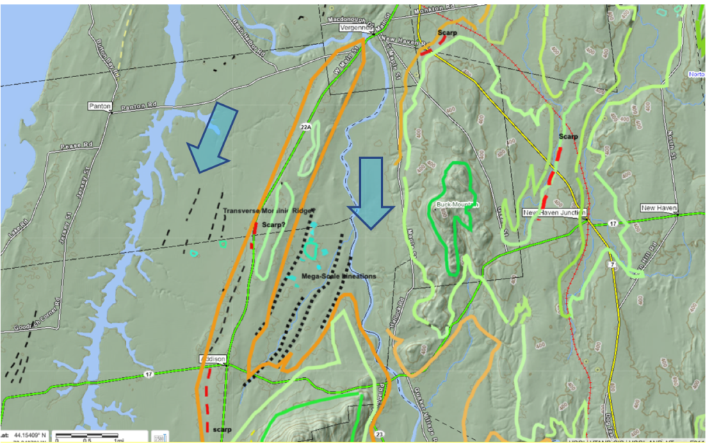
The village of Vergennes is located on the northern sector and of Addison to the south. The heavy colored lines designate the early T7 margin (dark green), late T7 (pale green), and Champlain Sea marine limit (orange). Drainage features include present day Lake Champlain on the west, Otter Creek, and Dead Creek. As can be seen Route 22A from Vergennes to Addison traverses a substantial topographic ridge. Bedrock outcroppings at various locations on the ridge indicate it is bedrock controlled. Buck Mountain marks the north side of the lower Otter Creek Basin, and Snake Mountain to the south. Otter Creek again is one of the re-entrant basins in the Middlebury Bench. In late T7 time, the ice sheet occupied the low areas including a sublobe in the main Champlain Basin Trough, and a sublobe in Otter Creek basin . The ridge along Route 22A was a low nunatak for the main Basin lobe.
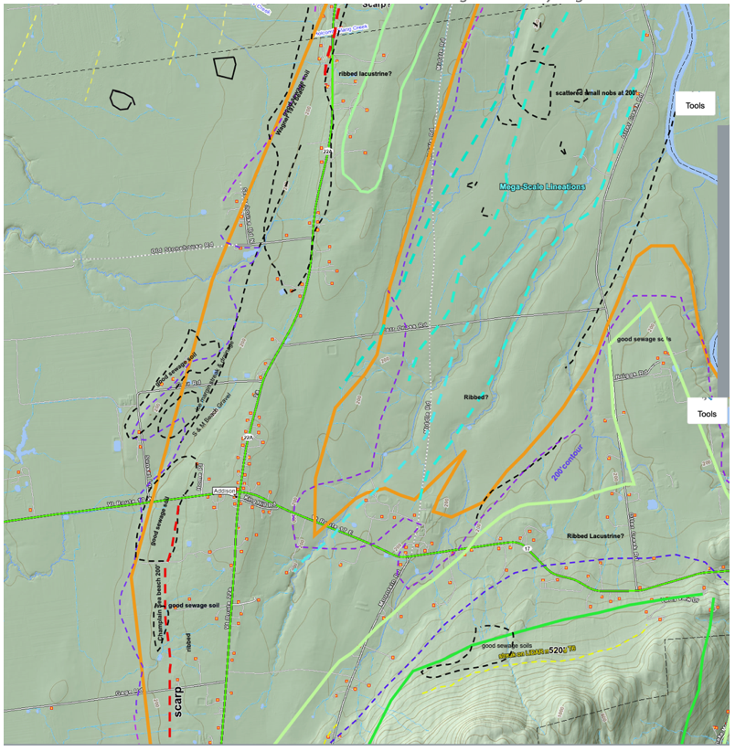
The above maps depict linears (black dotted lines in the first map and neon turquois colored dashed lines in the second map) ) which are interpreted as Mega-Scale Lineations. The length of the tract is about 3 miles (4.8 km). Topographically, the linears occupy the basin floor, with the floor of the terrain relatively flat, as shown on the following conceptual sketch:
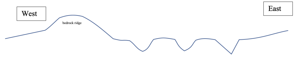
Based on topographic contours, the elevation difference between the floors of the linears to the height of the intervening terrain is about 20 feet (6 m). This profile is intentionally drawn schematically in a simplified way to convey the concept that the linears give the appearance of being incised into the terrain, with the tops of intervening ridges representing the basin floor. Exposures everywhere in the vicinity of the linears are shallow and indicate silt-clay soils which are not stony. If these grooves were formed by ice streaming at the ice sheet bed, as believed, this bed was subsequently veneered by lacustrine and marine silt-clay sediment.
The following is a photograph looking in a northwesterly direction across the basin floor, taken from a location near the northern end of the tract:
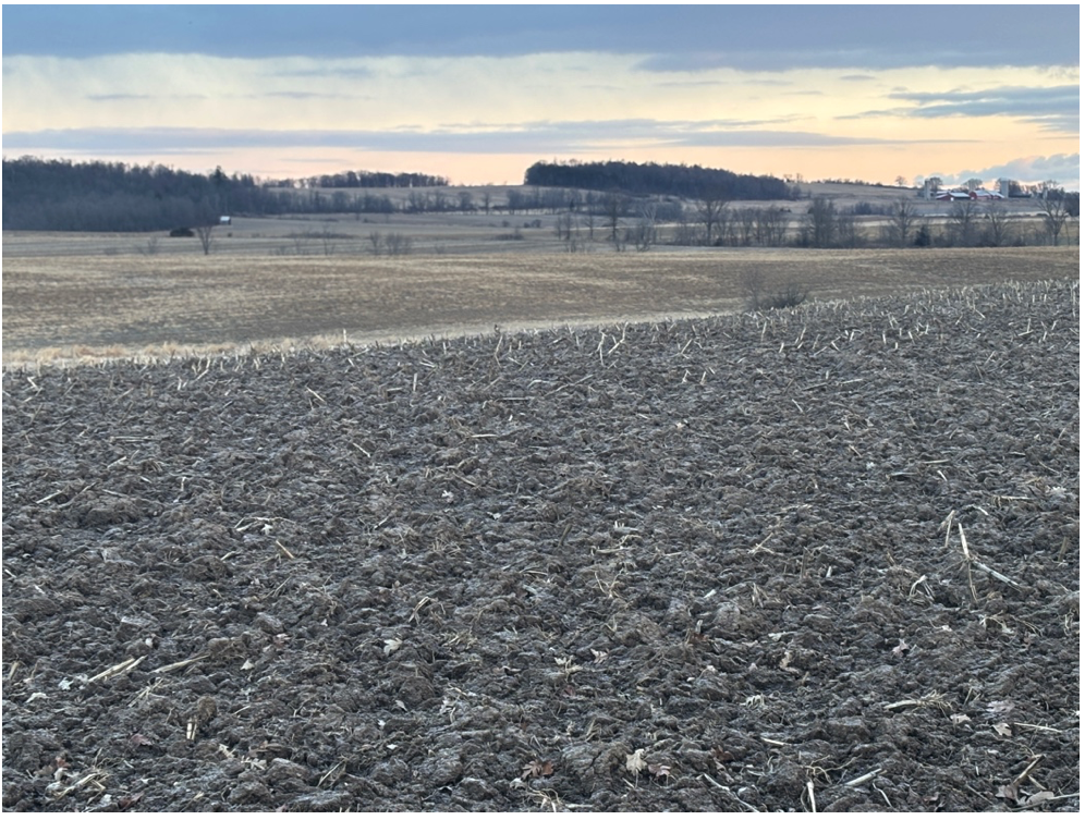
The wooded ridge in the distance is the bedrock ridge along route 22A. This photo shows the basin floor into which the MSLs (?) are incised. The linear elements cutting across the photo and tree-tops give a sense of the presence of these groove-like depressions, two of which are evident in this photo.
The linears were originally identified as “ Ice Margin Lines.” As my thinking evolved, owing to the fact that these particular linears represented topographic grooves on the landscape on the bed of an ice stream as indicated by Scarps, these features came to be regarded as more likely being “Mega Scale Lineations,” as described in the literature. In contrast, linear markings on LiDAR elsewhere on the floor of the Champlain Basin, associated only with tonal differences but no topographic expression, were identified as Streaks. These features are all intriguing, likely variations on a spectrum, and possibly related to ice recession, but as well in areas of shallow bedrock and thus alternatively as possibly bedrock structural features, or some combination thereof. Regardless of the terminology, this particular area is of interest for both Scarps and linears. Whereas the evidence does not absolutely establish that these particular features are Mega-Scale Linears, or some other related feature associated with ice streaming, taken together in the context of diverse other evidence, this interpretation fits with and is suggested by the data.
As also can be seen on the above maps is a series of Scarps, The northern Scarp near Vergennes was discussed in the preceding. Additional Scarps are located to the south in the Addison vicinity, per the following close up map:
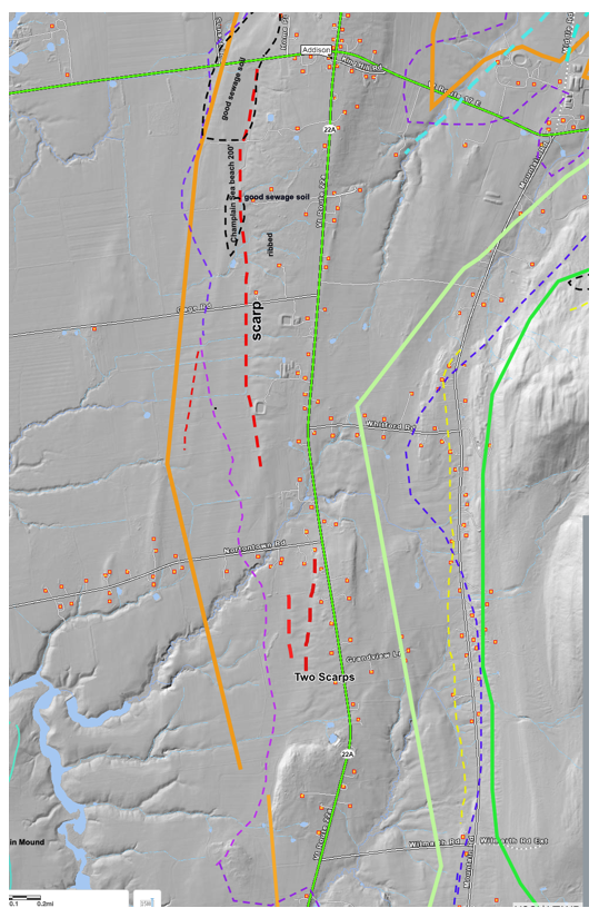
These Scarps were examined in the field. Whereas they are topographically recognizable, as benches with sloping Scarp faces, no information regarding subsurface soils was found. The southernmost Scarp is actually two Scarps, which may relate to multiple lateral shear moraines. But the data at this point are insufficient to further explore this possibility.