The following is a regional map from VCGI of the Vergennes area, which includes a portion of the Little Otter Creek Basin as just discussed and as well the Otter Creek and Dead Creek Basins:
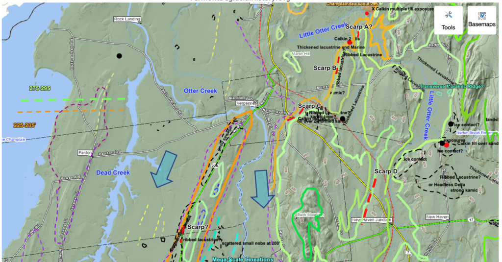
The Otter Creek Basin is a major basin in Vermont, as a re-entrant basin penetrating the Middlebury Bench. Unlike other re-entrant basins which extend into the foothills and Green Mountains in a west to east direction, the Otter Creek basin extends in a generally southeastward direction into the Vermont Valley. As previously indicated the Champlain lobe was bifurcated, with a sublobe in the Otter Creek basin into the Vermont Valley, separated from the main lobe on the Trough floor by the Taconic Mountain uplands. Both lobes were relatively robust. The blue colored arrows on the above map suggest these lobes. As a consequence of their orientation these lobes were more directly connected with the parent Champlain lobe to the north, in contrast to other re-entrant basins. This resulted in more vigorous ice streaming in the Otter Creek Basin as compared to other basins to the north, as marked by Scarps along ice stream shear margins.
It is noted that Streaks, as marked by yellow dashed lines on the above map, are identified on the Trough floor west of the mouth of Otter Creek Basin. However, field examination of these Streaks failed to show any helpful information. As discussed previously the meaning and significance regarding deglacial history of these features, if any, remains undetermined.
Also shown, by the bright neon turquois colored dashed lines on this map, is the northern portion of a tract of possible “Mega-Scale Lineation’s,” which are discussed in a subsequent section below.
The focus here is on a Scarp identified on LiDAR imagery just southwest of Vergennes along the west side of Route 22A, along a prominent ridge. Outcroppings indicate this ridge is bedrock controlled, but this topography affected the ice sheet margin and streaming as indicated by the Scarp. Many other Scarps have also been found and mapped further south along the same ice stream margin, as discussed below.
This Scarp is topographically evident, in places marked by a sharp and definite break in slope on the frontal edge of a bench. Residents in the area confirm the presence of silt-clay soils on the land surface. One homeowner reported that soils are “clayey” but sandier in the Scarp vicinity. Another homeowner, who happens to be a contractor, reported that in the construction of his driveway (which crosses the Scarp) sandy or gravelly soils were encountered. Whereas this driveway embankment is now overgrown with no good exposure of soil material, shallow shovel holes suggest predominantly silt-clay soils. However, scattered across this embankment are numerous rounded stones indicative of and consistent with the presence of gravel material. Whereas the Scarp is a definite and obvious frontal slope on the western margin of a distinct bench, kamic topography on the bench is not evident.
My mapping in the 1970s identified a long tract of Champlain Sea strandline beach deposits immediately west of Route 22A, at an elevation slightly lower than and below the Scarp base. Again, as noted above, this is a recurrent pattern, in many places with Scarp bases being close to but slightly higher than the Champlain Sea marine limit. In as much as Scarps are here interpreted as lateral shear margins of ice streams, whereas the proximity of Scarp bases to Champlain Sea features is helpful in the mapping process, it is clear that the Scarps formed prior to the Champlain Sea. Further, the association of Scarps with the late T7 margin, which is documented in many locations in this map area is important, further making it clear that the T8 margin which is identified with the readvance in the Missisquoi Basin did not extend southward in the basin, as for example to this Locale. This type of evidence, as discussed further below, indicates a long convex lobe in the Champlain Basin T7 time, with its rapid recession prior to the Champlain Sea and T8 time.