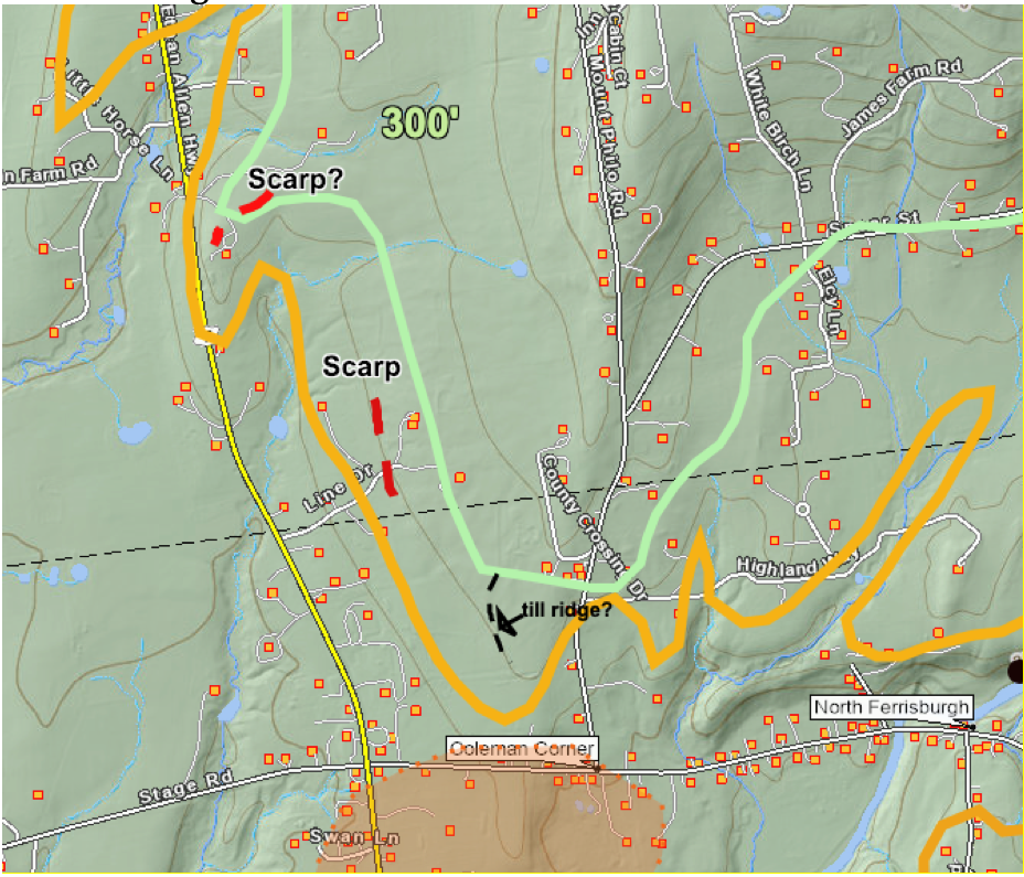
The following is a screen shot of the VCGI map of the Lewis Creek re-entrant basin:

Again, this is one of the re-entrant basins in the Middlebury Bench. The headwaters of this basin extend eastward to the Starksboro vicinity, close to the headwaters of the LaPlatte Basin. The maroon line represents the T6 margin. This line is only marked on some but not all of the higher hills. The dark green line represents the early T7 margin, and the light or pale green line the late T7 margin. The T4, T5, and T6 margins, most of which are further to the east of this map, are part of the step-down sequence associated with local water bodies along this margin. The T6 margin was associated with Coveville Lake Vermont. Coveville Lake Vermont lowered to the Fort Ann level, in close association with the early T7 margin, again as depicted on this map by the dark green ice margin line. As previously noted, in the neighboring LaPlatte Basin to the north, the evidence in Lewis Creek basin, including multiple Headless Delta, Ribbed Lacustrine, and Thickened Bouldery Lacustrine deposits, suggests westward recession of the ice margin by calving in T7 time, from early to late T7 time, as marked by the darker and lighter green ice margins, respectively. Whereas such documentation in Lewis Creek Basin as compared to the LaPlatte Basin is more limited, it is likely that a similar recessional history occurred.
The mouth of the Lewis Creek re-entrant basin is along the flank of the main Champlain Basin trough, with this margin marked by Pease Mountain and Mount Philo on the north side, and Shellhouse Mountain on the south side. Two Scarps and possibly a third are identified at the mouth of Lewis Creek re-entrant Basin along the flank of the Trough at the mouth of the Middlebury Bench, as marked by the red dashed lines on the above map. The blue arrows suggest ice streaming patterns, as deduced from all of the information as described and as well the Scarps. As noted above, the orientation of the upper Lewis Creek Basin and as well the upland terrain at the Basin mouth resulted in less vigorous streaming in the upper Lewis Basin. Scarps were found only at the mouth of this basin.
The yellow dashed lines mark Streaks, as described above. In this 2026 VCGI Addendum field examination, the Streaks as shown on the above map were not in any way identifiable in the field, with no evident physical topographic or geologic features. Thus, the meaning of these Streaks remains unknown. Soils in the area generally tend to be shallow lacustrine silt-clay, with numerous outcroppings. Foliation, bedding, and structural fabric in the bedrock is generally approximately north-south, and tends to give the terrain a linear grain.
Extensive bedrock outcroppings were identified along Robinson Road which extends along the pale green late T7 margin on the above map. These outcropping are limestone which are glacially smoothed but postglacial weathering has removed any evidence of striations as may have once existed. The structural trend of foliation and possibly bedding within the bedrock is basically north-south. However, in one location, possible glacial gouge grooves have been identified, cutting across this structure, possibly indicating ice flow in a S10 degree W direction. This direction would fit with the concept of late glacial ice streaming, as discussed further below. Thus, it is possible that the Streaks may reflect bedrock structure, but whether or not this was glacially enhanced in some way is possible but can not be established. Thus, the glacial meaning and significance of these particular Streaks, if any, remains uncertain.
On the north side of the Lewis Basin, near it Trough mouth, are two Scarps as shown on the following screen shot:
The northern of these Scarps was not examined in the field. The southernmost of these two Scarps, at the head of Lime Drive, was examined in the 2026 study. Whereas a local homeowner of one of the houses near to and just to the east of the scarp did not want to be specifically identified by name, they reported clayey surface soils with a new water well which reportedly encountered a surface layer of clay and an underlying gravel deposit, overlying bedrock (“ledge”). This fits with and supports the identification of a Ribbed Lacustrine deposit which corresponds with the late T7 margin. The terrain is very gently rolling, not obviously or strongly but possibly slightly kamic, as a bench which slopes gently to the west, and the Scarp itself corresponding with a steeper slope. No exposures at the Scarp were found, but surface soils appeared to be fine grained silts and clays, and not particularly stony.
A prominent Scarp is identified on VCGI LiDAR imagery on the south side of Lewis Creek along Robinson Road, per the following screen shot:
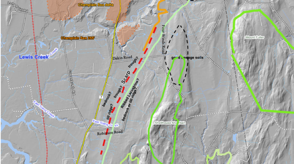
The dark green line represents the early T7 margin, the light green line the late T7 margin, and the orange line a portion of the approximate Champlain Sea strandline. The dashed red line is the Scarp which marks the frontal edge of a suspected Ribbed Lacustrine deposit along the late T7 margin. And the ochre shaded area represents the Lewis Creek Champlain Sea delta. Again, as can be seen, this Scarp is close to but slightly above the Champlain Sea strandline. The Lewis Creek Champlain Sea delta is mapped based on my 1972 mapping and as well on Soil Conservation Service soil sewage favorability maps and the Stewart and MacClintock State surficial geology map (which identifies the delta as a “pebbly marine sand”). Again, the Scarp elevation is slightly above the Champlain Sea level, and thus predated the Champlain Sea.
For comparison, the following screen shot shows the vicinity of the Scarp, without its being marked, in order to illustrate how subtle such features can be, though in many locations Scarps are more pronounced in LiDAR imagery:
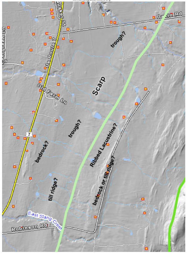
This Scarp is traced for a distance of about two miles (3.2 km), just west of Route 7, basically along the flank of the Champlain Basin Trough which is quite prominent and obvious, approximately between Dakin Road and Robinson Road. Terrain in the Scarp vicinity generally slopes gently downward in a westerly direction with a low slope. But again, the Scarp is on the western flank of the Trough, which is a substantial low Basin floor to the west. As can be seen, LiDAR imagery in places shows a furrowed Scarp base, which may represent incipient Lateral Shear Moraine development. Also, other furrows are evident, basically parallel to the contour at higher elevations. A Ribbed Lacustrine Bench is identified at the late T7 margin, extending up to the early T7 margin. Of course, the terrain may as well reflect the influence of bedrock which is shallow in the area.
The area of the Scarp was traversed along Dakin Road. Again the Scarp marks a steeper slope along the terrain, to the east of which is a slight bench, with no evidence of kamic presence. No good exposures were found in the area. One of the homeowners indicated soils were clayey A homeowner on the scarp itself reported that soils are clayey but that ledge is shallow. A drainage ditch along Dakin Road at this location showed a bedrock floor of the ditch. The area delineated as “good sewage soils,” which is taken from VCGI’s SCS tab, appears to be a bedrock nob with a thin till cover. No exposures were found along Four Winds Road.
The southern portion of the Scarp is traversed by Robinson Road. A stream exposure at the Scarp shows shallow silt-clay soils, with no stones, overlying bedrock. As noted in the Introduction section above, bedrock outcrops along the upper, north-south portion of Robinson Road are numerous. Glacial gouges indicate ice movement in a S10W direction which fits with the concept of streaming of the Champlain lobe.