One of the most important findings of the Addendum study has to do with the “collapse” of the Champlain lobe. I do not use the term “Collapse” glibly. I did not begin this study with this in in mind. Instead, as discussed further below this realization grew and evolved from multiple pieces of information from which the concept of “collapse” evolved and matured.
In general, the term or concept of collapse generally refers to instability, ice streaming, calving, and rapid recession of the ice margin. Most significantly and critically , ice lobe, ice sheet, or glacier collapse in its essence is a non-reversible, self-perpetuating condition leading to a substantial, usually rapid recession of the ice margin. In a worst case scenario a collapse can lead to the complete demise of a glacier or ice sheet lobe. A collapse can be caused by multiple, different triggers related to the Glacial Dynamic destabilization of an ice lobe or glacier, and is a Glacial Dynamic for a glacier, ice sheet, or a lobe to return back to a normal condition.
As just stated, my sense about a possible collapse of the Champlain lobe came about progressively, by the accumulation of multiple thoughts or factors:
- Perhaps most important is that, as has long been known, the recession of the Champlain lobe took place in a reverse gradient setting. Such settings are widely recognized as causing or being associated with calving and destabilization, in some cases irreversibly and self-perpetuating, leading to a collapse. However, whereas a reverse gradient setting is necessary for a collapse, not all such settings are associated with a collapse.
- Evidence for calving was another element of my evolving understanding, such as early on as reported by Stewart and MacClintock. Calkin, and others. However, again, whereas calving is associated with a collapse, calving margins may be relatively stable and do not necessarily indicate a collapse.
- Further, as stated above in my report, the evidence indicates that Coveville Lake Vermont first developed in the southern part of the Basin, and was localized to a narrow corridor between the terrain and the ice margin, that this corridor was associated with a “Disaggregated margin,” as described in the literature in conjunction with ice sheet destabilization with northward penetration of standing proglacial waters through a myriad of openings along the margin, along the eastern margin of the Champlain lobe. That this took place progressively and rapidly is documented, for example, by the development of major deltas as for example at Benson Landing, Castleton, Proctor near Rutland, Brandon, Pittsford, East Middlebury, Bristol , and South Hinesburg, as described in detail and at length in the above report. In time, I came to see this as a significant destabilizing factor for the Champlain lobe, essentially a decoupling of the ice lobe from its lateral and frontal tip margins. Whereas such decoupling may in a sense have diminished the “gripping” of the ice sheet to the terrain, the low tensile strength of ice limits such gripping. On the other hand, such decoupling had the effect of decreasing buttressing support, which is widely recognized as a significant Glacial Dynamic associated with calving and instability. This instability is further suggested to possibly be marked by “Ice Tongue Grooves” at the mouths of the major basins, specifically the Otter, Winooski, Lamoille, and Missisquoi basins, although the validity, meaning, and significance of these features requires further study.
- Still another, major factor, in my thinking was my recognition that the Champlain lobe recession was associated with progressively larger, more regional water bodies. This regional coalescence was important because sudden changes in water levels for these larger water bodies, particularly when and where these changes were sudden and substantial, can alter the buttressing support and possibly other hydrodynamics in and below the ice sheet, resulting in instability. Further along this thinking, at an early time I recognized evidence which indicates that the lowering of Lake Vermont from the Coveville to the Fort Ann level, which as stated was substantial and sudden, led to calving and rapid recession. This evidence dates back to my mapping in the 1960s and 1970s when I identified substantial stagnant ice deposits which are veneered by overlying silt-clay strata. Such deposits were mapped at multiple locations in the Champlain Basin but back then I did not understand their significance. This recent revisit and reexamination of such features, thanks to LiDAR, led to the recognition that such features as Ribbed Lacustrine deposits, Headless Deltas, and Thickened Lacustrine Deposits, all of which represent the sudden opening of the lateral open water corridor when Lake Vermont lowered from the Coveville to the Fort Ann level.Further, my subsequent mapping of such features in the re-entrant basins within the Middlebury Bench clearly documented the progressive recession of calving ice margins of individual ice streams in a generally westward, downgradient direction within each of these basins in T7 and Fort Ann time.
- Another factor, or causative agent for triggering instability, may be hydrofracturing, with full pentration of the ice sheet by crevasses, as described in recent glaciology literature. In my above report I hypothesize that perhaps the thickness of the Champlain lobe relative to elevation of the floor of the Champlain Basin, particularly in the raised portion of the floor at the Middlebury Bench, may have reached a critical point where “hydrofractures” as described in the literature, may have developed so as to penetrate the entire thickness of that portion of the Champlain lobe so as to alter the lobe Glacial Dynamics. Such hydrofracturing might, in theory, result in mass stagnation as part of the ice lobe destabilization. However, whereas the levels of the ice sheet over the Middlebury Bench as determined by my mapping, reached the point that ice sheet thicknesses were in the range of full crevasse penetration, this remains as a theory, not an established fact.
- Important evidence for a collapse came from my Spring 2026 re- examination of the Champlain Basin floor LiDAR imagery as part of my re-examination of the long lobe issue. This led to the recognition of Scarps, Transverse Moraininc Ridges, and Mega-Scale lineations. All of these are calving margin type features, but Scarps were of particular interest because a) they fit with and are believed to have been associated with Lateral Shear zones of the Champlain Lobe ice stream which developed along the edge of slower moving or stagnant ice in the lower Trough portion of the Basin floor physiography, and b) they are numerous and provide remarkable definition to the ice stream and its split-fingered portions in the headwaters of the Basin floor.Scarps are indicative of, as the above indicates, shearing, Transverse Morainic Ridges indicate a halt in the recession of a calving margin, and Mega-Scale Lineations relate to lubrication at the base of the ice sheet. Interestingly, Calkin in the Middlebury area Van Hoessen in the Monkton area, and Wright in the Charlotte area, all within close proximity in the Middlebury Bench, refer to evidence of basal gravels which is regarded as meltwater associated with the base of the ice sheet. Wright also refers to a “Deformation Till.” His photographs and description of this till, and as well a similar till I observed at his Readvance locality, suggest a dense lodgement type till with foliation, and an unusual number of rounded pebbles oriented more or lee parallel with foliation. This is an unusual till which I suspect formed by shearing of gravels at the base of the ice sheet into till, as described in the literature, for Lateral Shear Moraines. I came to recognize that the progressive thinning of the Champlain lobe and the calving recession of the reentrant basins within the Middlebury Bench took place in times which by my terminology correspond with Early to Late T7 time, and that by Late T7 time the Champlain Lobe became decoupled from the Middlebury Bench, representing a major loss in buttressing support for the Lobe, such that ice streaming and calving recession of the lobe accelerated substantially at that time, whereby the Champlain Lobe receded northward with a brief halt for the formation of a Transverse Morainic Ridge in the Addison area in Very Late T7 time, followed by continued northward recession by which the Champlain lobe receded from Vermont in what is referred to here as “Very Very Late T7 time.”
- Finally, the age dates available for this recession likewise suggest a very speedy recession, consistent with a collapse. This recession of the Champlain lobe as just described is dated by the correlation of the T3/T4 margin with the White Mountain Morainic System and by a published date for the incursion of the Champlain Sea, which indicates that this recession occurred in less (probably much less) than about 800 – 1000 years. This rate of recession compares to modern day ice sheet margin calving recession rates, and possibly collapse recession rates.
The above evidence and thinking has thus led me to regard the recession of the Champlain lobe as a “collapse.” One of the most important pieces of evidence came from the January 2026 Addendum discovery of Scarps, Transverse Morainic Ridges and Mega-Scale Lineations. These features bear significantly on the issue of the collapse of the Champlain lobe, bear further discussion here.
The examination of LiDAR imagery as part of the January 2026 Addendum study utilized the services of VCGI, which is helpful not just for the service of providing LiDAR imagery for Vermont, but as well integrated information from other sources, such as published geologic reports, Soil Conservation Service soil information ,soil aggregate maps from the Vermont Highway Department, and other helpful and relevant information. However, as noted in my January 2026 report these maps do not easily lend themselves to graphic presentation of findings.
For example, the following VCGI map was developed in my January 26, 2026 Addendum study. This map, which again was developed from VCGI mapping, shows the T6 ice margin (maroon). The late T6 ice margin was closely associated with Coveville Lake Vermont, which extended northward along the eastern Disaggregated margin of the Champlain lobe, as a long narrow, more or less open water corridor. In a sense, this contributed to the collapse of the Champlain lobe which took place in T7 time, by this open water corridor serving to diminish the physical linkage between the Champlain lobe and the terrain.
The green colored lines on the following map designate Early T7 time, when the Coveville level lowered to the Fort Ann level, as marked by diverse features as described elsewhere, such as Ribbed Lacustrine deposits, Headless Deltas, and Thickened Bouldery Lacustrine deposits. This lowering was a major contributing factor causing calving and eventually collapse of the Champlain lobe. During T7 time, ice streams developed in the multiple re-entrant basins in the Middlebury Bench, with progressive westward, downgradient recession of the calving lobe tips in these basins.
In late T7 time (blue color) these calving lobe tips stood at the western margin of the Middlebury Bench, and immediately on the eastern margin of the lower elevation portion of the Basin floor referred to here as the “Trough.” The transition from the Bench to the Trough floor is a pronounced, substantial lowering of the terrain, downward to the lower floor of the Basin.
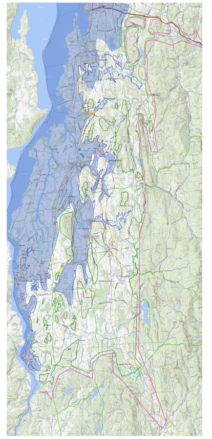
The Addendum, dated April 2026, identified Scarps, Transverse Morainic Ridges , and Mega-Scale Lineatiions, all of which are part of the evidence interpreted as indicating a collapse of the Champlain lobe beginning in Late T7 time and continuing through Very Late T7 time, and finally Very Very Late T7 time, when the Champlain lobe exited Vermont. Whereas the above map is difficult to read, the blue colored shading is added to give a sense of the Champlain lobe footprint at this time. This delineation is largely based on numerous Scarps, totaling 44 such features. These features represent a Signature which facilitates the mapping of the Late T7 margin. Whereas individual Scarps are marked by red colored lines, scale limitations make it very difficult to see individual Scarps.
It is important to note that whereas the ice masses in the re-entrant basins in Early to Late T7 time were calving ice streams, much of the Champlain lobe in the Middlebury Bench between these re-entrant basins was grounded on the irregular terrain of the Middlebury Bench which served to provide buttressing support for the lobe. However, in late T7 time this buttressing support no loner existed, which is believed to have been a major contributing cause of the Champlain lobe collapse. As can be seen, the Champlain lobe at that time consisted of a main mass in the Trough, but to the south this mass was split fingered with splayed, split fingered smaller ice streams, as controlled by the micro-physiography of the Trough floor in the headwater area.
In order to more easily visualize the physiographic divisions which played an important role in the development of calving ice stream, the following map was developed. The base map for this regional perspective is a LiDAR based, shaded relief map, taken from the same online source as referenced above. This is basically a physi0graphic map, similar to the many such maps presented in my full report. The map area is only for the southern portion of the Basin, from the Burlington area southward to the Orwell area, essentially the area of the January Addendum study. Again, this particular map is helpful in that it gives a sense of the different physi0graphic portions of the floor of the basin. which relates to ice margin conditions associated with the Champlain lobe recession. It is emphasized that this map was drawn as an approximation of the ice margins as identified in my original study and the January 2026 Addendum. It is intended to be schematic and conceptual.
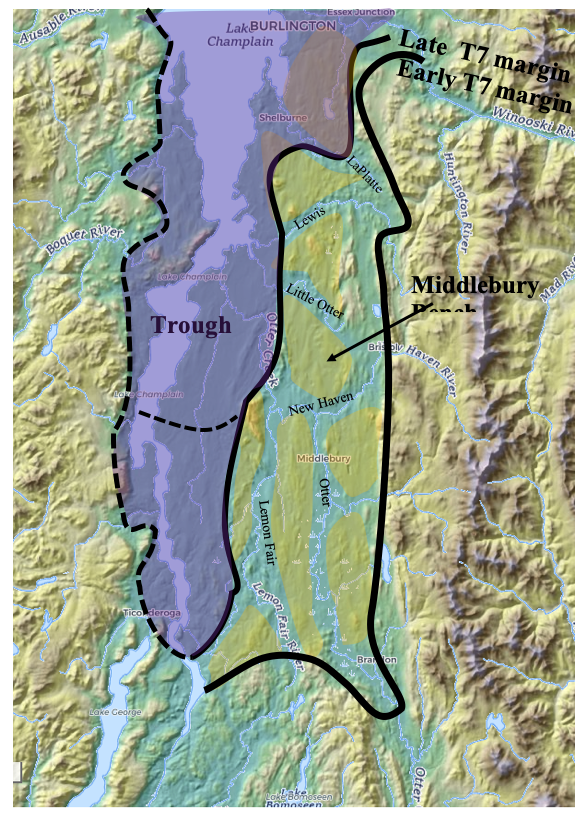
The orange color shaded areas demarcate portions of the Middlebury Bench. This Bench, again is a slightly elevated portion of the Champlain Basin floor, which lies west of the Green Mountain Foothills and east of the Trough which is a lower portion of the Floor. The Early T7 margin represents the base of the step-down sequence of ice margins from T3 to T6. Coveville Lake Vermont, which is not depicted on this map, occupied the aforementioned narrow more or less open water corridor that formed in Late T6 time, along the base of the step-down sequence.
The purple shaded area represents the main mass of the Champlain lobe in Late T7 time, when the rapid northward recession of the margin began as part of the collapse, as marked by Scarps in Vermont. The extension of this ice mass into New York is uncertain, but is shown as extending close to and along the Lake Fort Ann (Akawasasne) strandline. Whereas , as discussed above, the Champlain lobe became progressively destabilized with calving of multiple ice streams in the Middlebury Bench in Early T7 time, it is believed that the Lobe collapsed, beginning in Late T7 time, with a temporary halt near Addison (dashed black line) as marked by a Transvers Morainic Ridge in Very Late T7 time, but that by Very Very Late T7 time this lobe no longer had a presence in Vermont.
Whereas the above map only shows a portion of the Champlain Basin, basically from the Burlington area southward, as discussed in the first Addendum, Scarps, Headless Deltas, Ribbed Lacustrine Deposits, and Bouldery Lacustrine deposits have been identified further north in the Champlain Basin.
Of course, the focus here is on Vermont. As stated, whether or not evidence fitting with the interpretations given here for Vermont may exist on the New York side of the Basin is unknown. Fundamentally, as can be seen the terrain on the New York side of the Basin differs significantly from Vermont, in that a Middlebury Bench and Trough type terrain are absent in New York. In addition, of course, as previously noted, the “Deep Lake” near the New York/Vermont border may have further served to cause differences in the deglacial histories between the two regions.