As stated in the Introduction above, the purpose of this Addendum investigation is to re-examine the finding of a long, convex ice lobe in late glacial time, as discussed in my January 2026 report version. To recap, I previously found:
- In T3-T6 times the Champlain lobe extended southward in the Basin, with a bifurcated lobe, with an eastern sublobe in the Vermont Valley and a western sublobe in the main Trough portion of the Basin, separated by the Taconic uplands. The T3-T6 ice margins represented a step-down sequence, with successively lower ice margins fronted by progressively coalescing, larger and lower, local proglacial lakes. In late T6 time, these water bodies led to the Coveville stage of Lake Vermont, with Coveville waters penetrating along the eastern margin, and progressively extending northward in a narrow, more or less open “Disaggregated” type margin, eventually reaching the vicinity of the Winooski Basin.
- As previously indicated, the development of coalesced, regional water bodies was significant, because changes in the levels of these water bodies, especially if substantial and sudden, as was the case here, had a substantial impact on the ice sheet and its “Glacial Dynamic” and “Styles.” As noted elsewhere in my previous report, this is a clue with possible relevance to present day Antarctica and Greenland potential instability.
- Based on the likely substantial water depths of Coveville waters in the western “Deep Lake” portion of the Trough an initial phase of calving in T6 time was surmised, mostly in New York, with the calving margin of the western sublobe rapidly progressing northward. This calving and associated open water in the western part of the Basin was previously referred to as helping to explain part of the “schizophrenic” differences between the deglacial histories of Vermont and New York. Based on the current Addendum findings, this early calving is not possible because the later T7 ice margin still stood further to the south. Thus, this hypothesis is incorrect and is discarded.
- In early T7 time Lake Vermont lowered to the Fort Ann level,1 As discussed previously, this lowering was both sudden and substantial, resulting in calving in the re-entrant basins in the Middlebury Bench along the eastern margin of the Champlain lobe, and also on the south-facing frontal tips of the bifurcated Champlain lobe. Also as discussed previously, instability, recession, melting, and calving may have also been promoted at the same time by the breakout of Lake Iroquois in the Ontario Basin at the Covey Hill vicinity in northeastern New York and southern Quebec, and by the draining of Lake Mansfield. Whereas these events likely did not increase physical stress, the thermodynamic effects on the ice sheet may have been substantial. triggering calving marked by extensive Ribbed Lacustrine, Headless Delta, and Thickened Bouldery Lacustrine Deposits:
- Ribbed Lacustrine Deposits are characterized as benches along sloping bedrock controlled hillsides, composed of stagnant ice sand and gravel material, buried beneath a veneer layer of lacustrine silt and clay, with topographic ribbing suggesting melting of buried ice resulting in the ribbing.
- Headless Delta deposits formed from drainage of melting ice in the Ribbed Lacustrine deposits, with drainage lines graded to the Fort Ann level.
- Thickened Bouldery Lacustrine Deposits extending along basin floors, especially in the re-entrant basins, suggest the progressive recession of ice stream lobe tips, again in both re-entrant basins and the south-facing lobe tips basins.
- I previously thought that the ice margin in late T7 time in many re-entrant basins tended to be located close to the Champlain Sea marine limit deposits ,with evidence suggesting ice presence in Champlain Sea time. Further, the evidence, as reported previously, suggested that the lowering of Lake Vermont from the Fort Ann level to the Champlain Sea level triggered a third phase of calving, with evidence of the ice margin in close proximity to Champlain Sea waters, in T8 time. This evidence included:
- Cannon (1964) and Wagner (1972) both reported of evidence in the Missisquoi Basin, indicating a readvance, interpreted by me as being in T8 and Champlain Sea time.
- Wright(2010) reported evidence , as discussed above, which he interpreted as marking a significant readvance, specifically at an exposure in the lower LaPlatte, showing deformed lacustrine silt -clay and sand strata. In my previous January 2026 report I correlated these deposits with a nearby Champlain Sea delta in that basin. Stewart and MacClintock had mapped this delta as a kame terrace. As part of limited field work leading to my previous January 2026 report, I examined an exposure in this deposit, finding a silt-clay veneer over deltaic sediments with intermixed coarse sand and gravel suggestive of formation in close proximity to an ice margin. The silt-clay veneer was correlated with a similar veneer mapped and reported by Cannon (1964) and Wagner (1972) in Champlain Sea deltaic deposits in the Missisquoi Basin, which along with till bodies in these deposits led me to identify a T8 readvance. Thus, the deposits just described at the Champlain Sea level in the LaPlatte Basin were correlated with the Missisquoi Basin deposits, suggesting a readvance in T8 time of a long convex lobe to account for the features just described in the lower LaPlatte.
- Further, also as discussed above, in the West Bridport area, Connally reported evidence which he interpreted as a readvance. Whereas the exact location of this deposit was not reported by Connally, and at the time of my previous report was uncertain to me, it appeared to be in the West Bridport area. Based on the Stewart and MacClintock map showing a projection of bouldery marine silt and clay deposits extending southward on the Basin floor in the West Bridport area at the Champlain Sea level, it seemed reasonable to infer that Connally’s readvance as well represented a calving ice margin extending southward in the basin to the West Bridport area in Champlain Sea and T8 time.
Thus, the previous thinking, as presented in my January 2026 report, led to the suggestion of a long convex lobe in T8 and Champlain Sea time. As indicated above, David Franzi expressed skepticism about such a long convex lobe at such a late time, based on his mapping in New York, which suggested to him that the ice margin by Champlain Sea time stood north of the Quebec border , as had been previously suggested by Chapman’s classic report. Further, David examined theoretical ice sheet profiles, also suggesting to him that such a long convex lobe in T8 and Champlain Sea time was not sustainable. This discussion was helpful, inspiring me to take another look at this issue, leading to this Addendum report.
One of the first steps in this reconsideration of the T8 margin and its long convex lobe was the examination of ice margins on LiDAR imagery, and the mapping of a late T7 margin. This led to the identification of “Scarps,” which I now believe are numerous and important ice margin features related to calving of the Champlain lobe in late T7 time, prior to Champlain Sea and T8 time. This in turn led me to literature, specifically reports of lateral shear margins which fit my delineation of Scarps. Further, features identified in the literature as Transverse Morainic Ridges and Mega-scale Linears were also identified on LiDAR. This evidence likewise pointed to the presence of features associated with ice streaming and associated lateral shear zones.
The following two maps present information related to these features. The first map below shows the Scarps, Mega Scale Lineations, and Transverse Morainic Ridges identified on LiDAR, the early and late T7 margins, and the Champlain Sea strandline.
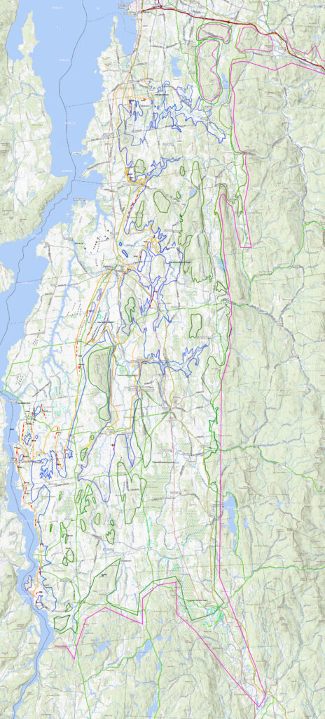
The second map, shown below, is essentially the same map as above but with the ice sheet coverage associated with the ice margins shaded to give a better sense of the ice margins and associated deglacial history:
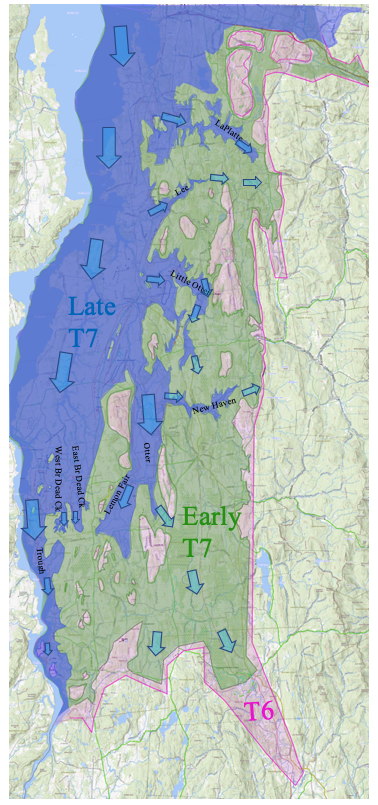
These maps show the margins and associated drift sheets for T6 (maroon lines and shading), early T7 (dark green lines and shading) , and late T7 (dark blue lines and shading) times, and as well the marine limit (orange lines), Scarps (red dashed lines), Ice Margin Lines and Streaks (black dashed lines), Mega Scale Linears (black dotted lines), and Transverse Morainic Ridges (neon green lines). The ice margins are basically similar to those presented previously, prior to this addendum, except that : a) the late T7 ice margin is added, with adjustments based on new information from the Addendum, and b) the previously delineated T8 margin is intentionally omitted. It is now believed that the T8 margin was restricted to the Missisquoi Basin.
The T6 margin, which represents the bottom of the T3 to T6 step-down sequence is only crudely drawn to give a general sense of the position of the T6 margin, which serves as a beginning time for the discussion below. Some but not all Nunataks for the different T times are drawn.
The early T7 ice margin shows the extent of ice cover at early T7 time, basically extending widely across the Middlebury Bench. The early T7 ice margin is at the beginning of Fort Ann time, which again was associated with lowering of regional water levels which likely suddenly and substantially removed buttressing support, triggering calving of individual ice streams in the Bench. These ice streams are identified by arrows on the above map, specifically in the LaPlatte, Lee, New Haven, Little, Otter, and Otter re-entrant basins. Interfluve areas between these basins generally are rolling uplands of the Middlebury Bench which are veneered by thin till ground moraine with upland knobs marked by bedrock outcroppings, and only scattered stagnant ice deposits.
As indicated above, the evidence indicates that ice margins were both hybrid types and diachronic. Whereas my previous VCGI mapping recognized and differentiated early and late T7 times, only the T7 margin representing early T7 time was marked on VCGI maps in my previous mapping. T7 time deposits were previously mapped and found to be numerous in the re-entrant basins in the Middlebury Bench. Multiple Thickened Bouldery Lacustrine Deposits on Basin floors suggest progressive recession of the calving lobe tips of ice streams in these Basins from early to late T7 times, while drainage from ice persisted in Ribbed Lacustrine deposits during this recession. This thinking led to the recognition of a) “hybrid” ” ice margins, distinguishing between active and stagnant margin types which had overlapping spatial and temporal relationships characterizing a Style described as “Everything Everywhere, All at Once , and Continuing.”, and b) “diachronic” ice margins, with changes in ice margin positions in individual T7 times.
The ice margin receded from its maximum position in T7 time, as marked by multiple calving margin features in the Middlebury Bench re-entrant basins, including Ribbed Lacustrine deposits and Headless Deltas on basin sidewalls, and Thickened Bouldery Lacustrine deposits on basin floors. These last types, on basin floors could only have formed in front of the calving lobe tips. These deposits are believed to represent very large volumes of sediment delivered by the ice streams into the standing water. Thus, the late T7 ice margin drawn in re-entrant basins is misleading. Whereas it suggests long lobes in re-entrant basins, which in fact did exist as such during late T7 recession, and thus the map is correct, but it is likely that in latest late T7 time the ice margin had mostly withdrawn from these narrow re-entrant basins, and stood as a lobe confined mostly in the Trough, as a long narrow convex lobe with a bifurcated lobe tip in late T7 time.
Further, again as part of the difficulty of mapping diachronic ice margins, it is believed that the ice margin in late T7 time rapidly receded northward, exiting Vermont, followed by a readvance in T8 and Champlain Sea time back into Vermont, but confined to the Missisquoi Basin with a readvance lobe tip extending to the Enosburg Falls vicinity. The Ice Tongue Grooves near Greens Corners were associated with this margin. The above map does not show the progressive late T7 complete northward recession of the Champlain lobe , nor the T8 margin which was north of the map area.
Interestingly, whereas these early T7 ice streams are marked by the Ribbed Lacustrine, Headless Delta, and Thickened Bouldery Lacustrine deposits in the re-entrant basins, Scarps are not present. Instead, as can be seen on the above Addendum mapping, Scarps are associated only and exclusively with the late T7 margin in the Trough. As suggested above, this is attributed to the lack of buttressing support for the ice stream in the Trough, which favored vigorous streaming as marked by Scarps. In addition to the buttressing support of the Champlain lobe provided by the terrain in the Middlebury Bench, the orientation of many of the re-entrant basins was less favorable for streaming from the main Champlain Lobe. For example, Scarps are found in the upper Otter basin and east and West Branches of Dead Creek Basin, all of which are re-entrant basins in the Middlebury Bench, but these basins had a more favorable orientation for streaming from the parent lobe.
The presence of numerous Scarps along the late T7 ice margin is striking, suggesting that by late T7 time ice flow associated with the calving margin at that time on the Trough lateral eastern flank, along the western margin of the Middlebury Bench, was quite vigorous. The evidence indicates that in late T7 time the eastern sublobe in the Otter Creek basin was less robust than its western counterpart, with its frontal tip standing slightly further to the north.
It is interesting that the configuration of the late T7 ice stream indicates predominantly southerly flow of the Champlain lobe then mostly confined to the Trough. Whereas this VCGI study generally did not include directional evidence, previous reports support such flow:
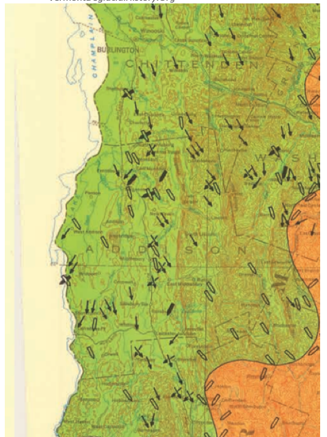
Stewart and MacClintock present striation and till fabric measurements in their State map, a portion of which is shown here:
Cannon (1964) examined striations in the Missisquoi Basin leading him to observe that these indicate a late glacial change in flow direction in conformance with the physiography.
Wright in his Charlotte report stated regarding striations (pp 9-10): “On outcrops where they have been preserved (most commonly on the sandstone members of the Monkton Formation), the common direction of glacial striations in Charlotte is approximately north–south (350 to 170). Elsewhere in the Champlain valley these N–S striations clearly cross-cut the NW–SE striations on outcrops where both sets of striations are preserved. The change in ice sheet flow direction most likely occurred when the ice sheet thinned sufficiently that its flow direction was constrained by topography, the north-south Champlain valley bounded to the west by the Adirondack Mountains and the east by the Green Mountains.”
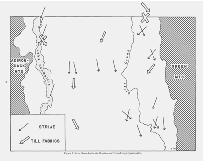
Connally in his Brandon -Ticonderoga report shows striation directions (Figure 3) likewise consistent with streaming as suggested above:
Thus, this directional evidence supports the findings reported here, that in T7 time the Champlain lobe in the Trough was a vigorous ice stream with southward, likely rapid flow.