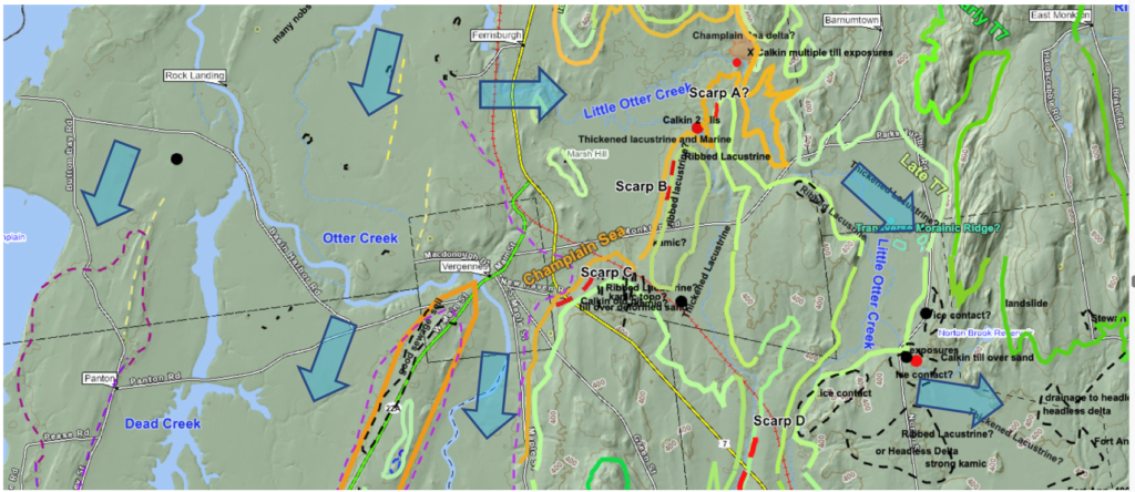
The following is a map of this basin from VCGI:
Obviously, there are many details which are difficult to read at this scale. Little Otter Creek again is one of the re-entrant basins in the Middlebury Bench. Only a portion of this basin, near the mouth is shown on this map. The Little Otter Creek Basin extends further to the east where the headwaters are close to Bristol, again where a major Gilbert type delta at the Coveville level is located, with Fort Ann features nearby to the west. This delta was formed by outwash from a T3-T6 step-down ice margin in T6 time. The early T7 margin in this headwaters area is associated with deposits related to the Fort Ann level and time, with the evidence indicating the triggering of calving of the Little Otter lobe tip at this time.
VCGI mapping prior to this Addendum indicated ice margins and associated recessional history similar to the LaPlatte Basin. Again, per the above map:
- Early T7 ice margin – darker green
- Late T7 – lighter green
- Champlain Sea – orange
As with other re-entrant basins, such as the LaPlatte and Lewis as just described, in early T7 time the Champlain lobe occupied the Little Otter basin in the Middlebury Bench and Trough, extending eastward to the foothills near Bristol, when Coveville Lake Vermont lowered to the Fort Ann level. This triggered calving represented by Ribbed Lacustrine deposits, Headless Delta deposits along the basin side walls, the latter graded to the Fort Ann level, and Thickened Bouldery Lacustrine deposits on the Basin floor, extending westward from the eastern early T7 margin to the late T7 margin.
The large blue arrows are intended to suggest the ice streams, both in the Trough area of the main basin and as well the Little Otter basin. And like its neighboring basins to the north:
- The path of the Little Otter ice stream was tortuous, requiring a substantial flow deviation from the main Basin ice stream.
- The deposits associated with and indicative of calving in this basin are scattered along the basin, indicating calving along the frontal tip and lateral margins of this ice stream in both early T7 time and continuing in late T7 time.
- Whereas recession of the calving margin is indicated, it is likely that the stagnant ice in the perimeter fringe deposits persisted, with recession of the frontal tip through T7 time, but that this recession occurred quickly over a short period of time.
The yellow dashed lines on the Champlain Basin floor in the western portion of the above map represent Streaks. Again, as with similar features as described above for Lewis Creek, the origin of these features could not be discerned from field examination, but they are compatible with southward flow in the main basin.
Four Scarps are identified near the mouth of the Little Otter Creek Basin, labeled as Scarps A-D. As with other re-entrant basins, no Scarps were found in the upper portion of this basin, which again is taken as related to less vigorous streaming of this ice stream owing to the tortuous flow path.
- Scarp A was not specifically examined.
- In the field , Scarp B marks a definite and obvious break in slope along the frontal edge of a distinct bench, with slight, possibly stagnant ice constructional topography. Small, shallow exposures along a small stream which traverses the deposit indicate silt-clay soils, with boulders on the stream bed. A local farmer confirmed the widespread presence of silt-clay soils. However, no information about the possible presence or absence of sand or gravel at depth was found.
- Scarp C is not obvious in the field. The black colored dashed lines near the Scarp which are barely discernible on the above map are intriguing. These were originally thought to be part of a Ribbed Lacustrine deposit but no topographic expression of stagnant ice is evident. The lines mark drainageways for present day small streams, and thus may simply represent postglacial erosion on the local sloping terrain. Shallow stream exposures in these drainageways show silt-clay soils, and boulder accumulations on stream floors indicating the boulderiness of the lacustrine soil. However, no information about the nature of deeper soils was found in this vicinity. Interestingly, these drainageways together have a splayed pattern along a north facing topographic convexity at the late T7 level. Similar splayed patterns have been identified at other locations where ice streams abutted and pressed firmly against the sloping terrain convexities. It is suspected that the occurrence of such patterns may indicate an important but as yet undetermined glacial dynamic. Such splayed crevasse patterns are reported in glaciology studies of modern glaciers and ice sheets, indicative of a stress pattern found at lobe tips but at this point these features in Vermont are not understood. Also interestingly and importantly, Calkin identified a gravel pit at the intersection of Plank Road and Route 7, which is on the face of Scarp C, reportedly with multiple layers of till separated by gravel strata. This pit was located on LiDAR and in the field but today is totally slumped and heavily treed, making it impossible to examine its geologic nature. However, Calkin’s description is consistent with lateral shearing of ice at the late T7 streaming margin, which is supportive of the explanation given above for Scarp formation.
- The fourth Scarp D is further south in Mud Creek Basin (off the above map) , a tributary to Little Otter Creek, suggestive of a tributary ice stream, but field examination provided no evidence supporting this Scarp. The topographic expression of this Scarp is not obvious in the field.
It is noted that Calkin’s report also identifies other exposures along the lower New Haven River, again with multiple tills. These are in locations consistent with shearing along the late T7 ice margin and ice stream in this basin. However, no present day exposures were found in this area. In general, the terrain in the lower basin is marked by numerous bedrock exposures, indicating the overburden soils tend to be thin and shallow.