The starting point for the examination of Vermont deglacial history was with the moraines in Quebec, as reported by Parent et Occhietti, with the Bath Tub Model in mind. Of particular interest were the Sutton (Sn) and Dixville (Dx) moraines, owing to their proximity to the Vermont border. This study finds that these margins correlate with ice margins in Vermont, The following is background information learned about these moraines, which is not needed in the body of this report but is included here as a matter of record.
Using digital graphics, the moraines depicted by Parent et Occhietti were superimposed on the following map:
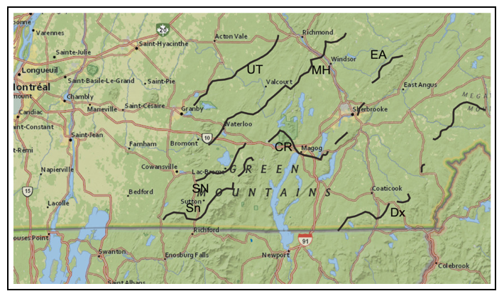
The moraines are indicated by the sinuous black lines, with the Sutton moraine(Sn) and the Dixville moraine(Dx) being most pertinent. Owing to the fact that different maps are based on various cartographic systems, the transposition from Parent et Occhietti ’s map locations to this map gives a reasonably good sense of their settings, but nevertheless is imprecise.
The following gives a closer, larger view of the Sutton(SN) and Dixville(DX) moraines:
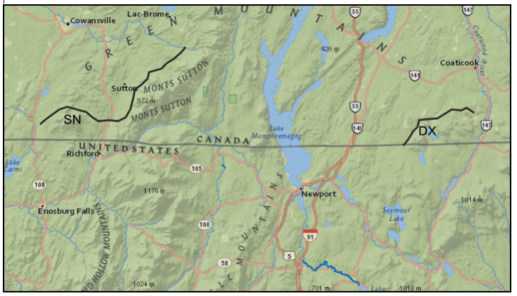
As can be seen, both moraines segments appear to be located at the base of upland terrain, indicating that they were formed by the ice sheet which pressed against these uplands as opposed to being free-standing. Based on the evidence from the study reported here for Vermont this reflects the close correspondence between the ice margin recession and physiography. This is evident, for example, for Ice Marginal Channels in the Memphremagog Basin and the Lamoille Basin, and for Bedrock Grooves along the east flank of the Champlain Basin. These features are interpreted as signifying their formation by confined meltwater along and beneath the margin of active ice. However, the Quebec features likewise in places are suggestive of stagnant ice, suggestive that these may represent “hybrid” margins similar to Vermont.
The elevations of these moraine ridge crests have not been found in published reports, and are difficult to determine from the above maps. Based on map contours, the elevation of the Dixville moraines is estimated to be about 1200 feet(366 m). A Perplexity search engine inquiry references Parent et Occhietti as indicating this moraine is at 396-427 meters(1300 – 1400 feet), but this elevation has not been confirmed. Thus, the Dixville moraine is believed to be in the 1200-1400 feet(366- 427 m) range. This elevation fits with the elevation of the T4 time and level in the Vermont deglacial history developed here.
At an early stage of VCGI mapping it became apparent that substantial stagnant ice deposits occur at an elevation of about 1200 feet in many valleys in the Memphremagog Basin. Thus, I began to think of a 1200 foot level(366 m), and a 1200 foot(366 m) time. The trace of the 1200 foot(366 m) elevation contour across the Memphremagog Basin comes close to but is not in good alignment with the Dixville moraine. Instead, Ice Marginal Channels at an elevation of about 1400 feet and as well stagnant ice deposits, near Holland Pond, basically around the corner of an upland from the Dixville moraine, at an upper elevation of about 1400 feet(427 m), appear to correspond with the reported elevation of the Dixville moraine. I examined Ice Marginal Channels, which, as noted above, I believe represent the active ice sheet margin. These are numerous in the Memphremagog Basin, clearly depicting ice margins at various levels in conformance with the physiography. When I traced the 1400 foot(427 m)Ice Marginal Channels, along the 1400 foot(427 m) contour, a much better alignment with the Dixville moraine was found. Thus, I began to think of a 1200-1400 foot(366- 427 m) ice margin as a “hybrid” type, which suggests that at any given time both an active ice margin and a stagnant ice margin existed, in close proximity, as is well known with modern day glaciers and ice sheets. This suggests that the Dixville moraine may correlate with a T4 1200-1400(366-427 m) foot hybrid ice margin level in VT.
Likewise, the elevation of the Sutton moraine is uncertain. It appears to be close to 800 feet(244 m), but is slightly lower where the moraine crosses river valleys. As can be seen on Parent et Occhietti’s map, two moraines are identified as “Sutton,” presumably representing ice margin retreat with two slightly different ages. The older, southernmost, and higher Sutton moraine lies at the base of an upland area – Monts Sutton – projecting toward the Vermont border in the vicinity of Lake Carmi. As with the Dixville moraine, the elevation is difficult to determine from the available maps. As discussed above, the exact correlation of ice margin levels in Vermont with the two Sutton moraines is uncertain but a general correlation with the T6 margin is suggested .