These are elongate, linear, ravine-like, fluvial meltwater erosional features, incised in bedrock terrain, formed along ice lobe margins, commonly extending across divides between local, small neighboring drainage basins. The Grooves commonly are tens of feet deep and hundreds of feet long, but in some places are much deeper and longer. They are related to drainage, tend to be associated with Drainage Lines, and commonly lead to kame deltas. As noted above, Bedrock Grooves are believed to have formed along active ice margins where and when the ice margin was firm and solid enough to impound or restrain surface water. Stagnant ice deposits in some places occur at the heads of Bedrock Grooves and in some places as well on Groove floors, but these deposits and their associated margins likely were not responsible for or associated with the original formation of the Grooves, but developed shortly thereafter.
Bedrock Grooves indicate the increasing importance of meltwater, beginning at an early time of deglacial history and increasingly so as deglaciation progressed. Bedrock Grooves are especially common and prominent 1) in northwestern Vermont along the western flank of the Green Mountains in the foothills generally at the mouth of and north of the Lamoille Basin; in this region they also are in close association with but not limited to the Shattuck Mountain Pothole Tract, as discussed below, 2) along the flank of the foothills at the floor of the basin at the mouth of the Missisquoi Basin near St Albans, Greens Corners, and Sheldon, as discussed in an open-letter to the Vermont State Geologist, in Appendix 5, and 3) on the of the mountain flank and foothills in the upland area generally east of South Hinesburg and Essex related to drainage along the receding margin at the time of Lakes Winooski and Mansfield, with several Grooves leading to drainage whereby the Lake Winooski drained to the Lake Mansfield level.
Bedrock Grooves likely formed by drainage along the ice margin, enhancing more erodible structural bedrock linear elements. Bedrock Grooves formed along the ice margin at a range of ice margin positions, beginning with earlier, higher levels, in some cases becoming deepened with time as the ice sheet surface lowered, but in many cases representing multiple receding ice margin positions. As just noted, many Bedrock Grooves include stagnant ice deposits on Groove floors, showing the associated stagnant ice margin presence with meltwater confined in and along the Grooves, likely as part of a hybrid margin.
Bedrock Grooves generally are part of the T4-T6 step-down ice margin sequences, south of the Winooski Basin, and the T4-T7 sequence to the north, representing a time in the deglacial history when meltwater was substantial, with earlier local proglacial lakes giving way to Coveville Lake Vermont to the south and Fort Ann Lake Vermont to the north.
Multiple Bedrock Grooves and associated Drainage Lines are marked by red arrows on VCGI maps. The screen shot below shows Bedrock Grooves in the Bakersfield area (in Locale CV4, as discussed in more detail below:
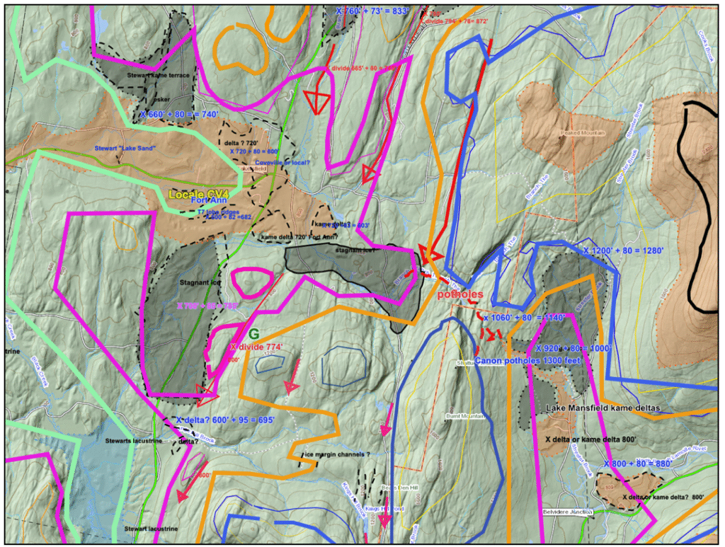
This is a working VCGI map, which as such includes a substantial amount of extraneous map information. Again, the red arrows represent Bedrock Grooves. As can be seen these tend to occur at divide areas between neighboring small drainage basins, with drainage from upgradient basins to downgradient basins across divides. The topography(or physiography) in this area is so irregular that in order to see the physiography thin yellow lines were added to mark the local 1400 foot (427 m) elevations, and thin blue lines to mark 1200 foot(366 m) elevations. Thicker lines represent ice margins at different times, with the thicker blue line marking the T4 ice margin and time, the orange line marking the T5 margin and time, the maroon line marking the T6 ice margin and time, and the sage colored line marking the T7 ice margin and time.
The bottoms of Grooves in this area tend to cluster at isostatically adjusted elevations of 800-900 feet(244 – 274 m) and 1200-1400 feet(366 – 427 m), which mark the T6 and T4 ice margins, respectively. The close association of Groove floors with ice marginal deposits and their predominant occurrence at or near the T6 and T4 levels supports the hypothesis that these are significant ice marginal features, marking the margin of the Champlain Valley ice sheet lobe on the western flank of the Green Mountains, related to local meltwater drainage which was diverted along the ice margin.
Another example of Bedrock Grooves is in the area east of South Hinesburg and Bristol, as shown on this screenshot from VCGI.
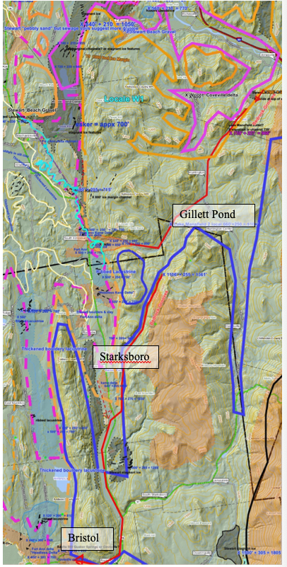
Again, the Bedrock Grooves are marked by red arrows. In general, these include:1) A southern set of Grooves east of Bristol, which indicate ice margin drainage leading to the Bristol delta. However, the bulk of the delta likely was from outwash from ice margins in the Starksboro area. 2) Multiple Grooves in the vicinity of Gillett Pond. Whereas the Gillett Pond groove likely was responsible for drainage for Lake Mansfield 1, as proposed by Springston et al, multiple Grooves in this vicinity suggest a progressive sequence of drainage from the uplands.
Bedrock Grooves are intriguing features meriting further, more detailed study.