“Scabby Terrain” is an ice margin feature characterized by a peculiar, rough texture on LiDAR imagery, which commonly occurs as scattered isolated patches on the landscape, but as well in multiple patches which together form elongate tracts. The “scabbiness” on LiDAR imagery has a more angular appearance, similar to but distinctive from stagnant ice deposits, with very irregular and uneven low relief, believed to be associated with loose, granular ablation-type till, with low grade, hummocky topography, which gives this feature its unique and distinctive signal on LiDAR. This is characterized by a chaotic multitude of bumps and dips of various heights(or depths) and widths, generally with the shapes of these elements in plan view being angular irregularities.
Scabby Terrain elements generally are random with no structural pattern, but in places include linear to curvilinear patterns suggestive of ice margins, and in places Scabby Terrain appears to grade into stagnant ice deposits with hummocky topography. In some places, “micro-eskers(?)” seem to be associated with Scabby Terrain. Scabby Terrain generally occurs in areas mapped as till ground moraine on the State surficial geology map, and commonly occurs at slightly higher elevations than associated stagnant ice deposits. In places, the distinction between the two is difficult to make, but in general Scabby Terran lacks typical smooth, rounded, and hummocky topographic expression of stagnant ice deposits on LiDAR imagery but instead has its peculiar geomorphic signal.
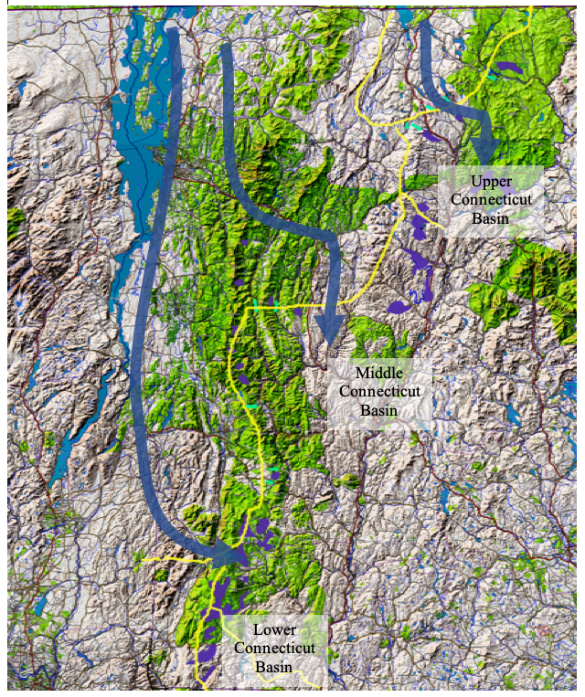
Scabby Terrain tracts occur in four locations in Vermont. Three of these occur in the Connecticut Basin, as shown by dark purple shading on the map below, in the Upper, Middle, and Lower Connecticut Basins. Some of the Scabby Terrain occurs as areas which are too small to be visible on this large scale, Statewide map. Major drainage basin boundaries are marked by yellow lines. For reasons explained below, ice supply for the ice masses in these basins was by major pathways, as schematically illustrated on this map, at low cols along the divides between the Memphremagog, Lamoille, and lower Champlain Basins into the Connecticut Basin, as suggested by the arrows. Owing to map scale limitations, the fourth Scabby Terrain tract which occurs along the western perimeter of Lake Winooski in the Winooski and Lamoille Basins is more difficult to see, although some of these patches are faintly visible.
At an early time in the VCGI mapping, before the origin and meaning of Scabby Terrain was understood, the peculiar texture of Scabby Terrain on LiDAR imagery was recognized in the northern Upper Connecticut Basin in the St Johnsbury area, and these areas were mapped as “Unknown.” This led to the recognition that together these patches form a tract. This tract was then recognized as correlating very closely, remarkably so, with an area mapped by Stewart and MacClintock (S & M) as one of their major Vermont moraines. The correspondence between the Scabby Terrain patches and Stewart and MacClintock’s moraine is virtually identical.
The Scabby Terrain related evidence in the Upper Connecticut Basin includes the following:
- The Scabby Terrain forms a tract in the St Johnsbury area which closely corresponds with S & M’s moraine.
- S & M mapped this moraine as till which they describe as having an unusually granular texture (suggestive of an ablation till).
- The Scabby Terrain is associated with stagnant ice deposits which also occurs as a tract at slightly lower elevations, generally on or close to the floor of this Basin, including a remarkable number of eskers (seemingly in almost every small basin within the Upper Connecticut Basin).
- The upper elevations of the Scabby Terrain and stagnant ice tracts are substantially lower than the mountainous upland terrain to the north in the narrow headwater area of the Upper Connecticut Basin.
- The Scabby Terrain and stagnant ice deposits occur in a lobe-shaped pattern or mass in the Upper Connecticut Basin corresponding with the physiography.
- This lobe pattern closes in on a lobe tip near Bradford at a S & M “moraine,” downgradient from which is a terrace (likely an outwash plain) graded to a Lake Hitchcock level delta.
- The Scabby Terrain and stagnant ice tracts together extend upgradient to, with the latter extending across, low col divides with the Memphremagog and Lamoille Basins.
- Ice Margin Channels, which indicate active ice presence, are mapped in these col divide areas in close association with but just above the elevations of the Scabby Terrain and stagnant ice deposits in these divides.
These observations all support and lead to the finding that the Scabby Terrain tract in the Upper Connecticut basin represents en masse stagnation of a large, previously active ice mass, caused by a Disconnection from the parent ice sheet to the north and west of feeder ice streams, which resulted when the ice sheet thickness at these cols during deglaciation lowered to the point at which active ice supply to the Upper Connecticut Basin no longer was sustained. Such Disconnections similarly are identified in the Middle and Lower Connecticut Basin, resulting in en masse stagnation as marked by Scabby Terrain in those basins. This evidence indicates that during deglaciation essentially the entire ice mass in the Connecticut Basin in Vermont progressively stagnated en masse at three times.
The Ice Marginal Channels, stagnant ice deposits, and Scabby Terrain in this Basin at the T3 and T4 levels correlate with features at the WMMS.
Looking ahead, it will be shown that the earlier Disconnections are marked at T1 and T2 positions in the Lower and Middle Connecticut Basins, respectively, and that the third Disconnection occurred following a readvance in T3/T4 times, as evidenced by a correlation with the White Mountain Moraine System in New Hampshire, as discussed elsewhere herein. Further, that this readvance is marked by ice margin features including Ice Margin Channels and associated stagnant ice deposits at the T3 and T4 times and levels which are mapped across Vermont as a “signature” pattern, and that these margins can be correlated with features reported by others in Quebec and New York. In essence, the entire ice mass in the Connecticut Basin in Vermont, representing approximately 40 per cent of the entire area of the State stagnated en masse by three successive disconnections.. Not shown on the above map is a similar Disconnection associated with the perimeter of Lake Winooski along its western perimeter in T4 time.
The evidence from VCGI mapping presented in this report, in conjunction with evidence presented previously by others, all as discussed in substantial detail elsewhere in this report, indicates that at an early time at the beginning of the Lobate Phase in Vermont , following recession of the Laurentide ice margin for an undetermined retreat distance, the ice sheet readvanced, likewise necessarily for a distance which is unknown, to T3 and T4 margin positions as mapped here in the southern Champlain Basin. The T3 and T4 positions are correlated with a) the WMMS in New Hampshire as reported by Thompson et al, b) the T3 margin with the Dixville moraine and the T4 with an older but as yet uncertain ice margin in Quebec as reported by Parent et Ouchietti, and c) in New York to ice margin positions 1 and 12, respectively, as reported by DeSimone and LaFleur. Readvance evidence consistent with this T3/T4 redvance was also reported previously by Wright and others, again as discussed below, in the Winooski Basin, and in multiple reports in the Vermont Valley, although DeSimone and LaFleur specifically state that no such readvance evidence was found by them in New York.
Thus, Disconnections and Scabby Terrain tracts are quite significant elements in the deglacial history of Vermont. Whereas the full deglacial history and significance of Scabby Terrain as just stated was not initially recognized and understood, the recognition of the above Scabby Terrain evidence as an indicator of en masse stagnation led to an online search of the glaciology literature, to an article by Davies et al(2022) 1 www://onlinelibrary.wiley.com/doi/10.1002/esp.5383, https://doi.org/10.1002/esp.5383 Davies et al, B., Bendle, J., Carrivick, J. et al.(7 more authors)(2022) Topographic controls on ice flow and recession for Juneau Icefield(Alaska/British Columbia). Earth Surface Processes and Landforms, 47(9). pp. 2357-2390. ISSN 0197-9337 about “Disconnected” portions of ice sheets and glaciers, with descriptions that fit the St Johnsbury features as a tract marking the upper margin of an entire Disconnected ice mass in the Upper Connecticut basin. Subsequently, as already stated, the two other similar tracts were then identified and mapped at different levels in the Lower and Middle Connecticut Basin, out of which came the recognition that these tracts likely represent Disconnections of entire portions of the ice sheet in the Lower, Middle, and Upper Connecticut Basin in Vermont, essentially as en mass stagnation, caused by lowering of the ice sheet surface at physiographic divides, when and where the ice supply to downgradient ice masses ended, with en mass stagnation of the downgradient mass resulting at three different times subsequent to the aforementioned readvance. The VCGI maps show locations where ice flow across low cols was associated with Disconnections.
The fourth tract of Scabby Terrain corresponding with the western perimeter of proglacial Lake Winooski (which in its day was a large, isolated proglacial water body in the uplands on the scale of present day Lake Champlain), as mapped by Springston, et al 2ibid This represents a different Disconnection mechanism, whereby ice masses in deeper basins on the eastern flank of the Green Mountains, upgradient from and along the western perimeter of Lake Winooski, became Disconnected by the action of standing water penetrating along the margin of Lake Winooski. This speaks to the effectiveness of standing water penetration along the ice sheet margin, which is similar to the evidence along the eastern margin of the Champlain lobe where a narrow, open water corridor developed along a “Disaggregated” ice margin associated with the Coveville, Fort Ann, and Champlain Sea levels, as discussed below. This was associated with the development of calving ice margin shelf and other features which represent the rapid demise of the destabilized Champlain lobe, again as discussed in detail below. Ice margin features on the eastern margin of Lake Winooski likewise provide evidence of rapid retreat related to penetration of lake waters along an ice margin, but without evidence of associated Scabby Terrain. At multiple locations along this eastern margin, scattered present-day lakes with unusual water depth are mapped on VCGI in close association with stagnant ice deposits with esker drainage extending downgradient to kame delta deoosits at the Lake Winooski level. This evidence indicates that scattered, isolated blocks of ice were left behind, essentially in kettle holes by rapid recession of the ice margin in close association with Lake Winooski. A similar pattern is found in the Memphremagog Basin in conjunction with proglacial Lake Memphremagog. Likewise, in the Champlain Basin, as just stated above, a similar pattern is found. In general, such evidence indicates rapid recession in conjunction with the penetration of standing waters along proglacial water body strandlines, albeit such features formed at different times in the deglacial history. In the Memphremagog Basin this pattern is mapped in conjunction with the diffrentiation between stagnant and active ice margin features as part of a “hybrid” type ice margin related to a Style termed “Everything, Everywhere, All at Once , and Continuing.”
Thus, Scabby Terrain tracts are seen as a significant part of a larger story, which is not just about deglacial history, but also about “Glacial Dynamics” and a Style of deglaciation which, again, has significant implications for today’s global warming.
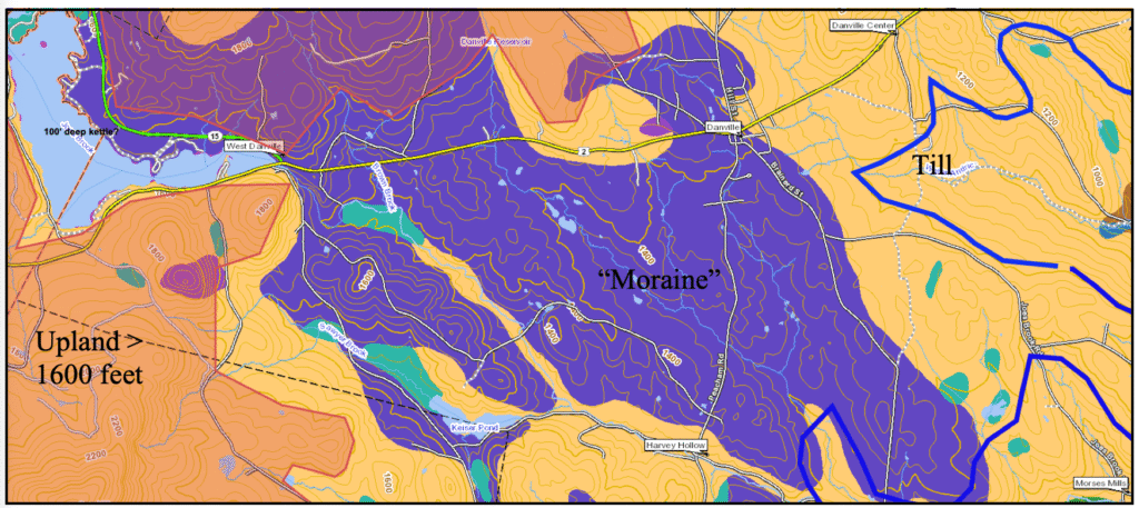
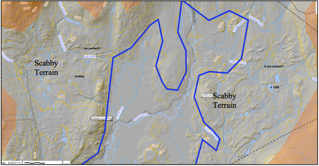
A close up example of Scabby Terrain is in the Danville area, just east of Joes Pond, along the western flank of the Connecticut Valley. The map below is from the surficial geology tab on VCGI including a portion of Stewart and MacClintock’s “St Johnsbury moraine.” The blue line marks the 1200 foot(366 m) contour and the russet colored area is added, to show upland areas above 1600 feet(488 m). The yellow colored area is S & M’s designation for till and the purple colored area is S & M’s moraine. Where the moraine extends into the VCGI markup for terrain above 1600 feet(488 m), the moraine color is altered to a lighter lavender.
The map below is a portion of the same area with LiDAR imagery, showing typical Scabby Terrain, corresponding with S & M’s moraine.
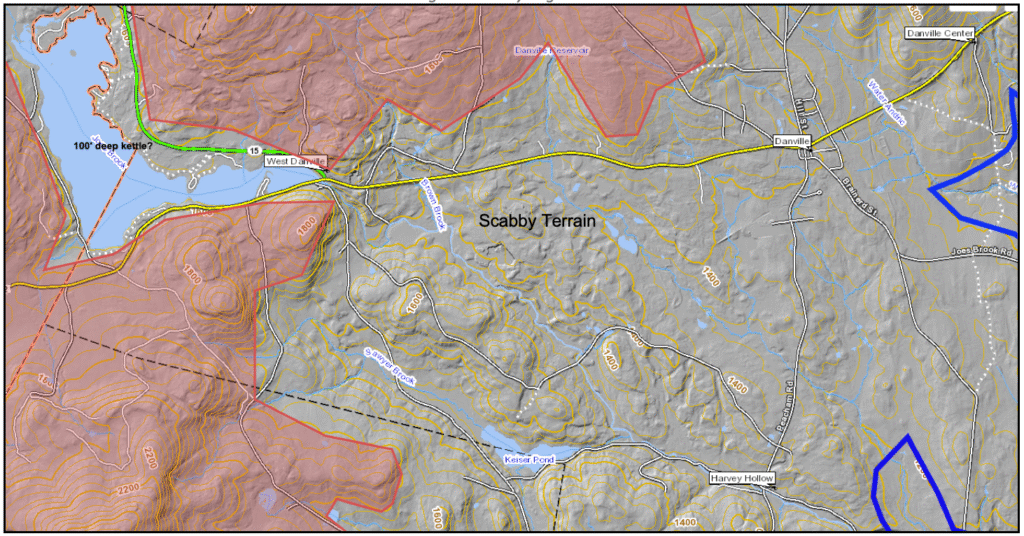
The characteristic, peculiar texture of the Scabby Terrain on LiDAR is evident, which, again, differs from the more pronounced and rounded forms associated with stagnant ice deposits.
Another example is in the Island Pond area at the divide between the Clyde River and Nulhegan River:
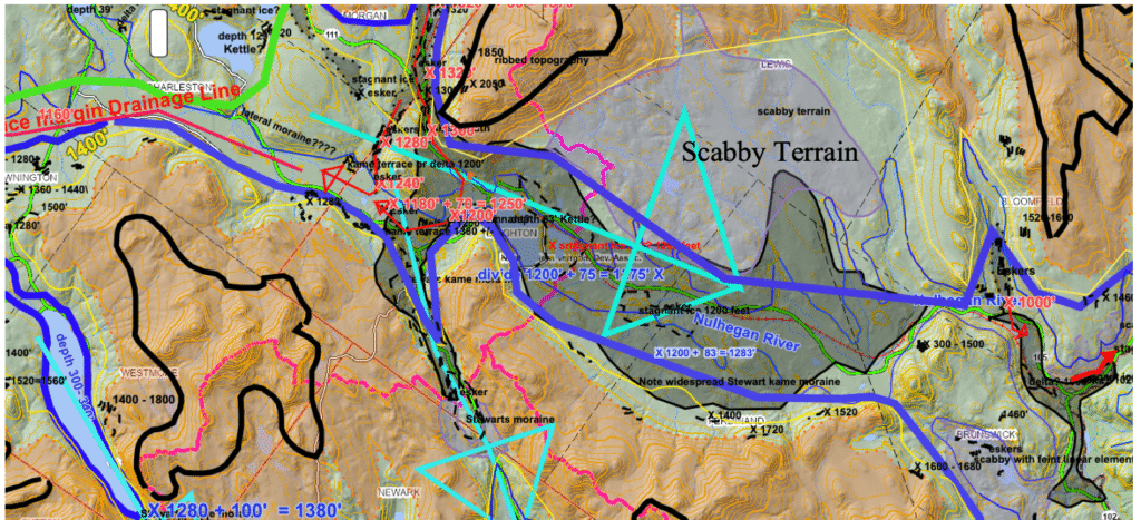
Again, the heavy black lines mark the 2000 foot (610 m) contour, the russet colored area indicates terrain above 1600 feet(488 m), and the thin yellow line marks the 1400 foot (427 m) contour. The lavender colored line marks the regional physiographic divide near the village of Island Pond between the Clyde Basin as part of the Memphremagog Basin and the Nulhegan Basin which is part of the Connecticut Basin. This map includes a substantial amount of detailed geologic information from VCGI mapping, but the focus here is on the large tract of Scabby Terrain marked by the light purple colored shading in the circular shaped depression in the divide area. By way of explanation, Ice Marginal Channels (identified and marked as dashed black lines, show that an active ice mass extended across the divide in this area at elevations which vary but generally are in the range of about 1400-1700 feet (427-518 m), which is close to but just below the T3 level. The dark gray area which extends across the divide corresponds with a stagnant ice deposit, as marked on the Stewart and MacClintock map and confirmed independently by VCGI mapping. The elevation of the stagnant ice deposit is about 1200 feet (366 m), which is marked by the thin blue line, at the T4 level. Using elevations established for T levels, times, and ice margins the stagnant ice deposit corresponds with the T4 ice margin, which in many places is identified as a hybrid margin, consisting of an upper active ice margin, and a slightly lower stagnant ice margin. Thus, this evidence indicates that active ice extended across this divide in T3 and T4 time, as signified by the large turquoise colored arrows, serving as ice supply from the Memphremagog Basin into the Connecticut Basin. As the ice sheet lowered, the ice thickness became insufficient to sustain flow, resulting in the Scabby Terrain and stagnant ice deposits. This pattern is repeated for multiple pathways between the two basins, with the Scabby Terrain indicating a Disconnection of the ice sheet in the Connecticut Basin. Significantly, the T3 and T4 margins are correlated with the White Mountain Moraine System as mapped by Thompson et al in New Hampshire, as noted above and discussed below.
A third example is from the Victory Bog area, just east of Lyndon, in the Connecticut Basin:
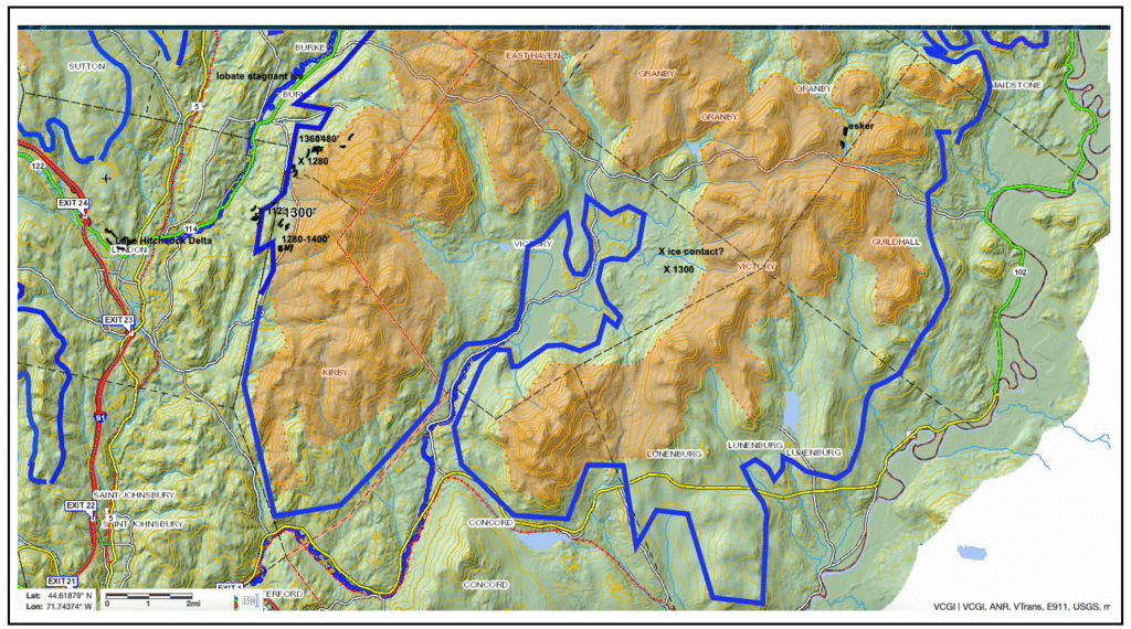
Again, the russet area is terrain above 1600 feet(488 m) and the blue line marks the 1200 foot(366 m) contour. The Connecticut River is along the right side. Victory Bog is in the central lowland area, encompassed by horseshoe shaped uplands. The map below is the same area with LiDAR imagery. Unfortunately, due to quirky functioning of VCGI, the entire area as in the above is not visible on LiDAR.
Scabby Terrain is labeled, portions of which resemble stagnant ice deposits, suggesting a similar or related mode of origin, Again, the Scabby Terrain is part of the evidence for en mass stagnation of the ice mass in the Connecticut Basin at T4 time , as marked by the heavy blue line
The screen shot below shows an early version of the VCGI map of the upper Connecticut Valley:
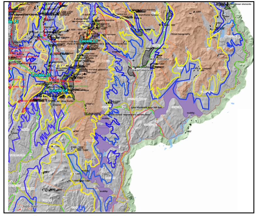
The lavender colored areas mark mapped areas of Scabby Terrain, and as stated, likewise correspond closely with S & M’s moraine. Again, the blue line marks the 1200 foot(366 m)contour, the yellow line the 1400 foot (427 m) contour, and the russet areas indicate terrain above 1600 feet (488 m). Scabby Terrain in this area generally lies below 1200 feet (366 m) but, in some places, extends to 1400 feet(427 m). As stated above, Ice Marginal Channels are not numerous in the Connecticut Basin, but are found at scattered locations in divide areas showing the presence of an ice lobe active ice margin levels conforming with the topography from about 1800 feet(427 m) downward to about 1200 feet(366 m). This is taken as indicative of active ice prior to the Disconnection, including the T3/T4 readvance correlated with the WMMS.
Taken together, the fact that the Scabby Terrain in the Upper Connecticut Basin at the T4 level extends downward in elevation from Ice Marginal Channels, with the stagnant ice deposits below, which in turn extend downward in elevation to the Basin floor, and further that these deposits extend from divides shared with the Memphremagog Basin southward to Bradford vicinity, all of this at elevations below the level of terrain in the very narrow Connecticut Basin to the north, establishes that the ice sheet in T4 time stagnated en masse owing to a Disconnection. Bearing in mind that the ice mass in the upper Connecticut Basin was, of course, associated with and sustained by the Laurentide ice sheet, it is clear from considering the physiography that an ice mass in the Upper Connecticut Basin at the 1200 -1400 foot (366-427 m) levels could not possibly have been connected with and nourished by the ice sheet to the north. This resulted in the Disconnection, again when the level of the ice sheet fell such that active ice supply was no longer sustained.
As noted above, a brief review of online literature led to several article by Davies et al and others.3 For example, in an online Wiley Journal: Bethan Davies et al, Jacob Bendle, Jonathan Carrivick, Robert McNabb, Christopher McNeil, Mauri Pelto, Seth Campbell, Tom Holt, Jeremy Ely, Bradley Markle, 2022, Topographic controls on ice flow and recession for Juneau Icefield(Alaska/British Columbia); www://doi.org/10.1002/esp.5383 These authors describe “glacier disconnections,” where glaciers become separated from their accumulation areas, and as a consequence become stagnant, with disconnected ice masses tending to accumulate more sediment debris on their surface. It is suggested here that this is the explanation of the origin of the Scabby Terrain in the upper Connecticut Basin and elsewhere as discussed further in the deglacial history section below.
The Scabby Terrain tract in the upper Connecticut Basin extends over a distance of about 40 miles. The Scabby Terrain tract in southwestern Vermont, basically extending northward from the Vermont/Massachusetts border to approximately the latitude of Middlebury, also covers a distance of about 40 miles. Both the upper Connecticut Valley and southwestern Vermont Tracts of Scabby Terrain are mappable, with very significant implications for the deglaciation history of the entire State. In general, again such Disconnections occurred when the ice sheet surface fell to levels across divides where and when ice thicknesses became insufficient to sustain flow from the parent Laurentide ice sheet to ice masses on the downgradient side of the divides.
In addition to the above examples, Scabby Terrain deposits are also described in connection with various Locales, as discussed in Appendix 2, as for example at Locale LC1 in southern Vermont in the Lower Connecticut Basin, at Locales CB1 and MC1 in central Vermont, at Locales W2 and W3 in relation to Lake Winooski, at Locales L1 and L2 in the Lamoille Basin, and at Locale M2 in the Memphremagog Basin.
Finally, it is noted that Scabby Terrain also occurs in many places as localized patches, as identified on the VCGI map in the Memphremagog Basin. The origin, meaning, and significance of such isolated patches is puzzling. One hypothesis is that they may be more common on the lee sides of local upland knob-like areas where erosion by abrasion on stoss sides and plucking on lee sides might have result in higher than “normal” sediment loading in the ice sheet on the lee sides, and where local disconnections may have occurred, as for example below ice falls, in the manner described by Davies. However, at this juncture the origin and significance of such local patches remain uncertain.
Footnotes: