The screen shot below shows the VCGI map for this Locale. This Locale is located in the southwestern corner of the State. The village of Bennington is just off the southwest corner of the map. The primary feature in this Locale is a 17 mile long Scabby Terrain tract, marked by light purple shading on the map, at an adjusted elevation of 2700-3120 feet(823- 978 m), or local elevations of about 2000 -2420 feet(610- 738 m), which establishes the T1 ice margin marked by the orange colored line. 1 As noted above, “local elevations” refer to present day elevations without adjustment for isostatic rebound gradient differences. Elevations of certain specific features have been adjusted for this difference, by addition of an amount calculated using a gradient of 5 feet per mile(0.05 m/km) based on the distance to the Canadian border on a north-south transect. These adjusted elevations are shown on the VCGI maps by the local elevation plus an adjustment amount, which for the Deerfield Basin is on the order of about 750 feet(229 m), the exact amount varying with distance to the Border. The Scabby Terrain Tract is within the lower Connecticut(Deerfield) Basin, near it’s divide with the neighboring Hudson-Hoosic Basin to the west, which was occupied by the Champlain Lobe of the ice sheet.
The following map shows the VCGI mapping in this Locale.
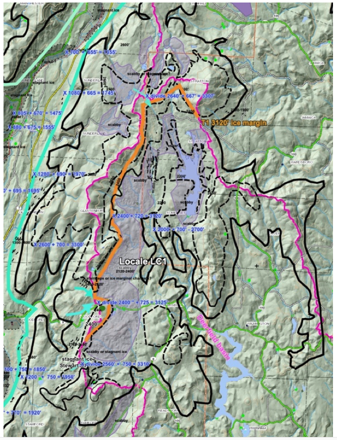
The terrain in this Locale is difficult to see or visualize. As an assist:
- Drainage basin boundaries are marked by purple colored lines on the VCGI map.
- A heavy solid black line marks the 2000 foot(610 m) local elevation, and a thinner dashed black line marks the 2400 foot(732 m) local elevation. 2 Adjusted elevations are about 750 feet(229 m) higher than “local” elevations, which again reflects the isostatic rebound correction. The Scabby Terrain tract generally lies within this elevation range.
- To the west is Bennington which is at the head of the “Vermont Valley,” a long narrow trough-like valley between the Taconics on the west and the Green Mountain front range on the east, basically a southward extension of a physiographic appendage of the Champlain Basin from Rutland southward, across a divide with the Hudson/Hoosic and Metawee drainage basins near Manchester. The local elevation of the floor of the Vermont Valley in the Bennington area is at approximately 1200 feet.
- The crest of the Green Mountain front range east of Bennington is a narrow upland plateau with irregular topography, including small, shallow basins, generally in the 2400 -2600 foot(732 -792 m) local elevation range. The Scabby Terrain tract is in low areas in this upland plateau, in the headwater area of the Deerfield Basin portion of the Connecticut Basin. The Scabby Terrain tract generally lies within this elevation range. The crest of the Green Mountain front range east of Bennington is a narrow upland plateau with irregular topography, including small, shallow basins, generally in the 2400 -2600 foot(732 -792 m) local elevation range. The Scabby Terrain tract is in low areas in this upland plateau, in the headwater area of the Deerfield Basin portion of the Connecticut Basin.
The T1 ice margin is shown on the above map by the orange colored line, along the western margin of the Scabby Terrain Tract. This margin marks the highest elevation of the Scabby Terrain but not the oldest and highest Lobe Phase ice margin position in Vermont at that time, which was located near the regional physiographicm along the ice margin for the Champlain lobe where and when ice supply to the Lower Connecticut Basin ended. Scabby Terrain indicates a Disconnection of the ice mass in the Lower Connecticut Basin from the parent Champlain lobe of the ice sheet in the neighboring Vermont Valley. The Disconnection occurred when the level of the ice sheet fell at cols along the basin divide separating the tract from its parent ice sheet, such that active ice flow across the divide could no longer be sustained.
The thickness of the ice in the Vermont Valley when the Scabby Terrain Tract formed in Locale LC1 was slightly more than about 1200 feet, but as discussed below was much less on the upland plateau where the Scabby Terrain formed. The issue of ice thickness is important in regard to the usage and viability of the Bath Tub Model being favored by thinner ice. This raises the question as to how thin the ice sheet needs to be in order to justify the use of the “Model.” Obviously, this is not a matter of choosing a single thickness but is a relative matter, related to the relief of the terrain. Whereas the 1200 foot(366 m)thickness might seem to be relatively thick, obviously the terrain differences associated with the Vermont Valley are substantial. By contrast, for example, the T7 margin in the vicinity of Fairfield Pond shows remarkable sensitivity to terrain differences, with ice thicknesses on the order of 200 feet(61 m), which obviously is relatively thin ice(just as the vertical relief in that area is much less than in the Vermont Valley). In general the Bath Tub Model was used for ice thicknesses within the range of 200 to 1200 feet(61 – 366 m), but again the justification is dependent on the relative relief.
In general, the Scabby Terrain Tract in Locale LC1 occupies the floors of the small upland basins immediately below about the 2400 foot(732 m) local elevation, but generally above the 2000 foot local elevation. The upper, adjusted elevation of this tract and ice margin is about 3120-2700 feet(951 – 823 m), as indicated on the tabular summary and as shown on the Statewide map. In northern Vermont this elevation is in the high peaks, above the highest Ice Marginal Channels, indicating, as expectable, that deglaciation progressed earlier and was more advanced in southern Vermont.
A closer examination of the divide separating the Lower Connecticut Deerfield Basin from the Hudson-Hoosic basin shows lower elevations at cols, suggesting ice flow into the Deerfield Basin from the Hudson-Hoosic basin at these cols, as marked by sage colored arrows, along with local elevations ranging from about 2400 feet to 2640 feet(adjusted elevations 3120 feet to 3307 feet). The Disconnection likely occurred when the level of the ice sheet fell to a level where the thickness of ice across these cols was insufficient to sustain active flow. Assuming this thickness may be about 300 feet, the elevation of the ice sheet at T1 time may have been about 3400-3600 feet.
The orange colored line on the above VCGI Locale LC1 map at an adjusted elevation of 3120 feet, extends approximately along the upper boundary of the Scabby Terrain Tract, mostly immediately below and on the east side of the regional basin divide. This Tract marks the western margin of the Disconnected ice mass on the immediate lee side of the Disconnection, where sediment supply in the ice from erosion at the divide likely was more substantial, in the manner described by Davies et al.
This upland area was, of course, totally ice covered at the glacial maximum. Ice Marginal Channels and possible Drainage Lines on the eastern flank of the Vermont Valley, immediately west of this Locale, indicate occupation of this area by active ice of the Champlain lobe. It is obvious, therefore, that the development of the Lobe Phase in this area was part of the Champlain Lobe, including its extension into the Connecticut Basin, specifically into the Deerfield Basin via the Hudson-Hoosic basin prior to T1 time. The Scabby Terrain which marks T1 time and level in places includes topographic patterns, including a possible micro-esker and curvilinear patterns suggestive of stagnant ice. The Scabby Terrain Tract is mapped as till ground moraine on the State Surficial Map, and on LiDAR shows a signal typical for Scabby Terrain. Much of the deglaciation history for T1 time presumably is to the south in the Deerfield Basin in Massachusetts, beyond the VCGI map area.
The Scabby Terrain in the small, shallow basins in this upland plateau underscores the importance of physiography in controlling not only the shape of ice margins but also the ice flow pathway connections to the main Laurentide ice mass, in this case the Champlain lobe. Whereas the thickness of the Champlain lobe in the Vermont Valley may have been about 1200 feet, the ice thickness on this upland plateau when the Scabby Terrain formed was much less and likely quite thin. The T1 Scabby Terrain reflects both deglacial history and as well indicates a Glacier Dynamic as a marker of the upgradient margin of the Disconnected ice mass in the Lower Connecticut(Deerfield) Basin. The accumulation of debris at upgradient margins of Disconnected ice is consistent with observations and explanations given by Davies et al. The margin of this Disconnected ice mass is not traceable further north in Vermont, but the level of the ice sheet further north at the time when the connection occurred can be examined. As noted above, the highest Ice Margin Channels marking the Nunatak Phase in northern Vermont are at adjusted elevations of about 2000 feet, versus about 2700 feet in central Vermont east of Rutland. Thus, the Disconnection at T1 time occurred at an earlier deglaciation time, likely before the earliest Nunatak Phase record thus far found in Vermont. Many of the higher peaks of the Green Mountains are above the elevation of the T1 level and thus likely were early nunataks before this time. The absence of Ice Marginal Channels at the T1 level in northern Vermont likely reflects the shallowness of soils at these high elevation and perhaps limited meltwater at this time.