a. Overview
Six Locales are identified in the Lamoille Basin. Ice Marginal Channels, substantial stagnant ice deposits, Drainage Lines, and other features indicate that a Champlain Basin sub-lobe extended eastward into the Lamoille Basin from the parent ice sheet, through a major physiographic gap in the Green Mountains near the villages of Cambridge and Jeffersonville, into a lowland in the Morrisville /Stowe/Waterbury area where for a while the lobe was conjoined with the Winooski lobe to the south. The Lamoille lobe extended eastward, past the Worcester Range and another smaller upland south of Wolcott, to the vicinity east of Hardwick where the lobe abutted against the western flank of a substantial upland in the Towns of Cabot, Walden, and Stannard, and northward into tributary valleys, toward and in some cases across divides to conjoin with the Memphremagog lobe and the Connecticut lobe.
The deglacial history of the Lamoille Basin, as mapped on VCGI and depicted on the Statewide map, is similar to the Winooski Basin, with:
- Early nunatak development, as suggested by ochre shading for elevations above 1600 feet on the VCGI map, with Nunatak Phase elevations marked by numerous Ice Marginal Channels from elevations of about 2000 feet to 1400 feet, showing the progressive recession of the ice sheet in conformance with the physiography. The highest of these correlates with the T3 ice margin in southern Vermont, the earlier and higher T1 and T2 ice sheet levels and margins presumably being at higher but unmarked nunatak elevations.
- The T4 1200 – 1400 foot (366 – 427 m) ice margin(heavy blue line) in the Lamoille Basin is marked in many locations at this level by widespread stagnant ice deposits, some of the more prominent of which are shaded in gray on the VCGI map.
- The T5 1000-1100 foot(305 – 335 m) level ice margin(heavy orange line) is likewise marked by stagnant ice deposits and drainage features at this level, as shown on VCGI and Statewide maps.
- The T6 800-900 foot(244 – 274 m) and T7 600-700 foot(183 -213 m) ice margins and levels extended into the Lamoille Basin, as marked by maroon and sage colored lines on VCGI and the Statewide map.
- By T8 500 foot(152 m) time the ice sheet had receded from the upland interior of the Lamoille Basin and stood further to the west.
- The Lake Winooski strandline is associated with the T4 ice margin, and the Lake Mansfield strandline with T5 and perhaps T6 margins, as marked on the VCGI map. The Lake Winooski and Lake Mansfield footprints are presented on Statewide maps.
Wright et al have developed substantial information about the deglacial history of the interior upland areas in Vermont, including in the Winooski, Lamoille and Memphremagog Basins. Whereas this has been examined, much of which was relied on and generally fits with the interpretation given here, minor differences in some details are recognized.
The Lamoille Basin historical record spans a substantial part of the entire deglacial history of Vermont. This can be seen in the basin as a whole, but even within sub-basins; for example in the North Branch of the Lamoille sub- basin, step down ice margins are indicated “like multiple rings in a slowly draining bath tub.” In the following, detailed aspects of this history are reviewed for selected Locales.
b. Locales L1 and L2
Locale L1 is in the headlands of the Lamoille basin extending from the East Hardwick area eastward to uplands in a divide area between the Lamoille, Memphremagog, and Connecticut Basins, where the Lamoille ice lobe T4 1200-1400 foot(366-427 m) ice margin abutted against substantial uplands marking the divide with the Connecticut and Memphremagog Basins. Locale L2 is about 10 miles to the southwest, down valley from L1. These Locales are discussed here together to illustrate the progressive deglacial progression in this area. The following VCGI map is for both of these Locales:
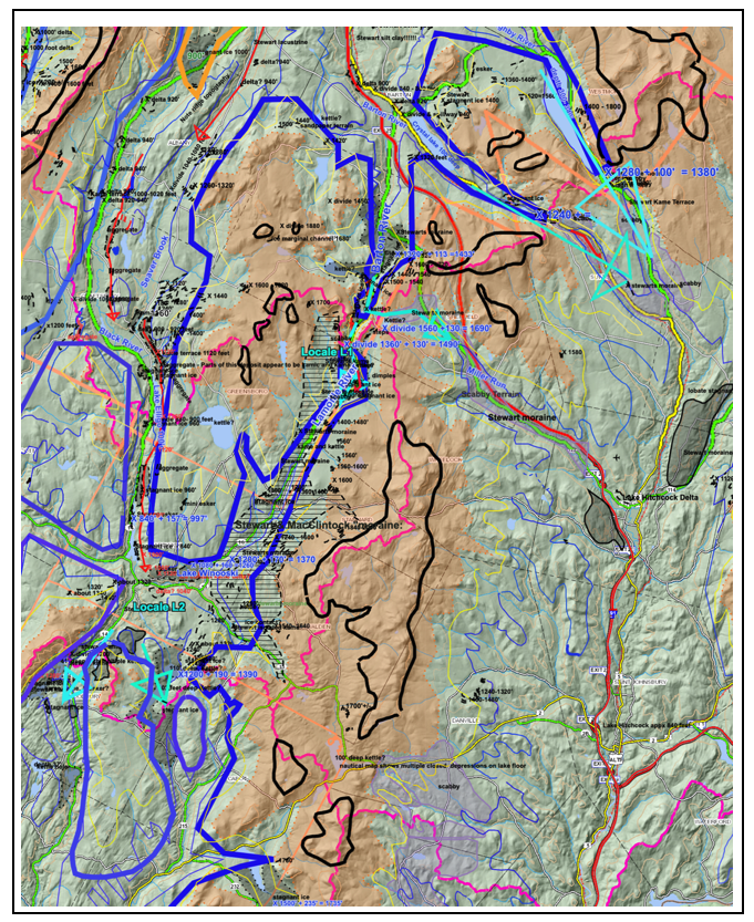
Basin boundaries are marked by purple lines. Present day elevations above 1600 feet are shaded in ocher color, the 2000 foot(610 m) elevation contour is marked by the solid black line, the 1400 foot(427 m) elevation by the thin yellow line, and the 1200 foot(366 m) elevation by the thin blue line. Not all such elevations are mapped. Again, owing to the quirky scalar nature of VCGI, contour lines and the ice margin boundaries drawn on VCGI are approximate.
In the upper Lamoille Basin, between Locales L1 and L2, Ice Marginal Channels, as marked by thin black dashed lines, many with present day, “local” contour elevations, are especially numerous. These features demarcate the progressive lowering of the ice sheet in the Nunatak phase and development of the Lamoille lobe in conformance with the terrain, from an elevation at the top of the Nunatak Phase at a local elevation of about 2000 feet(adjusted elevation of about 2200 feet) downward to the bottom of the Nunatak Phase at about a local elevation of about 1200 feet, adjusted elevation 1400 feet.
Based largely on LiDAR imagery, plus other VCGI tabs, stagnant ice deposits, as demarcated by gray shading and in places by a horizontally ruled pattern, are mapped on both sides of the divide area between the Lamoille and Memphremagog Basins(specifically the Barton Basin) near L1(which is at an adjusted elevation of about 1490 feet) and the upper Lamoille Basin. These deposits, representing the T4 1200-1400 foot 366 – 427 m) ice margin, are marked by the heavy blue line, indicating commingling of ice between the Lamoille, Memphremagog, and Connecticut Basins prior to, but separating in T4 time. Such co-mingling at valley heads as marked by stagnant ice deposits on both sides of divides at this level between the Lamoille and Memphremagog Basins is typical, indicating the T4 ice margin began to form separate lobes in the Lamoille and Memphremagog Basins in headland areas at this time, with overdeepened basins at the heads of Memphremagog Basins. As indicated in the text at multiple places, the comparison with the Finger Lakes region of New York, with “Valley Heads” moraines at such divides, including long, narrow over-deepened basins is striking and deserves further study.
In contrast, Scabby Terrain, marked by the pale lavender shading on the above VCGI map typically occurs in headland areas of the Connecticut Basin across divides between the Lamoille and Memphremagog Basins, with stagnant ice deposits at slightly lower elevations, indicating Disconnection of the ice mass in the upper Connecticut Basin at T4 time. For example, Scabby Terrain is shown by lavender shading in the Miller Run basin(marked on the above map), a tributary to the Passumpsic in the Connecticut Basin, with much more substantial tracts in the Connecticut Basin, beyond the Locale L1 map area.
The large sage colored arrows on VCGI are intended to signify ice flow across the divides at low cols, from the Memphremagog Basin into the Lamoille and Connecticut Basins.
Drainage Lines, again identified on LiDAR imagery and marked by red arrows in divide areas suggest meltwater drainage patterns, including drainage extending across divides. Again, kettle holes are common in divide areas at the stagnant T4 margin, including Clarks Pond(72 feet deep), Horse Pond(4 feet deep), and Bruce Pond(13 feet deep).
The horizontally ruled area at Locale L1 marks irregular terrain mapped by Stewart and MacClintock as “moraine,” which they extended southward across a divide and correlated with their moraine which they mapped in the Connecticut Basin, from headwater areas southward in the Passumpsic basin to the Bradford area. In their report Stewart and MacClintock remark that this is among the best examples of moraines in New England(along with their Rutland and Bennington moraines). This feature is mapped on VCGI as multiple Ice Marginal Channels in the Lamoille Basin and as Scabby Terrain in the Connecticut Basin. Thus, the interpretation here regards these features as separate ice margin markers of an ice lobe in the Lamoille Basin, separate from the Connecticut Basin. As described by Stewart and MacClintock, the feature they identify as moraine in the Connecticut Basin typically has hummocky topography but is composed of a gravelly ablation type till. The mapping of Scabby Terrain in the Upper Connecticut Basin as reported here was done at an early time, prior to examination of the Stewart and MacClintock map. The occurrence and distribution of Scabby Terrain, in the Connecticut Basin as mapped on VCGI, is remarkably similar to Stewart and MacClintock’s moraine. Whereas the nomenclature differs, either way an ice margin is indicated, but of course the Scabby Terrain Disconnection story itself is a significant finding.
Locale L2 is in the divide area between the Lamoille and Winooski Basins, just north of Locale W3. Similar to L1, stagnant ice deposits, kettle holes(including several with substantial depth), and Drainage Lines, mark the T4 1200-1400 foot(366 -427 m) ice margin, in this area on both sides of the divide, indicating commingling with incipient separation of the Lamoille and Winooski lobes. The L2 area is in a low col along the divide, with southward ice flow indicated diagrammatically by the large sage arrows. Drainage along the ice margin was generally southward as indicated by the red Drainage Line arrows.
As can be seen on the above VCGI map, just north of the Locale L2 label is Alder Brook, a tributary to the Lamoille, which joins the Lamoille in the vicinity of Hardwick. Alder Brook presently is a south flowing stream with its headlands divide to the north, separating the Alder Brook Basin from the Black River Basin of the Memphremagog Basin. This divide is the lowest of all the shared divides between the Memphremagog and its neighboring Connecticut and Lamoille Basins. As discussed in connection with the Memphremagog Basin, the Black River/Alder Brook lowland served as a major pathway for drainage of meltwater from the Memphremagog Basin into the Lamoille Basin related to impounding of meltwaters in the Memphremagog Basin, including proglacial Lake Memphremagog.
It is here noted that this pathway was along the margin of a narrow lobe of ice as marked by the T4 1200-1400(366 – 427 m) and T5 800-900 foot(244 – 274 m) margins, marked on the above VCGI map by features which again are discussed in the Memphremagog Basin section of this report. Drainage along this pathway extended southward to the Hardwick vicinity, where a kame delta deposit is identified. The kame delta includes a small esker deposit, which is interpreted as an indication of drainage within the stagnant ice margin. 1 The deltaic and ice contact nature of this deposit and the associated esker deposit requires more detailed field evaluation. The tentativeness of this finding reflects the inability of VCGI to identify subsurface stratigraphy, making it desirable to seek confirmation by field work. Based on the mapping by Springston and Wright(2020) the elevation of the kame delta deposit is correlated with Lake Winooski. The esker is quite significant with similar implications as described above for the esker at Sabin Pond in Locale W3. Again, this indicates that in T4 time remnant stagnant ice masses existed and extended around the perimeter of Lake Winooski, reflecting the rapid penetration of the ice by standing waters.
The 1200-1400 foot(366 – 427 m) T4 ice margin in the Hardwick vicinity was closely related to and followed by step-down recessional ice margin and drainage features in T5 time, leading to Lake Mansfield in T6 time.
This Locale represents features about 10 miles further down the Lamoille Basin, west of Locales L1 and L2, as depicted on the following VCGI map:
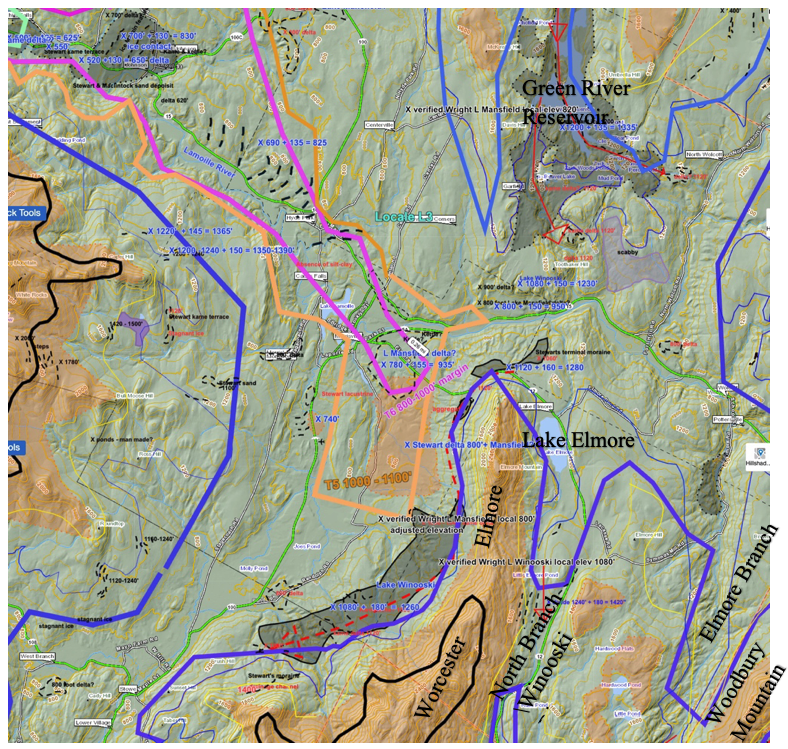
The T4 margin(heavy blue lines) in this Locale represents the same ice lobe extending up the Lamoille basin as identified in Locales L1 and L2. The south side of this lobe between Hardwick and Morrisville includes two small low areas – between Woodbury Mountain and Elmore Mountain(at the north end of the Worcester Range), one associated with Lake Elmore extending southward across the divide with the North Branch Winooski River and the other with Elmore Branch, all as marked on the above map. These two areas are mapped as glacial till by Stewart and MacClintock, and are largely unmarked by identifiable ice margin features on LiDAR imagery. Soils mapped as favorable for sewage suggest that these low areas at the north end of the Worcester Range were occupied by small Lamoille tributary ice lobes, extending southward to divides with the Winooski Basin. The absence of stagnant ice deposits at the T4 margin in these two lobes is not understood. LiDAR imagery suggests that meltwater at the frontal tips of these sub-lobes extended across the divides, with minor channel-like drainage features, but likewise is not marked by substantial deposits at the T4 ice margin in the Winooski Basin. Perhaps the Worcester Range served to deprive sediment in the ice on its lee side.
In contrast, a substantial deposit, topographically appearing as a high bench along the western flank of the Worcester Range is marked on VCGI as a gray shaded stagnant ice feature. A small portion of this deposit is mapped on the State Surficial Geology map as “beach gravel” and “pebbly sand.” The aggregate tab on VCGI(based on the Vermont Highway Department survey in the 1960s) shows substantial sand and gravel in this deposit. The SCS soil sewage favorability VCGI tab indicates that this deposit consists largely of granular soils. LiDAR imagery shows the bench-like top of this deposit is relatively flat, but with subtle undulations suggestive of kamic origin. This deposit is interpreted as a kame terrace and kame delta. The elevation of this feature is at the T4 margin and corresponds with Lake Winooski.
The presence of Lake Winooski kame delta deposits along the T4 margin on the western flank of the Worcester Range in Locale L3 and at Hardwick as described for Locale L2, suggests that the T4 lobe ice margin extended between the two Locales, with a crevasse fragmented, “Disaggregated” stagnant ice margin permeated by Lake Winooski waters.
On the north side of the T4 Lobe is a very substantial stagnant ice deposit in the Green River Reservoir area, including esker remnants, with elevations indicative of southward drainage of meltwaters in this deposit, as marked by a Drainage Line, from a divide area with another stagnant ice deposit to the north in the Eden area, in Locale L4. Two Drainage Lines, as marked by red arrows on the VCGI map are traceable southward through the stagnant ice deposit to deltaic deposits(?) which are slightly above Lake Winooski, likely representing a local proglacial lake, or possibly the remnant of the upper portion of a Lake Winooski delta.
Also present in Locale L3 are the frontal tips of the T5 1000 -1100 foot(305 – 335 m) and T6 800-1000 foot(244 – 305 m) Lamoille ice lobe margins, which are drawn based on step-down kame delta deposits immediately east of Morrisville, with a continuation of T6 ice margin recessional features to the west on the floor of the basin as marked on the above map. The discussion of this recession is continued in Locale L6.
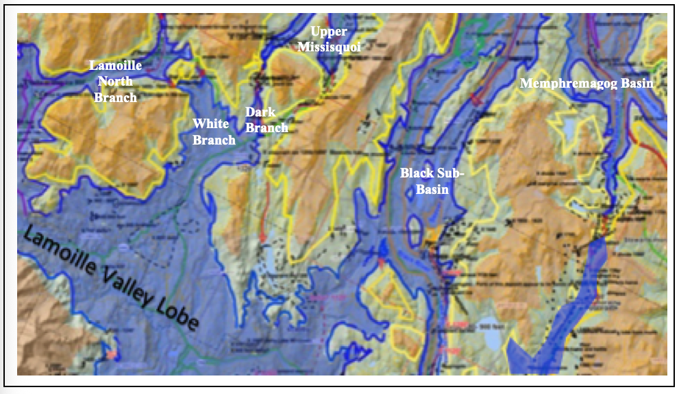
This Locale is presented to provide the documentation for the north side of the T4 Lamoille lobe, for a sub-lobe which extended northward into the Gihon Basin, the headwaters of which fork into an eastern sub-basin occupied by the Dark Branch drainage to a divide with the Upper Missisquoi Basin, and a western sub-basin occupied by the White Branch which extends to a divide with the North Branch Lamoille Basin, west of the Ritterbush Pond area.
The following map is from the VCGI base map for this Locale:
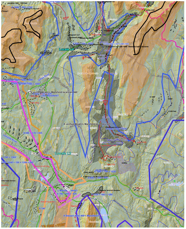
As can be seen on the above map, Ice Marginal Channels are numerous in this area. In the Upper Missisquoi Basin to the north, Channels demarcate an ice lobe as high as 2000 feet, and mark the progressive recession of an ice lobe downward to stagnant ice deposits at the T4 level. In the North Branch Lamoille Basin to the west, Ice Marginal Channels similarly demarcate a recession of the ice sheet, downward to stagnant ice deposits at this level. On the east side of the Gihon Basin, in the Dark Branch sub-basin, stagnant ice deposits are extensive at the T4 level. Together, these and other similar features define the T4 ice margin. As can be seen on the map, in the headwater areas of all these basins are Ice Marginal Channels, stagnant ice deposits, and Drainage Lines, all of which together document the commingling of the ice sheet across basin divides with separation in divide areas at T4 time.
The following map is taken from an earlier, modified version of the VCGI map, which more clearly illustrates the northern T4 Lamoille ice sub-lobes and related physiography in this region, with the blue shaded areas representing the ice sheet at T4 time:
Returning to the VCGI map for this Locale, Drainage Lines, marked by red arrows on the VCGI map, show remarkably intricate details about drainage in both north and south directions across drainage divides between the Upper Missisquoi Basin and the Dark Branch Basin, and as well downgradient within these basins. Two long Drainage Lines in the Dark Branch Basin, in places marked by eskers, extend southward from the Upper Missisquoi divide into and through stagnant ice deposits near Eden Mills, continuing through the South Pond area, across a local divide, into another T4 stagnant ice deposit near Green River Reservoir. These Drainage Lines grade into deltas at the 1120 foot(342 m) level, which appear to be slightly above the level of Lake Winooski, or at this level as upgradient deltaic remnants. The southern portion of the VCGI map overlaps with Locale L3 as discussed previously.
In contrast, at similar elevations in the neighboring White Branch Basin, likewise a sub-basin of the Gihon, this basin is strikingly relatively barren of stagnant ice deposits as compared to the Dark Branch, despite both being at the approximately the same elevations. The explanation for the difference is believed to be related to the physiography as a matter of physiographic and “Style” differences. Whereas the T4 ice margin in the Dark Branch rested on a bench resulting in relatively thin ice which favored stagnation, in contrast the White Branch headwaters lacked such a bench, with a lower basin floor extending into the Ritterbush Pond area to the base of a steep walled headland east of the divide with the North Branch Lamoille Basin which is at an adjusted elevation of 1360 feet. As a consequence of this physiography the T4 ice margin extended as an active ice lobe on the floor of the White Branch sub-basin, with ice flow supply from the main Lamoille lobe into the Ritterbush Pond area.
On the floor of the basin in the Ritterbush Pond area, immediately east of present day Ritterbush Pond, Wagner previously reported moraine-like ridge deposits. These are too large and well developed to be lake ice-shove rampart ridges for the relatively small size of Ritterbush Pond, and are in a location incompatible with protalus ramparts. Accordingly, these features were identified in a previous report, along with features in the Miller Brook and Lake Mansfield area, as being local valley glacier deposits, including a moraine. Wright et al studied the Miller Brook deposits in more detail, concluding that Wagner’s moraine is an esker deposit. With the benefit of this present study, I now believe that the Ritterbush pond moraine-like features, as with the Miller Brook features, represent deposits associated with Disconnected ice masses, associated with the Lake Winooski strandline.
Accordingly, these features were identified in a previous report, along with features in the Miller Brook and Lake Mansfield area, as being local valley glacier deposits, including a moraine. Wright et al studied the Miller Brook deposits in more detail, concluding that Wagner’s moraine is an esker deposit. With the benefit of this present study, I now believe that the Ritterbush pond moraine-like features, as with the Miller Brook features, represent deposits associated with Disconnected ice masses, associated with the Lake Winooski strandline.
d. Locale L5
Locale 5 documents the deglaciation record in the North Branch of the Lamoille Basin, extending northward from its juncture with the Lamoille Basin near the mouth of the Basin(discussed subsequently below at Locale L6), into the mountainous area near Belvidere Pond, just west of the Ritterbush Pond area as previously discussed for Locale L4, and continuing northward to a divide with Trout Branch, a sub-basin of the Missisquoi in the Champlain Basin(which is discussed subsequently below as part of Locale CG3 for the northern Champlain Basin lobe).
The VCGI map below shows the L5 Locale:
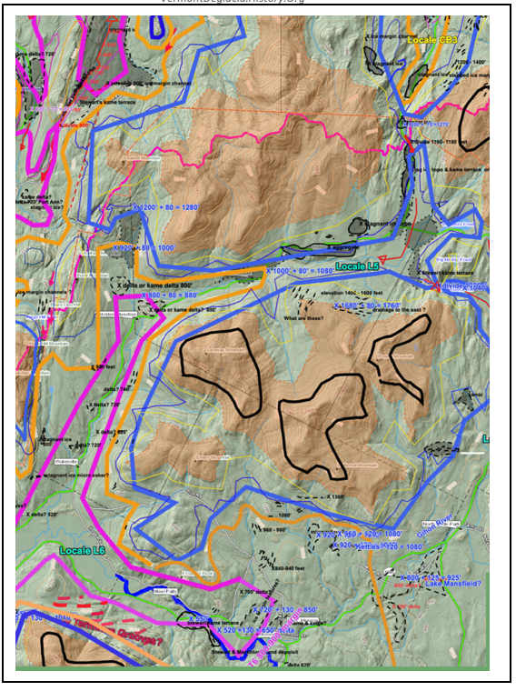
The above map has since been altered with regard to the nearby Shattuck Mountain Pothole tract. Unfortunately, at the time of this writing VCGI developed a quirky functioning which prevented displaying drainage basin boundaries. Hence the above map was not updated. However, the changes related to the pothole tract are minor relative to the issues of interest for this Locale. Hence, the older VCGI map is retained.
Ice Marginal Channels in this Locale mark ice margins which clearly document the early, incipient development of ice lobes in the Nunatak Phase, along the south side of an ice lobe in the North Branch Valley from upper, adjusted elevations of about 1800 feet, downward to about 1200 feet. To put this area into Statewide perspective, in southern Vermont the T3 margin in southern Vermont in the Vermont Valley was at an elevation of 2000 feet. Thus, the ice sheet was still in the Nunatak Phase in this area in northern Vermont when deglaciation was more advanced in southern Vermont, as would be expected.
The deglaciation story in the Northern Lamoille Basin is one of progressive, steady recession of the ice margin from T4 1200-1400 foot(366 – 427 m) time which marks the beginning of the Lobate Phase. At T4 time the North Branch Lamoille sub-lobe lobe extended to divide areas with the neighboring drainage basins to the east and northeast near Ritterbush Pond and Belvidere Pond, to the north at a divide with Trout Branch in the Missisquoi Basin, and to the northwest at a divide area east of Bakersfield. In general, ice recession in the North Branch Locale L5 area can be likened to multiple, closely spaced rings on a “Bath Tub,” punctuated by stillstands at discrete T levels, as shown on the above VCGI map.
e. Locale L6
This Locale is located at the mouth of the Lamoille Basin where it penetrates the Green Mountains, per the following VCGI map:
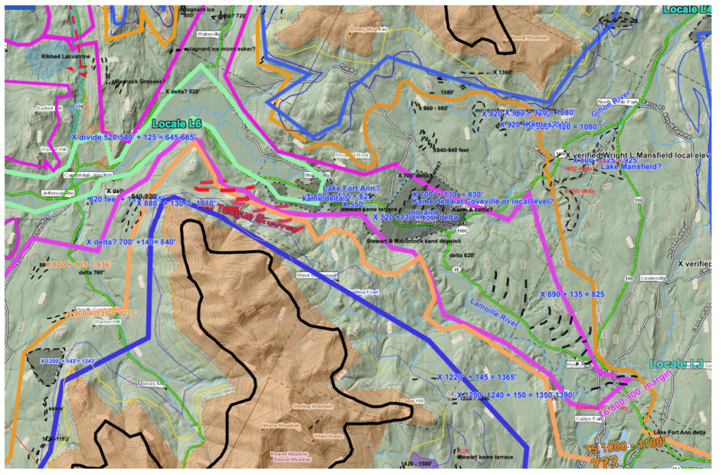
Many aspects of this Locale are discussed in the above text in regard to Ice Tongue Grooves, and this discussion is not repeated here. Features mapped on VCGI demarcate the T4 1200-1400 foot(366- 427 m)(blue), T5 1100-1000 foot(335 – 305 m)(orange), T6 800-900 foot(244 – 274 m)(maroon), and T7 600-700 foot(183 – 213 m)(sage) ice margins, as marked on the above map. The T4 margin in this Locale is mostly marked by Ice Marginal Channels. At T4 time, as indicated elsewhere in this report, the ice margin extended well into the Lamoille and Winooski Basins, with associated Lake Winooski features close to the T4 ice margin. Also as previously noted, the T5 and T6 ice margins are closely associated with Wright’s Lake Mansfield. In Locale L6 the T5 margin is marked on the north side of the Lamoille Basin, east of the North Branch Lamoille juncture near Jeffersonville, by Ice Marginal Channels and “micro-eskers, ” which are sinuous ridge like, features sloping down, southward from the T5 margin. As drawn on VCGI, in the Lower Gihon Basin, is a deltaic deposit(?) which is correlated with Wright’s Lake Mansfield. The T5 and T6 margins are intentionally drawn along the lower margin of this delta to suggest the presence of Lake Mansfield along the north side of the T5 and T6 margin.
The T5 and T6 margins are drawn as a lobate form extending up the Lamoille Basin floor to a substantial kame delta deposit at the Lake Mansfield level, as shown. The south side of the lobe at the T5 and T6 levels is not marked. However, as just noted, at the mouth of the Lamoille Basin, East of Cambridge Junction, are features marked on VCGI as “ Ice Tongue Grooves,” which are similar to features at the mouths of the Winooski Basin and lower Missisquoi Basins. As described in detail in the section of this report presenting Ice Tongue Grooves, the Lamoille Basin Ice Tongue Grooves are interpreted as indicating a destabilized ice margin, bordered by a narrow standing water corridor along the eastern T7 margin, which corresponds with Fort Ann Lake Vermont.