The VCGI evidence generally shows that both active and stagnant ice margins, as referred to above, are more fully developed at locations which can be inferred as marking the frontal positions of both ice and meltwater flow paths by which more substantial ice margin deposits were constructed. It is clear that these ice margin features developed preferentially at locations where conditions were more favorable in terms of physiography relative to ice and meltwater flow. For example, the following schematic gives an aerial view of a hypothetical ice sheet in multiple basins, including the main basin and tributaries, with the ice sheet flow from the northwest, and becoming adjusted to some extent by the basin physiography. This schematic was drawn with the main Champlain Basin and a major tributary basin such as the Lamoille Basin in mind.
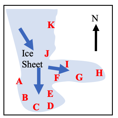
In this schematic, based on experience with VCGI mapping, certain positions are more favorable for ice margin development, specifically positions C, D, F, H, and J. In contrast positions A, B, E, and I are less favorable. Of course, this is a generalized observation, with favorability depending on a variety of factors. This schematic also applies to both ice and meltwater flow directions and patterns.
During the course of mapping in time one develops an intuitive sense of the movement of both ice and meltwater whereby more substantial deposits are expectable. For example the above schematic is intentionally drawn with a physiographic projection at position J. This was drawn with the Shattuck Mountain Potholes in mind, it being suspected that a terrain projection on the downgradient, eastern ice margin served to collect and impound meltwater in the embayed margin at that location. This same thinking applies to the development of the narrow open water corridor along the eastern margin of the ice sheet, Bedrock Grooves at position K, and as well Ice Tongue Grooves at position F. In essence, this schematic is intended to illustrate how the mapping and interpretation of ice margin features on VCGI is based on geological thinking which makes sense, is reasonable, and thus adds support to the interpretations and findings. Of course, this thinking also is time transgressive, as marked by step-down ice margin features, most of which are in a reverse gradient setting in Vermont.
In addition, to ice and meltwater flow directions relative to physiography, ice thickness also was a factor affecting the development of ice margin features. For example, stagnant ice deposits margins developed preferentially at locations where the physiography resulted in thinner ice, as compared to locations nearby where at the same time the ice was thicker, favoring active ice.