These are small bench-like terraces on hillside slopes, usually mantled by till, oriented parallel to the topographic contour, and most commonly occurring in multiple series, giving a stair-step pattern. In some cases, the terraces are pronounced and obvious, but most commonly are very subtle, marked by a very feint tonal differences on LiDAR imagery. In some places the LiDAR “slope angle” feature accentuates the appearance of steps and makes them more discernible.
An example of Ice Margin Steps is on the east side of Belvidere Mountain, near an old asbestos mine identified as “Tillotsin Mill.” The screenshots below are from the VCGI base map with USGS topographic base map on the left and LiDAR imagery on the right. Of course, to be certain that the “micro-steps” are not reflecting bedrock structural grain would require field checking but seems unlikely.
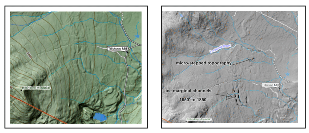
As can be seen the “Steps” are subparallel to the topographic contour, discontinuous, with step risers too small in height to be marked by topographic contours. Also shown are nearby Ice Marginal Channels, one of which diverts surface water drainage. It seems likely that Ice Marginal Channels and Steps are on a spectrum, perhaps with a related nature. Steps are believed to have formed at and near the ice sheet margin. They are predominantly in till, but whether or not granular soil material indicative of flowing water action in their formation is present is unknown. An alternative hypothesis is that the steps were formed by the weight of ice blocks near the ice margin. Clearly, detailed field work is needed to further assess their origin and significance.
Wright (2019) 1 Wright, S.F., 2019, Lateral Recessional Moraines in the Green Mountains of Northern Vermont; NE Geol Soc America Sectional Meeting Paper 13-7. identified these same features, which he interpreted as lateral recessional moraines. Whereas strictly speaking lateral moraines are regarded as having formed along the sides of ice margins, more or less parallel with ice flow, Wright interpreted these features as push moraines associated with ice recession. In the interpretation given here, these “Steps” are regarded as marking the ice margin, in close association with Ice Marginal Channels which together delineate the progressively receding margin of the ice sheet in the Nunatak Phase. For example, the following screen shot shows a broader area, which includes the area of steps near Tillotsin Mill, which is near the head of the Upper Missisquoi Basin and as well includes portions of the Lamoille Basin to the south and as well to the west.
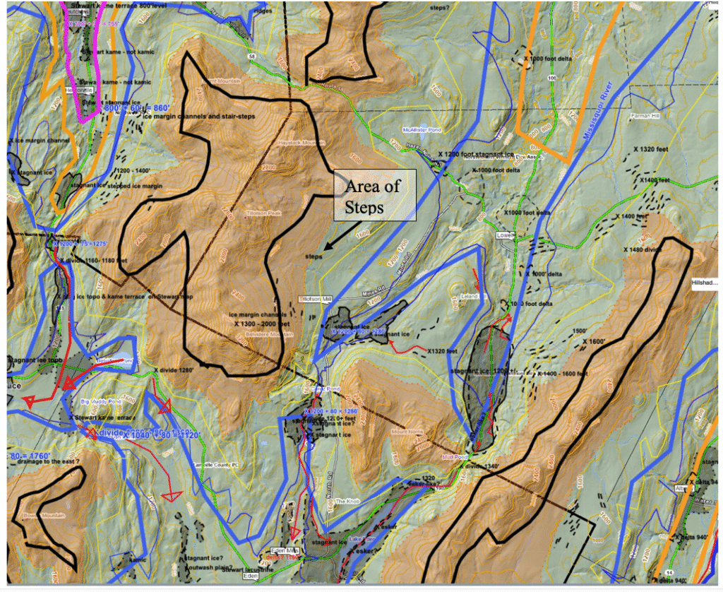
In addition to the steps in the area as reported by Wright, Ice Marginal Channels are numerous in many other locations in the upper Missisquoi Basin and neighboring areas. Again, these Channels are designated by short black colored lines. Also, substantial stagnant ice deposits are marked by gray colored areas. The T4, T5, and T6 ice margins are delineated by the heavy blue, orange, and maroon lines, respectively. As can be seen, the Ice Margin Channels, and as well the Steps, which on this map are relatively small and difficult to identify, together delineate ice margins suggestive of ice lobes which occupied these basins here interpreted as in the Nunatak Phase, with recession of the ice margin downward to basin floors where the T4 margin marks the beginning of the Lobate Phase. The same can be seen in neighboring basins to west in the North Lamoille Basin, to the south in the Gihon and White Branch Basins in the Lamoille Basin, and to the east in the multiple basins within the Memphremagog Basin.
Whereas we both recognize the same Step features, Wright and I differ in that at this point: 1) I am unprepared to opine about the origin of the Steps except that they are ice margin features formed in till, and 2) my interpretation identifies and interprets the Steps in a broader context of different types of features in a recessional history using the “Bath Tub Model.” In this broader context, I interpret the Steps as part of evidence which taken together documents the deglacial recession of the ice mass in the Upper Misissquoi Basin, from the Nunatak Phase to the Lobate Phase. Thus, whereas Wright examines these features in and of themselves as local features, in my view they can more effectively be used with other evidence as part of the deglacial history of a broader area. However, to do so entails examining all available lines of evidence in the context of regional deglacial history.
Another example of these features is near Hectorville, on the west side of Belvidere Mountain, in till near the slope base at elevations between about 840 – 1000 feet(256- 305 m):
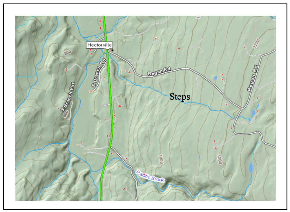
Again, Ice Marginal Channels are identified in this area, at a higher elevation on the same hillside, as can be seen on the above map.
Many years ago, I identified step-like features on the western flank of Mount Mansfield, as seen from afar. These were only visible under certain late-day lighting conditions and only from certain vantage points, resembling multiple lake strandlines (similar to and suggestive of strandlines as marked by the well-known strandlines for Lake Bonneville in Utah, which likewise are quite striking when seen from afar). These features likely are stepped terrain in glacial till, unrelated to proglacial lakes. The west side of Mount Mansfield, like many other western flanks of the Green Mountains, is veneered by a thick deposit of glacial till, resembling a rampart on the stoss side of the mountain (as compared to shallow bedrock on the eastern lee side). I have long interpreted this till rampart as the ice sheet’s way of building a platform to make it easier for ice to cross the mountain. As the ice sheet receded it is inferred that steps in this till rampart formed. The mechanism of formation is unclear but likely was not related to meltwater erosion, perhaps more likely to molding of the till by the weight of the ice sheet or perhaps some other mechanism such as suggested by Wright and others.